
-
 7096 Hits
-
 87.76% Score
-
 25 Votes
|
|
Route |
|---|---|
|
|
46.46860°N / 11.62760°E |
|
|
Trad Climbing |
|
|
Summer |
|
|
Half a day |
|
|
Alpine D+, UIAA V |
|
|
8 |
|
|
Overview
Geographical classification: Eastern Alps > Dolomites > Catinaccio Group > Punta Emma > Via Fedele
Punta Emma m 2617 - Via Fedele
Punta Emma m 2617 is a stunning tower overlooking Vajolet and Preuss shelters, well known in reason of its fine and frequently attended classic climbing routes of the Catinaccio Group. Its location is tightly close to Catinaccio mighty East wall, reason why Punta Emma - despite its attractiveness - is somewhat a bit shadowed. The main routes are Piaz Crack, Steger and Fedele. This latter provides a rock of good quality and an interesting climbing line, particularly if it's followed the direct variant, offering the opportunity of experience the main various climbing styles of the Dolomites. The route takes place on the South-East wall, facing the Gardeccia basin.
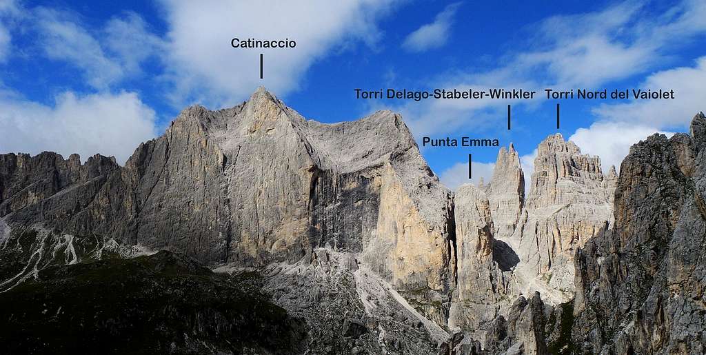
Catinaccio, Punta Emma and Vaiolet Towers from Campanile Gardeccia
Getting There
The starting point to climb Punta Emma is the Gardeccia, approachable from the village of Pera di Fassa.
Road access to Pera di Fassa
- from Trento follow the Brennero Motorway towards North, exit Egna-Ora and take the road S51 towards Fassa Valley, getting to Cavalese, Predazzo, Moena and Pera di Fassa (48 km. from Egna-Ora).
- from Bolzano follow the Brennero Motorway towards North, exit Prato all’Isarco and take the road to Carezza Lake, Passo Costalunga, Fassa Valley.

|

|
Approach to Gardeccia
The road from Pera di Fassa to Gardeccia is open to private vehicles as far as the little hamlet of Soial. The minibus service is no longer available. There is the chair-lift starting from Pera di Fassa, rising to the upper station near Refuge Ciampedie, from which Gardeccia is attainable in 40 minutes by walk. Alternatively cable car from Vigo di Fassa to Ciampedie.
Route Description
Punta Emma Via Fedele report – UIAA scale

Summit altitude: m. 2617
Difficulty: D+, max UIAA V
Equipment: pegs
Climbing length: 250 m
Exposure: South-East
First ascent: F. Bernard, G. Masè Dari 1929, july 16th
Starting point: Gardeccia basin
A stunning classic climb of the Catinaccio group. The first original lengths have been abandoned in favour of a more direct start that is the one described here. Not a very continuous route, but with some steps not to be underestimate. The route also offers all the different styles of Dolomites' climbing, as dihedrals, slabs, cracks and chimneys.
Approach
The path to approach Punta Emma starts from the small hamlet of Gardeccia, which cannot be reached by car because of the driving ban throughout all the year. See the "Getting there section". From Gardeccia follow the gravel road (trail no. 546) that goes to the Vajolet and Preuss shelters, taking wonderful views over the imposing Catinaccio East wall and over the slender Punta Emma located on the right of Catinaccio main summit. Arrived at the shelters follow briefly the trail. 542 that goes up to the Re Alberto shelter. On the left you can see Punta Emma and the unmistakable oblique ramp (from right to left) where the route Steger starts. Leave the main path and head to left; continue crossing to the left on a ledge, pass the ramp, and carry on skirting the wall. The starting point is on the right of the first notch separating Punta Emma from Catinaccio East wall, below a dihedral.
Route report
L1 - Climb easily to reach a ramp slanting right. Follow it up to a terrace. Belay on the terrace under a dihedral. III, IV, 35 m.
L2 – Climb the dihedral to the belay IV +, IV, 25 m.
L3 - Continue up the dihedral, then head to right and climb a short slab, beyond which belay on the terrace. IV, IV+, 30 m.
L4 – Slanting right, then straight heading to a smooth slab with black slit to the right. You stop (2 nails) shortly before reaching it. 45 m., III, II, IV.

|

|
L5 – Climb the beautiful black slab which is located on the left side of a thin crack. At its end head to left, reaching a ledge. Belay on the ledge. IV+, V, 40 m.
L6 – Slanting left head to another black slab. Climb it, then with the help of a blade reach a small yellow overhang. Deal it directly and belay on the balcony above. IV, V , 30 m.
L7 – Climb a shallow black corner over the stance, then up directly heading towards a chimney. Climb the chimney for a few meters and belay. IV+, IV, 35 m.
L8 – Up the chimney again. Just before its end get out to the right and belay on a big spike to be equipped. IV +, IV, 40 m. Last 150 meters: from the belay climb up for about 150 meters on easy rocks, then up a scree to the summit of the tower. I
 seen from the summit of Punta Emma")
Descent: from the peak head towards the refuge Re Alberto (well visible), following an obvious track (cairns) sloping to the north-west wall. With a short section very exposed traverse heading to the rocky saddle between Punta Emma and Catinaccio. At a small terrace with a fixed anchor marked by a cairn abseil down and reach the gully below. Scramble down to get the Gartl basin and the path joining the Vajolet and Preuss shelters to Re Alberto shelter. Turn to right to reach the Vajolet and Preuss shelter, then Gardeccia.

|

|
Essential Gear
The route is equipped, bring only normal climbing equipment and some friends to integrate
Red Tape
Private cars are not allowed beyond the hamlet of Soial. Apart from this limitation in the movement of private vehicles, there are no particular restrictions in climbing and hiking. Punta Emma and the whole Catinaccio-Rosengarten Group are located inside the Natural Park Sciliar-Catinaccio and Latemar. This area, shared between the provinces of Bolzano and Trento, is one of the nine mountain systems of the Dolomites acknowledged as UNESCO World Heritage Site. More info here on SP: Dolomites living mountains.
This area is one of the most important systems worldwide for the study of the stratigraphy of the Triassic, in reason of the plenty of fossils on Alpe di Siusi, the relationship between carbonate and volcanic sediments, and the fact that the outcrops are easily accessible. The Catinaccio Group forms a series of peaks and sharp needles showing the movement of an island which sank into the sea 240 million years ago.
Huts
- Rifugio Gardeccia 1949 m. Situation: Gardeccia basin Open: from June to the end of September - from Christmas to Easter open during the day (no overnight in this period) Size: 43 persons Getting There: by walk from Soial, alternatively by minibus from the chair-lift station in Pera di Fassa Phone: 0039 0462 763152 Mobile: 0039 335 7432677 - 0039 335 7432676

- Rifugio Stella Alpina Situation: Gardeccia basin Size: 50 persons Getting There: by walk from Soial, alternatively by minibus from the chair-lift station in Pera di Fassa Hut's phone : 0039 0462 760349

- Rifugio Vajolet 2243 m, SAT Trento Situation: near Catinaccio and Torri del Vajolet Size: 130 persons Getting There: by walk from Gardeccia Mobile:0039 335 7073258 Huts'Phone: 0039 0462 763292 E-mail: info@rifugiovajolet.com
- Rifugio Preuss 2243 m Situation: near Catinaccio and Torri del Vajolet Size: 10 persons Getting There: by walk from Gardeccia Mobile:0039 368 7884968 E-mail: info@rifugiopaulpreuss.com
When to climb
The best period goes from June to the end of September
Meteo
METEO TRENTINO
DOLOMITI METEO - TRENTINO
Guidebooks and maps
-Guidebooks
- "Arrampicare - Dolomiti Nord-Occidentali" by Matteo Bertolotti, Luca Galbiati, Francesco Vascellari, Vividolomiti
- "Arrampicare sul Catinaccio e dintorni" by Mauro Bernardi, Ed. Athesia, 2013
- “La nuova guida del Catinaccio” by Antonio Bernard, Ed. Mediterranee, 2008 – A wide selection of the Catinaccio group climbing routes
- "Gruppo del Catinaccio" by Andrea Gabrieli - Luca Visentini Editore
- “Catinaccio” by Dante Colli and Gino Battisti, Tamari Editori in Bologna, 1984


- Maps
- "Val di Fassa e Dolomiti Fassane" - Tabacco sheet 06 - 1:25.000
- "Rosengarten Catinaccio/Latemar" - Compass 1:25.000
 |
 |