
-
 58645 Hits
-
 89.77% Score
-
 30 Votes
|
|
Canyon |
|---|---|
|
|
33.76910°N / 111.12°W |
|
|
Canyoneering |
|
|
Spring, Summer |
|
|
Overview
Salome Canyon is a technical canyoneering adventure located in the Sierra Ancha Mountains north of Roosevelt Lake in Arizona. It is found within the Salome Wilderness Area which encompasses 18,530 acres in the Tonto National Forest. Created in 1984, the Wilderness ranges in elevation from 2,600 feet to 6,500 feet. The Wilderness is named after Salome Canyon which traverses nearly the entire length. This area was home to the prehistoric Salado Indians, and ruins dot the area. If you happen upon a ruin, please do not disturb artifacts as they are protected by Federal Law. There are few trails that enter this wilderness and access can sometimes be difficult. The main trails are the Cactus Butte Trail, The Jug Trail, Boyer Trail, and Hell’s Hole Trail.
The canyon itself is typically broken into two sections, Upper Salome Canyon which requires a long approach and semi-technical canyoneering, and the lower section which is easily accessed and boasts some of the best technical canyoneering in Southern Arizona.
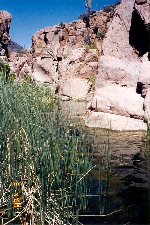
This is the first deep pool that requires a swim.
The lower canyon is carved just beneath Dutchwoman Butte, and is comprised of basalt and granite in shades of pink and white. Nicknamed ‘The Jug’, this lower section requires at least one rappel and multiple swims. Using the American Canyoneering Academy rating system, this canyon receives a 3C II which indicates that it requires swimming and rappelling, there is strong water current and a waterfall, and it can be done in a half day, car to car. The entire length of the trip is around 5 miles (1 mile of it in the canyon) and can be completed in about 4-5 hours.
Please note several potential dangers of this canyon:
1. It can receive heavy runoff during the spring and monsoon season (July-August). I have been there when the water is quite high with a heavy current. Please use caution.
2. Due to the higher elevation and more northern location, the water can be quite cold much of the year. You may consider wearing a wet or dry suit if you are not doing the canyon in May, June, or September.
3. The Naegleria fowleri amoeba killed a boy swimming in Lake Havasu in western Arizona, and has been found in Tucson’s water supply. The amoeba eats the brain and enters by snorting infected water through the nose. Drinking the water has no effect. It is found primarily in warm water in southern states, and is stirred up by wading in shallow water. Although there is no evidence that it is found in the Jug, caution may be warranted. You can read the MSNBC story here.
4. There is plenty of water in this canyon. I have had electronic equipment ruined. We also had to drive two men back to Phoenix when they lost their keys in one of the pools. Be sure to either bring equipment you don't mind getting wet, or packing your gear in dry bags or sacks.
5. Watch for rattlesnakes. I personally have never encountered one in my four trips to the area. However, others have...and the area around Roosevelt is known for Diamondback Rattlesnakes. I have also encountered the Arizona Black Rattlesnake not too far from this area...so care is required. Remember that rattlesnakes will not attack unless cornered. So, if you see one, just back off slowly and leave it alone. A nurse I talked to at UMC in Tucson told me that the only folks who come in with snakebite are either drunk or were trying to mess with the snake.
Canyon Description
Hike down the old road to the canyon, head north through a barbed-wire fence and gate (make sure you close it – there are cattle grazing in the area) and look for weaknesses in the cliffs that allow you access to the canyon bottom. You will probably have to travel several hundred yards upstream until this is possible. The Jug itself is hard to miss with its pink and white granite cliffs.
Once in the canyon, head downstream. At first the canyon is very open with granite boulders lining the sides. The pools are shallow and full of plants you will have to navigate. Soon, you will encounter your first swim amid cattails. Once through this swim, the wading again takes over and you will be wading shallow pools interspersed with rock hopping.
After a bit, the canyon walls start to narrow, the terrain becomes a bit steeper, and the pools become deeper. At this point you will encounter a natural water slide on the left side of the canyon. If there is enough running water, slide down this and be on your way. Otherwise, go to your right and find a weakness that allows you down the wall. From here, the walls steepen and narrow to about 20 feet, and the swimming starts to take over. You will be swimming 50-100 foot pools interspersed with rock hopping and bits of class 3 downclimbing.
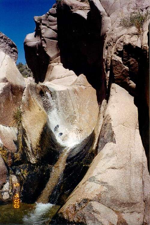 The water slide that marks where the real adventure begins.
Eventually you will get to a 50 foot waterfall (it could be dry). This is the heart of “The Jug” and the best part of the whole canyon! There are two options here, to jump or rappel into the pool at the base of the waterfall. Either method requires you to traverse the 20 foot sloping ramp on the right side of the falls to a chain anchor. There are also several good bolts near the waterfall that you could rap off as well. One is to the right of the waterfall down by your feet. One is located above that one on the wall. The ramp is slick when your shoes or sandals are wet! Use caution. Sometimes people tie a sling from the bolts near the waterfall to the ones at the end of the ramp for use as a handline. Some people also opt to attach a short webbing hand line to the bolts at the end of the ramp, downclimb a bit, and jump into the deep pool at the bottom to avoid the rappel. I recommend bringing your rope and harness and rappelling into the pool because you never know what the last flash flood has brought and dumped into that pool that you can’t see.
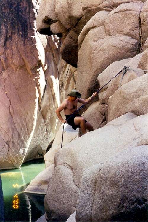 Rappelling the waterfall. The waterfall is unseen in the picture to the left.
The pool is deep enough that you need to swim while unhooking your belay device. Be careful not to lose it! There is an old ATC stuck in the rocks at the bottom of the waterfall as evidence of this! I opted to just pull my rope through and swim out with my belay device still attached. There are a couple of ledges underneath the waterfall that you may be able to get onto, but it all depends on how high the water level is.
From there, enjoy the best that Salome has to offer. Swim two large 200 foot pools until the canyon opens up and the walls end. From there, find a trail to your right up the hill that connects with the road/trail you came in on and hike back to your car.
Getting There
From Phoenix:
Take 87 (Beeline Highway) to 188. Take 188 south. Eight miles south of Punkin Center around milepost 255, take a left onto 60 aka A Cross Road. Take this dirt road (should be fine for passenger cars with a little care) 10 miles to the unmarked trailhead. The unmarked pullout will be on the right at the top of the hill just west of Dutchwoman Butte. You will see an old road zigzagging its way down into the canyon bottom.
From Globe:
Head east on 60 until you reach 88. Go north and turn right onto 288. Head north for approximately 12 miles until the road turns to dirt. From here turn left onto 60. There is a sign pointing the way to Salome Creek. Go west approximately 12 miles. You will pass a house and go over a concrete spillway of Salome Creek, then head steeply uphill for several miles. On the left will be a weird brown ‘building’ which is a water catchment. The unmarked pullout will be on the right at the top of the hill just west of Dutchwoman Butte. You will see an old road zigzagging its way down into the canyon bottom.
The Adventure Hikes and Canyoneering in the Southwest website by Chris Brennan has Latitude and Longitude Coordinates for the parking area and trailhead, the wilderness gate, the downclimb into the canyon, the end of the canyon, and the junction of the trail you hiked in on and the exit trail from the canyon. I have not checked them for accuracy, but they can help immensely, especially for finding the trailhead.
Essential Gear
Dry bag or dry sack - This canyon typically has a lot of pools, even during dry years, and it is recommended to bring stuff you don’t mind getting wet…or bring a good dry bag or sack. The dry bag or sack has the added advantage of holding enough air to float your daypack during the swims.
Rope (at least 100 feet)
Harness
Belay/rappel device
Extra webbing for use as potential handlines
Pack
Dry Suit (In colder weather)
Red Tape
Group size is limited to no more than 15 people and 15 pack or herd animals in the wilderness. Normal rules apply towards fish and wildlife.Camping
Dispersed camping for free is allowed in Tonto National Forest and in the wilderness area. However, there are no facilities such as toilets or water. Plan to bring your own water or filter water from Salome Creek. There are no problems with fires unless local fire restrictions are in effect. You may need to bring your own firewood since the local flora is typical Sonoran desert scrub and burnable material may be hard to find. Consider using a backpacking stove.Maps & Books
USGS 7.5 minute map Armer Mountain (AZ)Check out the pics and description of The Jug in Canyoneering Arizona available on Amazon, at REI in Phoenix, and local shops such as Summit Hut in Tucson.
Adventure Hikes and Canyoneering in the Southwest
American Canyoneering Academy
External Links
Todd’s Desert Hiking GuideAdventure Hikes and Canyoneering in the Southwest
American Canyoneering Academy