
-
 4855 Hits
-
 78.27% Score
-
 9 Votes
|
|
Mountain/Rock |
|---|---|
|
|
42.10219°N / 13.55264°E |
|
|
Download GPX » View Route on Map |
|
|
Hiking, Scrambling |
|
|
Spring, Summer, Fall, Winter |
|
|
6302 ft / 1921 m |
|
|
Overview
 Serra di Celano seen from the north Serra di Celano seen from the north |
Serra di Celano is part of the huge massif of Monte Sirente and as such the southernmost outpost of the range. It towers 100m above the town of Celano, which itself is located in the north of the circular plain of Piana del Fucine in the Abruzzo mountain range of northern Italy. Even though it is less than 2000m high, Serra di Celano towers more than 1000m above the town at its base. On three sides there are sheer drops while on the fourth Serra di Celano is connected with the Ovindoli plateau, from where it can be accessed most easily.
 |  |  |
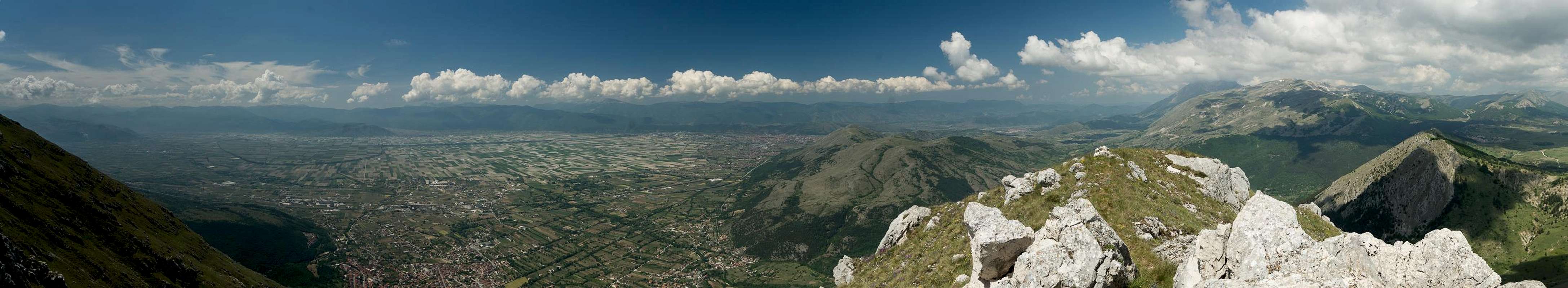
The mountain is composed of limestone rock, which forms a narrow, east-to west running ridge. While the main summit is more or less located in the middle of this ridge, an interesting steep and exposed traverse leads to the lower east summit. Here the ridge suddenly ends and you find yourself on a pulpit with sheer drops on three sides. Here you will get the best views towards Celano and its medieval castle and Piana di Fucine beyond.
 |  |  |
While the normal route from Ovindoli is little more than a stroll up to the slightly exposed ridge the second route, which heads through the imposing south face from Celano is a different matter. It gains 1000m of elevation on steep and sometimes exposed paths, which finally head out directly onto the main summit from the south.
 |  |  |
Serra di Celano is separated from the remainder of the Sirente Massif by a profound gorge, Gole di Celano, a narrow but deep cut into the karst plateaus of the mountain. It is a worthy destination in its own right, with the path starting in Celano istself, not far away from the trailhead for the south face route. In principle you can do a loop from Celano through the south face to the summit, descend towards Ovindoli and head back to Celano through the gorge. However, it will be a 10h hike with long distances and lots of elevation gain.
 |  |  |
From above, you can have excellent views into Gole di Celano from Serra dei Curti, Serra di Celano's direct neighbour to the east. Here the ridge is composed of several summits, easy to reach from the west but with sheer drops into the gorge in the east. Some of the summits require a bit of bushwhacking to reach and the lowest ones are covered in drarf beeches. Still this traverse is also rewarding even though it requires a bit of freestyling to return to the trailhead at Ovindoli.
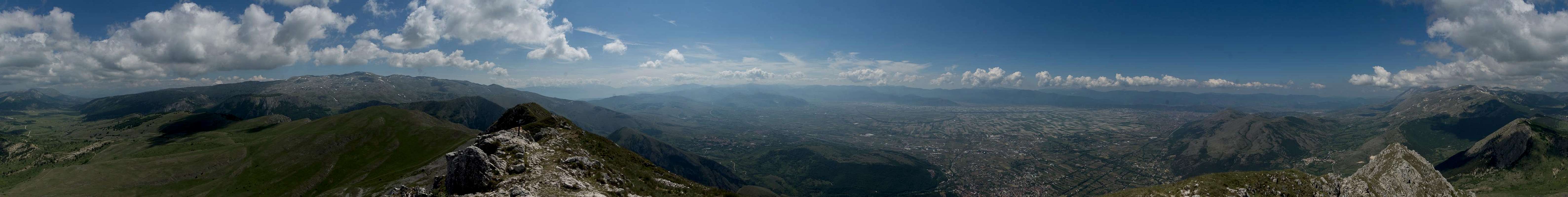
360° Summit Panorama
  |
Getting There
 Celano and Piana di Fucine
Serra di Celano is located directly north of the town of Celano, which itself is located to the north of the Fucine Plain. It can be reached from Rome or Pescara (the closest airports) via motorways A24 and A25. There are two trailheads, one in the town itself, one near Ovindoli, a village on the plateau north of Serra di Celano.
- From Rome:
- Take motorway E80 / A24 from Rome to Torano.
- Switch to motorway A25, direction Pescara.
- At the exit Celano switch to SS5 west for a few hundreed metres, than turn onto SS696 north north. The road leads through Celano to Ovindoli and thus serves both trailheads.
- Take motorway E80 / A24 from Rome to Torano.
- From Pescara
- Take motorway E80 / A25 westward in direction Rome.
- At the exit Celano switch to SS5 west for a few hundreed metres, than turn onto SS696 north north. The road leads through Celano to Ovindoli and thus serves both trailheads.
- Take motorway E80 / A25 westward in direction Rome.
Routes
 Serra di Celano: climbing the north gully
 There are two popular routes to Serra di Celano.
- The northern route starts near Ovindoli (in the south of the village) and follows a set of several dirt roads which lead to the mountain. The easist option stays close to the ridgeline and heads for a saddle right to the east of the summit ridge. From here scramble up several vertical metres until you reach the path on the narrow ridge, which heads for the main summit. As an encore you can descend the exposed west ridge to the western summit, which hovers directly above Celano. A very animated ridge traverse!
- Right in the centre of the city, close to the medevial castle a road turns off east, which heads into the south face of the mountain. After some 500m another path turns off north heading up the incredibly steep south face of Serra di Celano. It scales 1000m and meets the main summit directly from the south.
Red Tape
 |  |  |
In 1989, the Velino-Sirente Range was declared Parco Naturale Regionale Velino Sirente. Its Area is 50.288 ha and it is known to host Italian wolves and brown bears.
Basically the usual restrictions apply: there are neither fees or permits required but you need to stay on the marked trails. camping is forbidden altogether.
Weather Conditions
 Serra di Celano main summit
 Accommodation
 |
You can find a number of hotels in Celano on booking.com or tripadvisor.com. Additionally there is a list of hotels, appartments, holiday homes on the site of the Velino-Sirente Natural park:
Accommodation Velino-Sirente
Maps & Books
Maps
- Digital Maps
- Regular Maps
- Parco Naturale Regionale Sirente Velino
S.EL.CA
1:25.000
- Velino Sirente
Il Lupo
1:25.000
ISBN: 978-8888450407
- Parco Naturale Regionale Sirente Velino
Books
- Sirente Velino. Passeggiate ed escursioni sulle vette più belle del Sirente Velino
Emanuele Lucchetti, Bruno di Baggio, Fabio Beolchi
Technopress
ISBN: 978-8897997184
- Escursioni. Appennino centrale. Laga, Gran Sasso, Velino e Sirente
Alessandro Petretti, Francesco Petretti, Gaetano Petretti
Cierre Edizioni
ISBN: 978-8886654791
- Trekking in Abruzzo. 60 sentieri
Emanuele Lucchetti, Bruno di Baggio, Fabio Beolchi
Technopress
ISBN: 978-8897997078
- A piedi sul Sirente-Velino
Stefano Ardito
Iter Edizioni
ISBN: 978-8881770182
- Abruzzen
Heinrich Bauregger
Rother Verlag
ISBN 978-3-7633-0413-2