
-
 5432 Hits
-
 74.92% Score
-
 5 Votes
|
|
Route |
|---|---|
|
|
45.03671°N / 109.55117°W |
|
|
Hiking, Mountaineering, Scrambling, Skiing |
|
|
Spring, Summer, Fall, Winter |
|
|
A long day |
|
|
Moderate Snow |
|
|
Overview
This is the standard route on Spirit Mountain and involves a beautiful approach hike across a large meadow with numerous lakes to be seen, all leading to a moderate snow climb on the south slopes. Spirit Mountain is one of the few Montana 12ers that can be climbed in one day making it one of the more popular Beartooth summits. From the summit, it is easy to notice where the Salo Plaque once sat and the views along this whole route are fantastic.
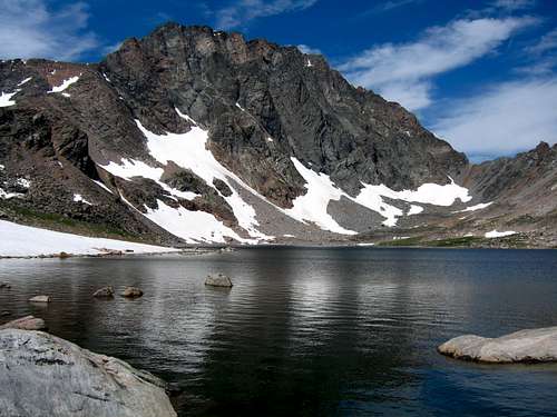
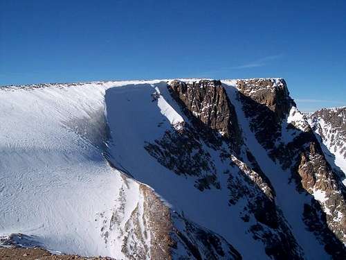
The south slopes snowfield on Spirit Mountain from Shelf Lake
Getting There
Rock Creek Trailhead – From the Montana Road 308 and US Highway 212 junction in Red Lodge, go west on US 212 for 11.4 miles and turn right onto FS 2421 (Rock Creek Road) and measure from this point. Follow this paved road for 0.9 miles where it turns to dirt and passing by three National Forest campgrounds. Here the road forks, take the left fork and continue on the good dirt road and pass the M-K Campground at mile 2.8. Here the road becomes rougher. Continue 8 miles on this road as it drops into Wyoming and reaches the trailhead at the Montana/Wyoming state boundary at 8,700 feet. This road is passable for tough passenger cars with good ground clearance. There are many good places to pull off and camp on either side of the road.
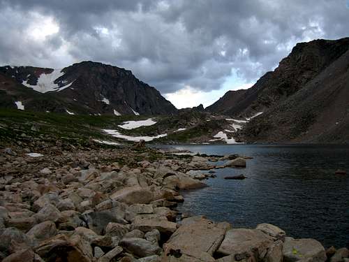
Approach - This is one of the shortest approaches to any 12,000 foot peak in the Beartooth Mountains. From the Rock Creek trailhead, begin up the steep switch-backing trail through an old burn area and reach a nice footbridge crossing Rock Creek after 0.6 mile at 9,080 feet. Cross the bridge and continue up the trail for eight more switchbacks and locate a side trail heading off to the right (north) at 9,230 feet, a quarter mile from the bridge. There may be a cairn here to mark the turnoff. Follow this steep but well traveled boot path along the left(west) side of Rock Creek for 0.35 mile to where it crosses back to the east side of the creek on large boulders at 9,600 feet. Past this crossing, the slope eases and the path continues through open grass above and on the right side of the creek. At 9,850 feet cross the creek back to its left side right below a small tarn and continue up the trail through meadows, passing another small tarn a few minutes later. Just above this second tarn, cross the creek again and follow a small creek which drains Shelf Lake and arrive at the shore of Shelf Lake at 10,200 feet. There is great camping along Shelf Lake but you can continue northwest over a large, broad grassy bench for 1.2 miles to the southwest corner of Moon Lake. This hike is beautiful and the lupines are everywhere in July and August. Awesome camping can also be found all around the south shore of Moon Lake.

Wildflowers on the approach to Moon Lake
Route Description
Cross the Moon Lake outlet stream on a series of rocks and immediately start climbing up the talus and grass slope to the west. This 600 foot slope holds moderate and steep snow in many places well into the summer. Reach the top of this 600 foot slope at 11,000 feet, 0.3 mile from Moon Lake. Continue west up a small valley and contour north at 11,000 feet for 0.1 mile to a very small tarn at 11,050 feet. Walk around its south side and hike up the small headwall for 100 feet reaching a small ridge separating this tarn from Frosty Lake. Contour 150 feet above and to the north of Frosty Lake, cross a small but very loose rocky rib and reach the south slopes permanent snowfield at 11,240 feet. Climb up the snow for 1,000 feet directly to the summit plateau. It starts at about 25 degrees but quickly steepens to 35 degrees for the majority of the climb. The final 200 feet become steep and there is usually a cornice at the top that can be avoided to the right (east) edge of the snowfield on a 60 foot loose rock ridge that leads to the summit plateau (Class 3). Although this will bypass the cornice, beware that the rock is very loose and there is plenty of exposure on the south side to the right. When you reach the summit plateau, walk 0.2 mile east to the highest point at the southeast corner of the plateau.
RT Distance from TH - 9 miles
RT Elevation Gain from TH - 3,600 feet
 Spirit Mountain from Moon Lake | 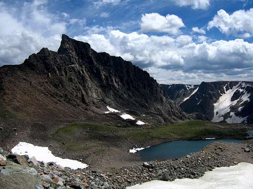 Frosty Lake and Metcalf Mountain from the permanent snowfield | 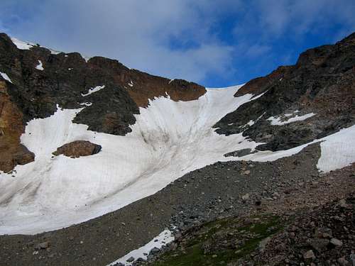 At the base of the snowfield |
Essential Gear
In addition to your standard day hiking or overnight gear, be sure you have an ice axe and crampons as the permanent snowfield can be hard or even icy in late season. Best to ascend this route in June or July for the best snow conditions for both climbing and glissading. This slope offers a great winter/spring ski descent!
Point 12,115 (Drop off mountain) from Spirit Mountain
Map
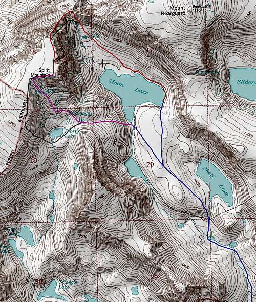
BLUE: Rock Creek/Moon Lake Approach - Class 1
PURPLE: South Slopes standard route - Class 2 Moderate Snow
RED: Northeast Ridge - Class 5.4 or Upper Ridge Bypass - Class 4
GREEN: Dark Moon Couloir - Class 3 Steep Snow
GREY: South Ridge - Class 2+