
-
 7110 Hits
-
 82.83% Score
-
 16 Votes
|
|
Canyon |
|---|---|
|
|
43.84690°N / 103.5664°W |
|
|
Hiking, Scrambling |
|
|
Summer, Fall |
|
|
Overview
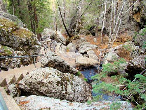 Sunday Gulch Trail View
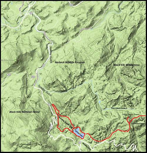
Sunday Gulch is a canyon that originates at the base of the western slope of 6,980-foot Little Devils Tower in Custer State Park. The canyon stream follows a west-southwest course north of the Needles/Cathedral Spires area before it turns northwest just above Sylvan Lake. Below Sylvan Lake, the stream drops more rapidly through large boulder fields and alongside of steep granite walls. Along its course, it passes below 7,000-foot Sylvan Peak and 6,458-foot St. Elmo’s Peak, both to the south. Eventually, the stream is joined by the Lost Cabin Creek on the north and a stream flowing in from the south at Johnson Canyon before it empties into Spring Creek Canyon near the junctions of highways 87, 89 and 385. Sunday Gulch drops 1,200 feet over its 6.5-mile length.
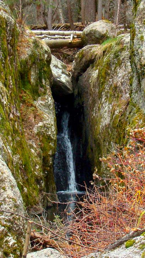 One of many small waterfalls in Sunday Gulch
Almost half of Sunday Gulch is located in Custer State Park. The small stream that flows through the gulch was dammed up in the 1890's by Theodor Reder to form Sylvan Lake. Much of the rest of the land in and near Sunday Gulch is publicly-owned and is part of the Norbeck Wildlife Preserve, the Black Elk Wilderness and the Black Hills National Forest. It’s almost all private property along the gulch from the Johnson Canyon/Lost Cabin Creek junction area downstream to where Sunday Gulch joins Spring Creek Canyon.
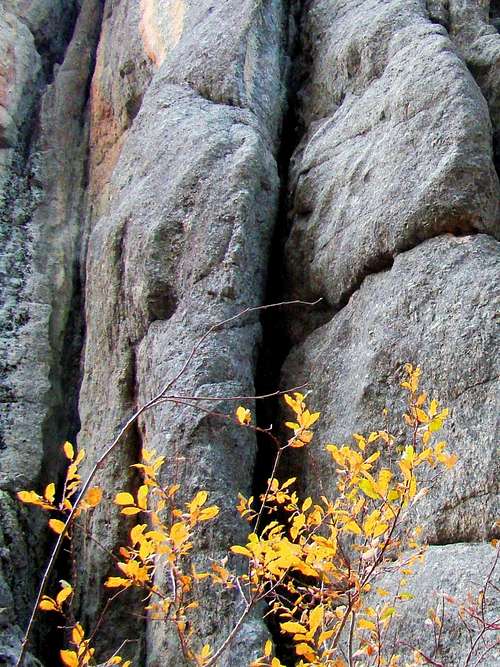
The Sunday Gulch Trail takes hikers through the best of what Sunday Gulch has to offer, which is probably why this is one of the most popular canyon hikes in the Black Hills. The route is so breathtaking that many hikers never realize there is even more to Sunday Gulch. Since the trail is in the core area of the Black Hills, granite formations are the most common feature, with tiny waterfalls and rock grottos in many places. Many of the boulders are covered with moss or lichens. Because of the high steep walls and thick forest in the gulch, there is little direct sunlight on the floor. This factor contributes to the longevity of snow and ice accumulations over the winter and into June, when the trail usually re-opens. Rock climbers are often seen in several locations from the granite spires in the Sunday Gulch Trail area over to the Needles area.
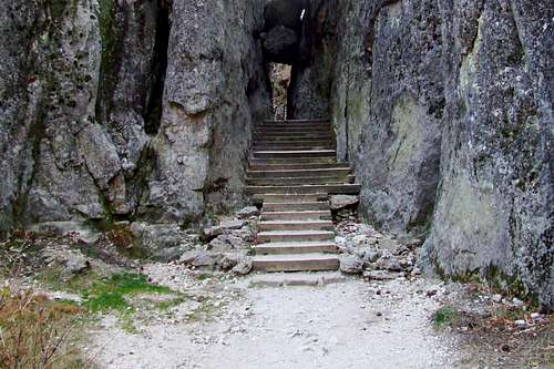 Trailhead or Mines of Moria?
Much of the forest in the area is spruce and ponderosa pine, but there are many aspen and birch along the stream as well as some hardwoods, making this a beautiful autumn hike. Wildlife seen in the area includes deer, elk, mountain goats, bighorn sheep, mountain lions, coyotes, badgers, raccoons, and porcupines. Hundreds of species of birds inhabit the area because of the protective habitat the gulch’s high walls offer.To see all of Sunday Gulch would require hiking Trail 4 from Little Devils Tower to Sylvan Lake, then picking up the shore trail there and hiking over to the Sunday Gulch trailhead. The Sunday Gulch Trail takes hikers to the end of Custer State Park and the western reaches of the Norbeck Wildlife Area. There is no trail down the gulch from there, but the public lands are open to off-trail hiking and the privately-owned land along the gulch can be viewed from Highway 87, as it passes through the lower section of Sunday Gulch to the junction with Spring Creek Canyon.
Getting There
 Narrow Passage on the Sunday Gulch Trail
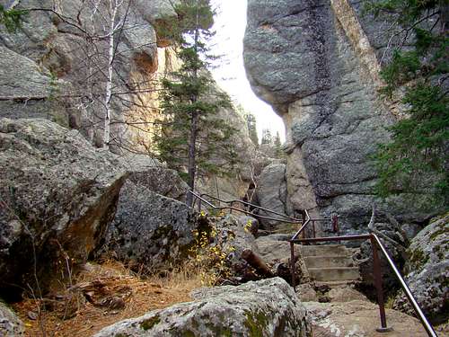 A Narrow Section of Sunday Gulch
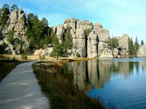
The trailheads are all accessed from Sylvan Lake, which is a few hundred yards from the intersection of highways 87 and 89. Nearby highways include 385 and 16A, and the closest towns are Custer, Hill City, and Keystone. There is a park entry station near the highway intersection, and just beyond the station is Sylvan Lake, with a tourist store, restrooms and cafe. A large parking lot is in front, which is often full in the summer. Hikers often park just across the lake in the larger parking lot that is used by hikers going to Black Elk Peak, Little Devils Tower, Cathedral Spires or connecting trails into the Black Elk Wilderness.
Route Options
 Sunday Gulch Map
The primary trail for exploring the gulch is the Sunday Gulch Trail, a trail that is somewhat unique for trails in the Black Elk Peak - Black Elk Wilderness area. From the trailheads at Sylvan Lake, the trail descends for close to a mile and a half from 6,145 feet to 5,600 feet on the trail’s low point and loops back to the start for a 2.8-mile hike. There is no requirement for the direction of travel on the trail, since trail markers face both directions. Many hikers prefer the clockwise direction because they find the footing to be safer going down the somewhat smoother trail on the western end of the loop, where they do not have to descend as many boulders, but can instead do the boulders going up on the eastern side of the loop. This is especially preferable when the boulders are wet. If you prefer to go the counter-clockwise loop, look for the narrow passage between high granite walls near the dam on Sylvan Lake.
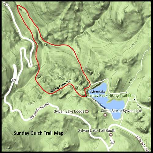 Map for Sunday Gulch Trail
The other end of the loop is about 100 yards back toward the Sylvan Lake Store and behind a large granite outcropping. That trail comes out to a tiny bridge. Both trailheads on the loop are accessible from the 1-mile long Sylvan Lake Shoreline Trail. Blue diamond markers help keep hikers on the right course. The trail is normally only open from June through October. Ice and snow on the boulders makes hiking any other time of the year rather hazardous. Custer State Park rates the trail rated as strenuous.Trail 4 from the Sylvan Lake trailhead follows the upper canyon of Sunday Gulch until the trail begins its steep ascent to the saddle between the Cathedral Spires and the Little Devils Tower. This stretch of trail is about 1.1-miles long and gains about 250 feet in elevation. Most people who hike along here do not associate this section with being part of Sunday Gulch, but it actually is the uppermost part. The Sylvan Lake Shore Trail provides a route between Trail 4 and the Sunday Gulch Trail. The map shows how this 1-mile loop trail connects the other two trails.
Red Tape
To access Custer State Park, you must have either a daily or annual park permit. The park does not allow open fires or firearms. Dogs are supposed to be on leash, but the park does not do a good job of enforcing that. There have been some problems caused by this, so pepper spray is not a bad idea. Camping is only in permitted areas. Please check at the entry station for the latest updated camping information. While some trails remain open all year, the Sunday Gulch Trail is closed in the winter. The park reserves the right to make additional closures as conditions warrant.
When to Explore
 Sunday Gulch Rock Climber
 Wet Trail in Sunday Gulch
The Sunday Gulch Trail is closed over the winter, due to the deep snow and ice that sets in, usually rendering the trail impassable. The Sylvan Lake Shore Trail is open longer, but can also get snowed in, shutting down all trails in the area. So, you will definitely want to stay up to date on the weather forecasts. For the latest forecast and conditions, click on this link:
Custer State Park Forecast & Conditions
If you are uncertain about closures, please call Custer State Park at (605) 255-4515.
Sunday Gulch Area Camping & Lodging
 Sunday Gulch Granite
Custer State Parks offers lodges, cabins, RV sites, and tent sites at a variety of locations. There is a small campground just upstream from Sylvan Lake, along Highway 87, the Needles Highway. You can get more information or call in reservations at: (605) 255-4515 You can also learn more from their website by clicking the park link below:
 The Sunday Gulch trailhead area at Sylvan Lake
The mailing address for Custer State Park is:
Custer State Park
HC 83, Box 70
Custer, SD 57730
For the best in state park lodging, check out the website for: Sylvan Lake Lodge
For more camping and lodging options elsewhere in the area, check out any of the links below:
Maps
The majority of Sunday Gulch lies in the Custer USGS Quad, with a small portion of the gulch lying in the Hill City USGS Quad. The best maps for Sunday Gulch include The national forest service Black Hills Map and the National Geographic Black Hills South Map. Custer State Park also provides free trail maps at their offices.