
-
 57444 Hits
-
 87.75% Score
-
 25 Votes
|
|
Mountain/Rock |
|---|---|
|
|
40.56790°N / 111.6375°W |
|
|
11068 ft / 3374 m |
|
|
Overview

Viewed from Grizzly Gulch
Mount Baldy is the summit capping the north-south ridge which divides Alta and Snowbird ski resorts.
A short and easy approach hike with minimal elevation gain, along with excellent views of the ski resorts and Little Cottonwood Canyon, make this an excellent peak for beginning or intermediate hikers. More advanced hikers can combine this summit with a number of multi-summit ridge scrambles, including the challenging Bullion Divide ridge traverse.
Mount Baldy is located in the Wasatch National Forest.
In nearby Albion Bason to the east of the summit lies Secret Lake. The spelling of Secret Lake varies, with some maps and publications using the alternate "Cecret Lake".
Trails Map showing the various trails in the Snowbird and Alta Ski Resort areas.
USGS Quads:
- Brighton, Utah (1:24k)
- Dromedary Peak, Utah (1:24k)
Getting There
![Looking north from the summit]()
Summit View Looking North
The most scenic approach (and the smallest elevation gain) for a hike of Mount Baldy is by way of the Albion Basin Secret Lake trailhead.
Take the 6200 South exit (exit #6) off I-215 and follow highway 190 south-east approximately 2 miles to the intersection with Big Cottonwood Canyon road. Continue straight through the stoplight and follow the road another 4 miles to the mouth of Little Cottonwood Canyon, where an electronic billboard on the right provides current road and/or weather conditions.
Continue east up Little Cottonwood Canyon approximately 9 miles past the billboard to the eastern end of the Alta ski area. The pavement ends at a well maintained dirt road, which can be followed approximately 3 miles to the Albion Basin Secret Lake trailhead.
Approach via Secret Lake
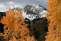
From the trailhead parking area follow the well maintained trail for approximately 3/4-mile to the east shore of Secret Lake. This portion of the trail is very popular and sees heavy foot traffic, especially on early summer weekends when wildflowers are in full bloom.![Mt. Baldy in Autumn.]()
Mount Baldy in Autumn
From the lake follow a faint hikers trail around the north side of the lake, and head for the Sugarloaf ski lift which can be seen a short distance to the west.
Eventually you will intersect a service road which winds its way up to the top of the Sugarloaf ski lift. Either follow the road or proceed directly up the slopes to the top of the lift.
At the top of the lift you will be at a saddle with Sugarloaf Peak to the east and Mount Baldy to the west.
From the saddle follow an unmaintained trail up the south-east ridge to the summit. The ridge is steep at times but no scrambling is involved.
Round Trip Hiking Distance: 4.0 miles
Elevation Gain: 1,658 ft.
Trailhead Elevation: 9,410 ft.
Summit Elevation: 11,068 ft.
Red Tape
There are no fees for entering Albion Basin or parking at the Secret Lake trailhead.![Heading up the west ridge...]()
The West Ridge
The dirt road from the Alta ski area to the trailhead passes through areas of privately owned cabins and property. Be respectful of the local property owners, and observe speed limits and parking restrictions - park only in designated areas.
When To Climb
Anytime in spring after closure of the ski resorts, through late fall.![Skiing the Main Chute in November]()
November Skiing
Significant snow remains in the area well after closure of the ski resorts. Early season hikes may require the use of snowshoes.
Camping
Camping is permitted in the Albion Basin campground, located at the Secret Lake trailhead. The campground contains 26 designated sites, available on a first-come first-serve basis. Campsites can also be reserved in advance by phone at 1-877-444-6777.
Mountain Conditions
- Albion Basin Webcam.
- National Weather Service forecast for the area.
- Utah Avalanche Center website.


