Overview
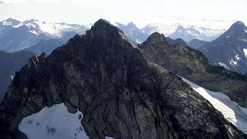
![Dumbell Mountain]() The north side of Dumbell Mountain from Greenwood
The north side of Dumbell Mountain from Greenwood
Though I have very little true climbing and alpine experience, I have taken on the seemingly daunting task of becoming the youngest finisher of the Bulger list, a list of the 100 highest peaks in the state of Washington. I have about 3 years to do this. If I am somehow able to achieve this, I would also destroy the current record for time taken to finish this list by over a year. I began at the end of June 2015, climbing Hoodoo Peak to start. Since then, I have done quite well, summitting 6 more over the month of July. It has been at times a struggle, but I am quite amazed at the amount I have accomplished and everything I've learned.
After doing my research, I decided that I really needed to get some decent scrambling in and get used to dealing with exposure, and that Dumbell Mountain would be the perfect introduction for me. The route up was said to be class 3, with some decent exposure near the summit block, giving me a healthy dose of scree and talus as well as some larger stuff I'd have to climb up or around.
On Monday July 27, I set off on my quest to climb Dumbell and Greenwood Mountains, which would be Bulger numbers 6 and 7 for me. My plan was to climb both peaks in a single day, a first for me. Going in, I was expecting a challenge, but the challenge I got ended up being way more than I had expected.
Starting Off
On Monday, after I got off work, I packed my gear up into my car and headed southeast toward the Entait mountains near Lake Chelan, WA. After a long drive and miles of rough gravel road, I arrived at the Phelps Creek Trailhead. When I arrived, it was long after dark, so I climbed in the back of my car to get some much needed shut eye.
After a surprisingly good night's sleep, I awoke to a glorious day, got dressed, cooked a hearty breakfast and was on the trail by 6:45. The Phelps Creek Trail is a lovely, easily followed trail that follows the Phelps Creek about 6 miles. Remember when I said the road to the trailhead was rough? The Phelps Creek Trail is wider than that road.
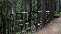
![Scenery of Phelps Creek Trail]() Scenery along the trail
Scenery along the trail
For the first 6.5 miles, this popular trail was flat and woody with many small creek crossings, and one larger crossing at Leroy Creek. In the spring, most of these small crossings are actually quite large, but in late July after a winter with little snow, you can cross each creek without getting your boots wet. At 6.5 miles, you enter the picturesque Spider Meadow, a lush mountain meadow with abundant views and great campsites.
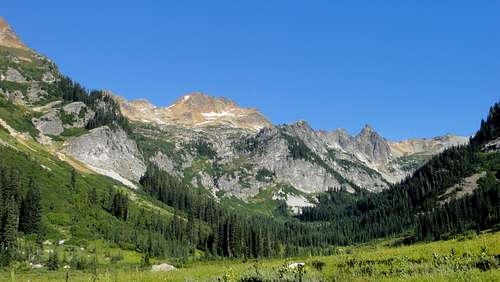
![Spider Meadow]() Looking up the Spider Meadow from the South end
Looking up the Spider Meadow from the South end
A half mile later, I found a great place to camp at the north end of the meadow. It was calm, private, and near water, which pretty much meets my criteria for a perfect campsite. I dropped my gear, pitched my tent, and readied myself for the ascents. By 10 am, I was on my way to climbing Bulgers 6 and 7.
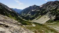
Phelps Basin
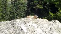
Upon leaving Spider Meadow, the trail splits. Follow the trail to the West and you can climb up to Spider Gap for some, apparently, great views of the Lyman Glacier on fellow Bulger Chiwawa Mountain. Following the trail to the east will take you back to the Phelps Creek and lead you up to its drainage basin at the base of Dumbell Mountain. You can follow a trail most of the way through the basin. There were many marmots here. I surprised a few, also giving me a jump, before I figured I'd be nice and make sure I made enough noise to alert them an intruder was entering their neighborhood.
![Resident of Spider Meadow]() One of the many marmots of the Spider Meadow and the Phelps Basin
One of the many marmots of the Spider Meadow and the Phelps Basin![Phelps Basin]() View looking down the Phelps Basin from the slopes of Dumbell Mountain
View looking down the Phelps Basin from the slopes of Dumbell Mountain
By the time the trail was no longer evident, it was pretty obvious where to go next. There were pretty much two ways to go, up a loose, miserable looking talus slope to a mostly absent snowfield, or follow the drainage to the base, climbing up a couple gentle waterfalls along the way. By the time I reached the top of the waterfalls, the view of the lower basin had opened up quite a bit making me want to turn around every few minutes and taking it all in. After reaching the very north end of the basin, I stopped to drink some water, collect my bearings, and establish a plan.
Dumbell Making a Dumbbell Out of Me
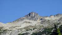
This is the point where things start to get interesting. While sitting below the ridge, I had two peaks in front of me. One due north, and the other to the northeast. I had been looking at the peak to the north assuming I could see Dumbell Mountain throughout the entire basin. This northern peak looked similar to a picture of the summit block I had seen here on summit post minus one thing: a snowfield. My thinking was, this is late July of a fairly hot summer after a winter with record low snowfall. Obviously that snowfield has all melted, right? Looking at the map, Dumbell appeared more to the east. But the shape of this northern peak looked more similar to the picture I had seen online than the northeastern peak did, so I made the snap-judgement to not follow the map. From here I headed up the creek toward the ridgeline aiming just east of the peak.
![What I initially thought was Dumbell Mountain]() The peak I thought was Dumbell Mountain
The peak I thought was Dumbell Mountain
Heading up toward the ridgeline was easy. Easy class 2 with rock that was fairly solid. I could walk up most of the way. The views to the south were great. Red Mountain and Phelps Ridge towered over the valley. Going higher opened up views of other much higher peaks and various glaciers and snowfields popped in to view. About 150 vertical feet from the ridgeline I stopped to do some route planning. It was here I realized I had been aiming toward the wrong peak. The peak I had aimed for was definitely not a scramble. It had shear cliffs that most people would only attempt with a rope and lots of climbing experience. To the east, the peak I decided wasn't Dumbell was noticeably taller. Well shoot. Should have trusted the map.
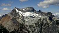
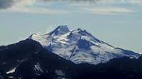
![Bonanza]() Mount Bonanza from the ridge west of Dumbell Mountain
Mount Bonanza from the ridge west of Dumbell Mountain![Lyman Glacier]() Lyman Glacier from the ridge
Lyman Glacier from the ridge
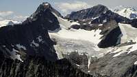
I continued up toward the ridgeline, heading toward Dumbell. I crossed a small snowfield and gained the ridgeline. The views north of the ridge were spectacular. Bonanza towered across the valley with miles of the North Cascades as a backdrop. Turning around, and Chiwawa and Fortress Mountains were in full view, with a cloud covered Glacier Peak behind them.
Scrambling along the ridgeline I reached the base of the summit block and began going up. This was difficult like no scramble I'd done before. This was more vertical climbing than the more horizontal crawling I was used to with my past climbs. The exposure was also new. I knew that a fall would result in a tumble down the scree slopes before and likely a trip to the ER. Still I climbed, eager to get to the top. My route finding abilities were tested, and many times I had to change my plan because I either couldn't reach a ledge or found a spot where everything I tried to grab was loose.
At long last, I reached the top. "Whew, that was fun," I thought to myself as I began looking for the summit register. It was nowhere to be found. Then I looked up. Looming above me was another peak. At first I thought it was Greenwood, but then remembered that Greenwood was shorter than Dumbell and this one was definitely not. I looked over the edge to the east at the slopes of this other peak. To my frustration, I immediately recognized the snowfield at the bottom of the summit block from the same picture of Dumbell that I confused earlier. Turns out, I had just climbed a lower sub peak of Dumbell. Ugh!
After taking a sip of water, I began down climbing directly down toward the West side of the summit block. This was a mistake. I wasn't anywhere near mentally ready for the exposure or class 4 or maybe even class 5 rock that this face had. About half way down, I thought about going back up and climbing down the other side, but realized that might be even more tough.
About 20 feet up from the bottom was a cliff. Someone had fixed some webbing for a repel, but it was long since in need of replacement and I had no rope to repel with anyway. So I down climbed that as well having to let go about 8 feet the bottom and hope I could land with grace at the bottom. I made it and began climbing toward the true summit. The climb up the summit block was the easiest climb I had done in the last half hour. After 5 minutes of climbing exposed class 3, I reached the summit. What a feeling and what a view.
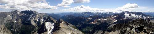
![Panorama to the South of Dumbell]() Panorama to the south from atop Dumbell Mountain
Panorama to the south from atop Dumbell Mountain
After eating lunch, signing the register and taking numerous pictures I began heading down. The ledge to get to Greenwood Mountain was at a notch along the east side of the summit block. Rather than heading down the way I came up and scrambling around the summit block, I opted to straight down the east face to the ledge. This was another mistake, though not a huge one. More exposed class 4 scrambling. For the most part this was easier, though the scariest part of this whole ordeal occurred on this portion.
About half way down I was making great headway. It was tough, but I was doing it, and feeling great about it. Feeling with my feet, I found a rock wedged between two boulders that felt pretty solid. I stepped down on to it, then proceeded to climb past it. I grabbed that same rock with my hand, and suddenly it began to move! I panicked and flailed my arms about, almost falling, but barely catching myself with a different hold. Looking down, a fall would have certainly lead to some serious injury for me. The hold I caught wasn't very good and I awkwardly struggled to find something else and continue my way down. At last I made it to the ledge and proceeded to Greenwood.
Greenwood Mountain
Going up Greenwood was a lot smoother. I headed on the ledge around the northeast face of Dumbell. This was one of my favorite parts of the day. I had great views of the Fernow Group. Looking down there was a good drop to a snowfield below. Above was the slabby northeast face of Dumbell. Making it across the ledge, I made my way down a very loose talus slope to a small glacial lake between Greenwood and Dumbell. Greenwood was a very easy and very uneventful class 2 climb all the way to the summit.
![Glacier Peak From Greenwood Mountain]() Glacier Peak seen from Greenwood Mountain
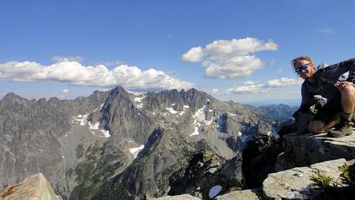
Glacier Peak seen from Greenwood Mountain![Entiat Cirque from Greenwood Mountain]() Me on Greenwood Mountain with the Fernow Group in the background
Me on Greenwood Mountain with the Fernow Group in the background
The views were incredible. Bonanza looked huge across the valley. The Wolverine Creek fire was small and only hours away from blowing up in to a cloud of smoke seen all the way from Seattle. Glacier Peak no longer had clouds around it and was framed by Fortress and Chiwawa mountains. You could see many miles of nothing but towering mountains and snowcapped peaks.
More trouble going down
Going down Greenwood was easy. By this time I was a little sore and had decided that my 8 year old boots were needing to be retired soon. It was a well packed talus slope making it really just a walk down. Going back up the loose talus towards the Dumbell ledge was a struggle, but nothing I couldn't handle. It was so loose that for every 2 steps up I took, I slid back down 1.5 steps. It would have been nice to have had my ice axe because the snow field next to the talus would have been a bit more enjoyable to climb up.
After making it up the talus rubble, I walked around the ledge and downclimbed from the notch on Dumbell with a little exposure to the long talus slopes back toward Phelps Basin. It was mostly a walk down to where the creek started. About half way down, you could hear the creek travelling through the rock below your feet, but couldn't see any water. I began seeing some rock stack trail markers and tried to follow them down, though they were too spread out to really be all that effective. Nevertheless, I did my best and continued to follow them. After finding 5 or 6 I came to another. Looking around I couldn't see the next stack, but too my left and right, it looked a bit cliffy to get down to the streams flowing either direction. Straight ahead it was mostly vegetated, but there was a somewhat clear path carved by water flow down toward some trees. I figured that this must be the way to go and went straight.
By the time I made it to the trees, the path I was following was no longer clear, but the trees were sparse enough that I could walk through them. After travelling through them about 30 feet, the slope was suddenly vertical. I couldn't see through the trees to the bottom, but the cliff was manageable by grabbing hold of tree branches and downclimbing. I went down another 50 feet when suddenly the trees stopped and I found myself at the top of a 50 foot cliff dropping down to the top of the Phelps Basin.
At first I decided I could manage the downclimb, but realized very quickly that this wasn't as easy as I had thought. I'm stubborn and am someone that will do anything in my power to avoid turning around. I took a couple breaths, looked back at the basin, then looked down the cliff trying to find a route. I noticed to my left the cliff wasn't as tall so my goal was to make it that way, but to get there my only route was to climb down and to the right before I could gain a hold that took me left. Being confident that my route planning was correct I followed my route all the way to the bottom, glancing back up at what I just climbed down.
Now I was back to the basin. I made my way down the drainage and made it back to camp over the next 30 minutes where I cooked dinner and passed out in my tent sleeping long and hard until morning. By 10 the next morning I had packed up and left camp back to the car. On the way home, I stopped at the 59er Diner, enjoyed a great handmade veggie burger and a milkshake; a great way to finish the trip.
Conclusion
What was supposed to be my first real dose of class 3 exposure, ended up being my first dose of upper class 4. There were multiple times where negative thoughts took over and I was sure this was the end for me or that I would never climb again. Reflecting back, this was a good thing. If I really want to climb mountains, I have to accept that I might fall. It is a dangerous sport, but a lot of the fun of climbing is that you are vulnerable. The thrill of the exposure was incredible. I realized that I don't enjoy climbing for the pictures, views, or bragging rights, I enjoy it because it is dangerous, uplifting, and both physically and mentally challenging.
This trip taught me more than any other backcountry experience I've ever had. Going through boy scouts I was always told to listen to the map, but I never really learned to. I was never in a position where there might have been serious consequences from not looking one. Ultimately I was never in an place where I needed one because I was always on trails that were easy to follow. This time however, if I had listened to the map, my day would have been a whole lot easier. I learned that I shouldn't be as stubborn and that the map is more likely to be correct than I am.
In the end, I am glad this trip went both so wrong and at the same time so right. I know that physically, I am capable of taking on anyone of the Bulgers. I know that any situation I find myself in, I am more than capable of getting myself through based on my physical ability. I also learned that mentally, I have a long ways to go and a lot of stuff to learn before I can conquer all the peaks I aspire to climb. I have had my doubts this past month, but the only thing that is actually limiting me is my mind. I look forward to my next summit and hope that I can take as much from it as I did from climbing Dumbell and Greenwood mountains.


Comments
Post a Comment