Adder Mountain Trip Report: May 25/26 2007
If you like your trip reports to describe well-frequented routes, unlimited views and contain award winning photos, this isn’t for you.
If, on the other hand, you appreciate problem solving in the mountains, a summit won in difficult conditions and, above all, the challenges presented by navigation in limited visibility, then read on.
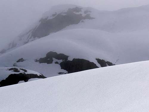
![Summit Ridge from 500m]() The very best view we got of the summit
The very best view we got of the summit |
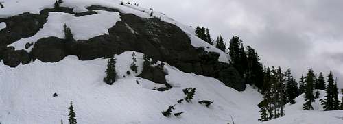
![Adder Mountain North Face]() What we should have seen. The summit ridge in better weather.
What we should have seen. The summit ridge in better weather. |
My first time on Adder Mountain was in late May 2006. Others familiar with the terrain led the trip at that time and, as one does, the tendency was to let the experts lead the way and just plod along enjoying the scenery. Not that there was that much scenery after a while anyway. The clouds moved in, visibility went to near zero and the trip leader called it after just 3 hours or so. Nevertheless in that short time I’d seen a lovely forested approach on perfect-for-step-kicking snow, a wide-open alpine ridge and what looked like the prospect of a nice easy summit to add to my Island collection. I didn’t worry at all about turning round early because I was for sure heading back there the next week to bag this one. Two days later I tore my right medial meniscus and was plunged into the nightmare of what masquerades as a health care system in BC. When I finally emerged, repaired and rehabilitated, the summer season was just about over except for a few local hikes around the immediate Victoria area where I live.
Never one to leave anything half-done, Adder Mountain was naturally first on my list for 2007.
![Route Start from above]() View back to start point
View back to start point![Top of the Approach Road]() Start point camp
Start point camp
Early May reports from Alberni valley locals spoke of huge summit cornices above the north face – our chosen route – as well as limited logging road access because of snow at low levels. We therefore put our original May 12/13 date back a couple of weeks and waited for the sun to ease the way a little. When we eventually drove up on the evening of May 25th it was to find the approach roads clear of both snow and deadfall all the way to the highest point where the route begins.
On Vancouver Island we have a love-hate relationship with the logging companies. We hate what they do, but we love those roads that they build up towards the alpine, easing access as they do. I wish they could just build the roads and leave the trees. But we’ve got to keep all that junk mail coming right? Be all this as it may, the evening of May 25 saw my buddy Graham and I happily camped at the top of the approach road, my favourite cello concerto on the truck stereo and bedtime drinks in hand. VERY civilised trip this one!
If there’s one absolutely functionless occupation on Vancouver Island (after government of course) it’s that of weatherman. The open Pacific is just a few kilometres away to the west, the coast range mountains and fiords with their notorious outflow winds are equally close to the east, the island is more mountain than flat land, systems swirl and whirl around continuously, and here some idiot is trying to say what the weather is going to do. On this occasion the idiot promised us scattered clouds and a 40% chance of showers. Being idiots ourselves we naturally listened and believed.
After a lovely sleep in the comfort of my truck, we were up at 5.15 and off about 6.30. Far from “scattered” clouds the clag just a few metres overhead looked remarkably un-scattered to me.
![Negotiating Stream Crossings]() Negotiating a melted out stream
Negotiating a melted out stream![River Climbing]() Tricky river crossings
Tricky river crossings
The first half hour of the route up through the forest was nice and straightforward. There’s a sort of boot-path and plenty of flagging. As is so often the case, the clouds had not penetrated the trees to this point. We reached snow after less than an hour. Nice and consolidated, lovely for step kicking and only occasionally steep. It soon became apparent, however, that there was much less snow at this elevation than at the same time the previous year. The many braided streams flowing down the valley we were climbing were open and it was necessary to cross and re-cross them continuously. This entailed climbing up and down the 2 metres or so vertical snow walls carved out by the flowing water. We only found one snow bridge in place and that was at the highest point before reaching the alpine. At least we had uninterrupted visibility to this point.
After about an hour and a half, the valley had narrowed, we were faced with rock bluffs ahead and it was clearly time to exit the valley to the west. A bit of steep snow, the trees thinned abruptly, the wide north ridge opened above us and then promptly disappeared as the clouds came down.
![Tricky Bluffs]() Pass these bluffs to climber's right
Pass these bluffs to climber's right![Passing the bluffs]() Descending around the bluffs
Descending around the bluffs![Exiting to the Alpine]() Traversing around the bluffs
Traversing around the bluffsImmediately to the west of our exit point from the trees, we were confronted by a series of rock bluffs partly covered by snow. These same bluffs must have confronted us in 2006 but I had no recollection of them – serves me right for not paying attention. We were not carrying any gear with us and so were forced into an end run to the right (north) of the bluffs on steep snow and using trees for aid. A single flag on one of the “aid-trees” told us that folk had gone this way before. Which was a good job since we’d seen the last route marking over an hour previous to this. We were now on the north ridge proper and with it went the last vestige of any visibility.
At this juncture the north ridge is several hundred metres wide from east to west. Navigating it in 10 metres visibility was by map, compass/GPS and intuition. Fortunately, Graham is blessed with an over-abundance of the latter and we made steady progress recognising terrain features from the map (or convincing ourselves that we did) and with occasional glimpses ahead as the murk thinned momentarily. The map clearly showed that the ridge narrows right down as it begins to approach the north face proper, so as long as we kept pointing uphill while heading south, logic said we should be fine. And so it proved. About 5 hours from the start (it should be more like 3 in good conditions) the route steepened noticeably and we began to come across what was obviously cornice debris. So at least the cornices had
started to fall off then!
![The Open North Ridge]() The wide open north ridge
The wide open north ridge![Peering into the clag]() Where to from here?
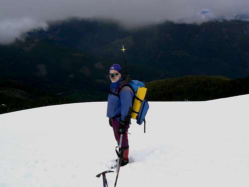
Where to from here?![Below the cornice line]() Martin below the cornice line
Martin below the cornice line![Graham on the summit]() Graham on the summit
Graham on the summit
Proceeding up cautiously we were eventually blessed with enough clearing to make out a vertical shear line ahead and to assure ourselves that the cornice line along the summit ridge had either completely fallen off, or damn close to it. We had, however, no way of discerning how high the shear line was, how far above us it was and if there was any point at which it might be climbed.
At first we tried to traverse to climber’s left, underneath the higher east summit. We soon ran into some pretty scary looking bluffs with a nice moat underneath them. At least the clag spared us any view of the run-out below. Backing off, we traversed back west and down. Another momentary clearing revealed the shear line again and this time we made a beeline for it. It proved to be only about 20 metres above us and only 3-4 metres high. The murk had distorted distances to the point where everything seemed to be ten times further and higher.
Nevertheless, a 4 metres vertical wall of snow is still not a straightforward proposition with one ice axe each, no gear and an unseen run-out below. So we traversed west some more and were duly rewarded. At a point just to the east of the west summit, the shear wall had briefly reduced to a height of 2-3 metres. Kick two big steps, step up, sink the axe over the top into the flat ridge crest, heave over the top and it was done. All that was then necessary was a gentle 5 minute stroll along the summit ridge. It had taken us nearly 90 minutes to solve the last 30 vertical metres. Something that would have taken 5-10 minutes in normal conditions.
The high point was probably not where it normally is. I’m told that there is a summit cairn and register but both were well buried somewhere in the vicinity. Nevertheless we tagged the highest point we could without crossing the cracks guarding the edge and settled in for lunch.
An interesting phenomenon on the way along the summit ridge is worth recording. As we were walking along, I suddenly just toppled over. I didn’t trip over anything (as I often do) I simply just fell over. The clag was so thick, my brain had become unable to distinguish up from down. So to reestablish equilibrium, as it were, it placed me in a horizontal position in order to get its bearings. The climber in me was a bit unnerved by this but the scientist I once was found it quite interesting.
After enjoying the views of the juniper bushes 10 metres north of the summit for a while we set off down at 1.30pm. Other than care downclimbing the cornice shear line and the steep snow around the bluffs, this passed uneventfully. We even dropped out of cloud just before entering the trees and got some views right down to highway 4. The one useable snow bridge in the forest was still there but noticeably more bowed. It had one or two more days to go before it too collapsed we thought, adding one more tricky river crossing.
![View down to highway 4]() At last a view! Graham on the lower N ridge; Sutton Pass below
At last a view! Graham on the lower N ridge; Sutton Pass below
We got the car at 5.15 and a couple of hours later it was pizza and beer time.
A great trip with a great mate.
Adder Mountain in summer is regarded, quite rightly, as a “somewhat strenuous scramble” in our local grading parlance. This trip was a bit more than that. Not a shred of a summit view to be sure but there are other things we can take from our all too brief visits to the high places. Companionship, the satisfaction of problems met and overcome, a safe return and, above all, the joy of simply being there.
Page Visitor Statistics

Comments
No comments posted yet.


 The very best view we got of the summit
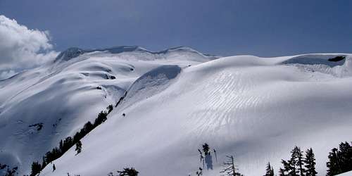 What we should have seen. The summit ridge in better weather.