INTRODUCTION TO THE CLIMB
The first time that I climbed Finsteraarhorn (4.273 m.), in summer 2001, the highest top in Bernese Alps (Switzerland), I was captived by a lonely and neighbouring mountain: Aletschhorn (4.195 m.). It's a superb and remote summit, the second in height in Bernese Alps, surrounded by huge glaciers and protected by the biggest glacier tongue in the Alps: the Grosser Aletschgletscher. This large "ice river" extends more than 14 kilometers from Konkordiaplatz, where several glaciers that flow from famous peaks like Jungfrau (4.158 m.), Mönch (4.107 m.) or Fiescherhorn (4.048 m.) join. Other glaciers close the access to Aletschhorn by the south and west: Oberaletsch glacier, Mittelaletsch glacier, Lang glacier, etc.
The result is a wild mountain, in an Himalayan environment, difficult even in its access. -I'll climb that mountain sometime- I said myself at that time in the top of Finsteraarhorn, one of more impressive summits in the Alps.
I began to investigate and discovered an unfrequented route by the south-east side of Aletschhorn; this route was an interesting variant to the south-west normal route, where you can sleep in the guarded hut of Oberaletsch. I read that some mountain skiers choose this route (by the south-east side) to ascend Aletschhorn in spring, when there is a lot of snow still in the Alps.
I thought then that this route would be easier than the south-west side, and my mountain books confirmed it: "PD by the south-east side, crossing the Mittelaletsch glacier and getting to the top by the NE ridge, passing Aletschjoch" (the south-west side route is AD-).
By the south-east side route we'll have to cross two glaciers to get to the Mittelaletsch hut, an unguarded shelter lost in the middle of the upper part of the Mittelaletsch glacier: a remote site, without a doubt.
Not much information about this shelter: 13 places, 3.013 meters height, property of SAC (Swiss Alpin Club), no guard... but: is there water disponibility close to it in july or it will be indispensable melting snow to drink? It will be necessary take sleeping-bag or there will be air beds and blankets? It will be a crowded hut in July?
Another unknown factors were about the access: where to start to cross the wide Aletsch glacier?, It will be marked with little flags (like other glaciers in the Alps) the two kilometers crossing through a hard ice and deep crevasses?
No more questions... it's time to start the adventure!
FIRST DAY: Fiesch (1.089 m.) - Fiescheralp (2.212 m.) - Vordersee (lake) (2.347 m.) - Marjelensee (lake) (2.300 m.) - Grosser Aletschgletscher (glacier tongue) - Mittelaletsch glacier - Mittelaletsch hut (3.013 m.).
Diego and I leave behind the village of Fiesch a hot day of July; we take one of the first cable-cars to Fiescheralp (2.212 m.), where we get in less than 10 minutes, going-up steep slopes covered by firs (Picea abies). The upper limit of this forest is Fiescheralp, a crowded ski-resort in winter, but a quiet joint of wood houses and restaurants in summer.
Meadows full up of wild flowers replace to firs: only distant cowbells broke the silence in this privileged landscape. Our rucksacks are full: climbing material, ice-axe, crampons, rope, lot of food... We start the way to Aletschhorn, walking by a wide path, suitable to cars, that skirts to the north by a zone named Fiescheralpe in the swiss map. We arrive to the entrance of the tunnel (Obers Tälli), located at a height of 2.335 meters, close to some old log cabins, partially ruined. They are built in stone and wood (the roofs) and perhaps were used by shepherds.
The tunnel crosses a big stone wall (Talligrat) and has a length of more than one kilometer. It's lighted by fluorescents and you can see an image of the Virgin, surrounded by candles in the centre of this dark place. To the other side of the tunnel, we discover the Vorder lake (Vordersee) on the right, with a dam and a wood shelter: the Gletscherstube, that is a restaurant too. On the left, the ice appears in the background: the Aletsch glacier is like a gigantic ice river. The Himalayan ambient is obvious: even several little Tibetan prayer flags wave, touched lightly by the breeze.
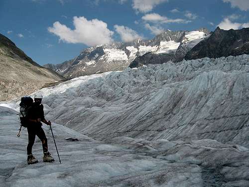
We follow the well marked path to the west, going down in the direction of the lake Marjele (Marjelesee or Marjelensee), located at a height of 2.300 meters, close to the blue ice of the Aletsch glacier. The path continues skirting the north face of Eggishorn (2.926 m.), but we have to reach the glacier tongue, so we follow several cairns that bring near to the glacier. Stones are polished by the ice and it's difficult to find an easy place to reach the frozen surface. Crampons are useful in this hard ice, where the crevasses seem like ravenous mouths.
The magnificence of the Aletsch glacier is difficult to explain. It's like a frozen labyrinth, with its own climate: are we into a fridge-freezer? No, but the difference of temperature is amazing! We have to keep warm with our polar fleeces. We decide look for a way between deep crevasses, rivers on the ice that finish in dark holes and moraines that punish the crampons with thousands of stones of different sizes. The glacier is like a rough sea, where high waves force to going up and down constantly.
-Two kilometers... 40 minutes - I said ingeniously before to get to the glacier. We occupy more than one and a half hour really to cross the Aletsch glacier! Near to the other side, stones cover completely the surface of the glacier, and we have to take off the crampons. In this part of the glacier, contrary to the other side, the deposit of materials (stones and slime) is evident: a glacier is very similar to a river. We walk on this slime, that remember to quicksands or even to the sand of a beach.
The glacier has excavated a pronounced slope during hundred of years. The advance through these unstable slopes is very difficult: lot of big stones threaten falling off. No cairn marks the way, but the stream that rises at the end of the Mittelaletsch glacier is near: we can't see it, but we hear it clearly.
We have troubles: it's impossible keeping balanced on these loose stones and we fall to the ground several times in spite of our trekking poles.
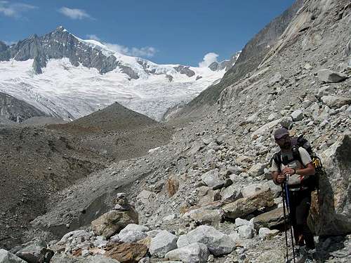
We arrive as far as a esplanade where we found a lonely cairn. Grass, multicolor flowers and even some dwarf willows convert this pleasant place in an oasis, surrounded by vertical walls and huge moraines. The stream that fall from the close Mittelaletsch glacier has opened a colossal hole in the ice of the Aletsch glacier. The flow is imposing; impossible crossing to the other bank: it's like an Himalayan river!
We find remains of a path, marked by cairns, that skirts the valley in "U", where the glacier has disappeared recently. Lot of rocks and remains of avalanches cover the way to the glacier and we don't see more cairns. We are afraid of get lost, especially when we reach a spot where several big polished walls threaten to close the valley.
In 1850, the ice level of Grosser Aletschgletscher and Mittelaletschgletscher was 100 meters above, and it's visible a line that marks surely that upper level. Even those glaciers were join at that time; today (2006) are completely separated.
But we found a pass between that big stones and the ice of the Mittelaletsch glacier appears in the background. It's completely covered by rocks: it looks like to the surface of a strange planet and we are like astronauts prepared to explore it!
The glacier is plain at this point and it's easy to walk on this frozen surface, avoiding the rocks.
2.650 meters height: it's time to decide how to get to the visible (but still very distant) Mittelaletsch biwouak. The shelter is placed on the right side of the Mittelaletsch glacier, on a 300 meters polished stone wall, seemingly impregnable. The glacier has a bad aspect: lots of seracs and crevasses cover its surface and we don't know if it will be possible to find a way to avoid the crevasses in its upper part.
We don't see any cairn and we decide to try by the glacier. The slopes increase and some crevasses appear, so that we have to use the rope. We avoid several threatening seracs by the left, looking for a pass to the right, where the slopes are less steep and the glacier is plain.
It's like a labyrinth of ice! We have to go by an indirect route, avoiding lots of crevasses, some of them covered by a very dangerous soft snow. But we are now in the correct direction, and the Mittelaletsch hut is near. We leave the glacier and a lonely cairn appears between polished rocks that guide to the shelter.
The Mittelaletsch hut is an hexagonal building and there is no people inside: we are alone in tens of kilometers around!
We have good news: there is a stream near to the hut. It will not be necessary melting snow to drink!
SECOND DAY: Mittelaletsch hut (3.013 m.) - Aletschjoch (col) (3.614 m.) - NE ridge (3.718 m.) - secondary summit (about a height of 4.060 meters) - return to Mittelaletsch hut.
All the windows are opened, waiting for the light. The sunrise gets quietly. I look outside of the hut and the weather is worrying: it's a hot day, even at those early hours in the morning.
-The snow will be very soft- I think worried. There wasn't a frozen last night.
Yesterday, we spend more than ten hours to arrive to the Mittelaletsch hut.
We are very tired and there are still 1.200 meters to the top. If the snow is in bad conditions we'll need more time to ascend, and perhaps the climb becomes very hard and dangerous.
We look for distant footprints on the snow of the glacier, 100 meters on the hut, that guide surely to the Aletschjoch (col), where we'll take the NE ridge, the way to the summit. The place is complex: polished rocks and thousands of loose stones difficult the ascent. Fortunately, the snow is hard for the moment .
The last people that crossed this glacier was a week ago, according to the diary of the Mittelaletsch hut; so the majority of footprints are rubbed out. Are we in one of the main mountains in the European Alps or in an unknown summit in the Himalayas? We are completely alone and the solitude is imposing.
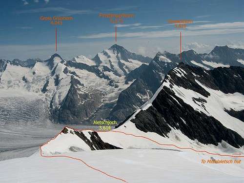
We arrive to the Aletschjoch, at a height of 3.614 meters: an impressive place where a sharp ridge appears in the way to the summit. We can see finally the other slope of the mountain: no word can explain the magnificent of this wild environment; snow and ice dominate the scenery: it's like to return to the last glaciation. It will come this way the strange mouse of the movie “Ice Age”, looking for desperately its acorn?
We surprise with the nearby tops of Jungfrau (4.158 m.), Mönch (4.107 m.) and Eiger (3.970 m.)... and specially with the superb Finsteraarhorn (4.273 m.), the highest top in Bernese Alps.
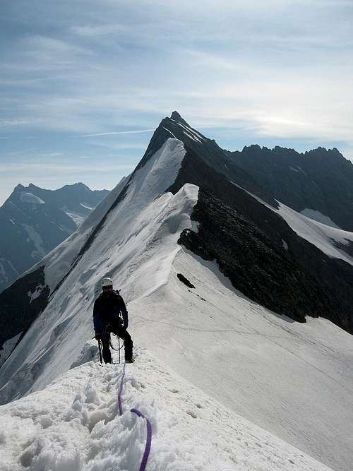
We begin to cross slowly the ridge, because of a 700 meters fall to the north face, that ends in the Aletschfirn glacier. At the back of it, Konkordiaplatz is the junction between this and other glaciers. I read that the depth of ice at this point is about 900 meters!
Deep footprints remain on the snow, but the ridge is only 40 centimeters in width: no possibility to get lost. On the right, 700 meters of precipice; on the left, only 400... We have to walk very concentrated; sometimes the soft snow sinks and we can lose one’s balance!
I know that we have to do if someone falls by one of the slopes... the other should to throw to the opposite side and trust in the rope!
A rocky section interrupts the snowy ridge: it’s like a knife and our crampons creak horrifying, whereas we continue the advance in silence. -There’s no wind, at least- I think.
After this 3.718 meters height on the ridge, the snow appears again: this sharp ridge never ends! I can’t believe that this route was frequented by mountain-skiers... When we arrive at the end of this snowy ridge, sweating plentifully, a long 300 meters slope, that increases progressively, separates the ridge and the secondary summit (4.087 m.) of Aletschhorn. The main summit (4.195 m.) is at the back, seemingly near.
But the climb gets complicated: the snow is in very bad conditions and we sink the legs in it down to the knees. The advance becomes still slower, but we win several meters to the mountain, spending our forces desperately. After an eternity we reach the visible rimaye in the upper section of the secondary summit.
I begin the climb of this steep point, and cross undoubtedly the rimaye, that presents dark hollows. My ice-axe penetrates down to the cross, and more again! The snow is very soft and the footprints continue skirting the north face of this secondary summit. We are about at a height of 4.060 meters. The fall is important to the north face, and Diego thinks that the safest thing is to come back. I secure him with the rope and my ice-axe, but he's afraid of the descent.
The mountain conditions have won! We return sadness to the ridge, enjoying the wonderful landscape and the impressive mountains around us.
-We will be back another time!- we think; but I know at this time that it will be difficult returning here.
Crossing again the ridge is exciting, but we have to be careful, because we are very tired by the additional effort made. We had thought that we could climbing Aletschhorn and returning to the valley in the same day but we are too tired to descend; so we'll stay at the hut tonight too.
Two French mountaineers (a couple) arrive to the hut. They tell us that they have crossed the Aletsch glacier by other place, beginning near to a place named "Roti Chumma" in the swiss map. We followed a wrong way in the outward journey!
THIRD DAY: Mittelaletsch hut - return to Fiesch.
The return to the glacier it will not be easy: take another time the upper section of the Mittelaletsch glacier, covered by hundreds of crevasses, is not a good idea.
We decide to try by a steep rocky slope on the left, but we know that it becomes in a vertical wall near to the glacier, 300 meters lower down.
We begin skirting the rocky slope, following some cairns that guide in that direction; it will be marked this descent?
Loose stones difficult the advance, but we continue downing, and the cairns are frequents! Further on, it's more difficult to find it, because of recent avalanches, but they are there, hidden in a labyrinth of thousand of stones. The last section is more delicate: polished rocks by the nearby glacier threaten to cut the way. An unstable corridor guides to the glacier; we descend it quickly because of risk of avalanches.
We continue to the Aletsch glacier, following the indications of our GPS and we reach the ice again. But we'll cross the glacier tongue by another place this time, trying getting to Roti Chumma, at the other side of the Grosser Aletschgletscher.
We cross the glacier without troubles, finding lakes on the ice, crevasses, holes... But the difficulties are at the end: gigantic polished rocks by the action of the glacier impede the ascent to the track that skirts 150 meters over the glacier.
We have to continue going up (north) by the glacier, parallel to the west face of Eggishorn (2.926 m.) as far as a place where it's possible to go up to the track, without doing rock-climbing.
The rest of the return is easy, following the marked path to Fiesch, passing again by the lake Marjelee and the slopes of Fiescheralpe to Fiescheralp.
An unforgettable experience in the European Alps, but very demanding!
Wrote in Madrid - september 2006


Comments
Post a Comment