
-
 2711 Hits
-
 81.18% Score
-
 13 Votes
|
|
Mountain/Rock |
|---|---|
|
|
29.28282°N / 103.3012°W |
|
|
Trad Climbing |
|
|
Spring, Fall, Winter |
|
|
5400 ft / 1646 m |
|
|
Overview
For climbers, Big Bend National Park is mostly a tease. Along the Rio Grande, limestone cliffs with multi-pitch potential soar, but they are mostly on the Mexican side. On the U.S. side, the rock tends to appear more chossy. In the Chisos Mountains, rugged ridges and steep faces promise great climbing, but the volcanic rock is weak, and it is scary enough just scrambling on it.
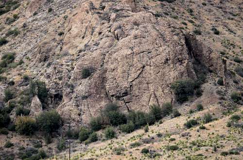
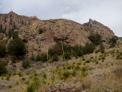
There are exceptions, though, and Basin Rock in the Chisos Mountains, close to the campground and the lodge, is one of them.
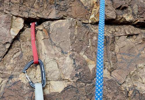
At Basin Rock, there are three established routes, some with variations. Difficulty ranges from 5.5 to 5.9. Although the routes have bolted anchors, do not come out here expecting to clip bolts, as these are trad routes. Do expect runouts and questionable rock quality.
Much to my surprise given the obscurity of the routes here, the anchors were in very good to excellent condition when I climbed here in March 2020.
Getting There
First, use photos on this page to spot the crag, and then plot an approach. We drove into the campground and then roughly followed the power lines, which pass close to the crag, until we picked up a trail, sometimes faint, leading almost to the base of Basin Rock. This involved a steep descent into and out of a wash, with a lot of desert brush to crash through or avoid.
A better way I found on a second visit is to hike down the service road that leaves the campground and depart from it for the wash when it bends west toward the Window There's even a faint trail leaving the wash; use it if you can spot it.
Expect the approach to take 30-45 minutes even though the distance is short.
Routes
There are three established routes. From left to right:
- Shattered Crack, 5.6-- Start on a low-angle slab (Class 4-5.2) and move into a left-facing corner system. There is a questionable Tricam or cam placement about 15’ up the slab and then nothing until the corner. A fall near the corner would mean decking, or at least a cheese-grater slide. From the corner to the anchors (two bolts with chains), there is good protection. From the anchors, you can also TR straight up the face; the grade is about the same.
- Javalina, 5.9-- This starts the same as Shattered Crack, but somewhere around halfway up, you pull out of the corner and onto the face to the right (the 5.9 move), and then you finish on easier ground to a three-bolt anchor, which is hangers only. We did not have time to climb this route, but what seemed like the easiest way to exit the corner was far easier than 5.9; lower, though, were a couple spots where it looked 5.9 or harder.
- Main Face, 5.5/5.6-- This goes up the broad face on the right side of the crag. Many variations are possible. I followed the pro as much as I could, which led to some mild runouts. The anchor is three bolts, each with a hanger, a quick link, and a very rusty chain link (on two of them). Instead of rapping or lowering from here on those rusty links, scramble about 50’ or so up Class 3/4 ground to the top of the formation. Just below the flat top, there are three bolts with hangers that one can use to belay someone who does not want to solo this “pitch.” After that, walk off and back down to the base.

|

|

|

|

|

|
You can rappel with a 70m rope. Make sure to knot the ends since there won't be much to spare. Instead of rappelling, though, just take the walkoff via the loose gully on the east side of the peak.
Red Tape, Camping and Lodging, and Links
The entry fee is currently $30 per vehicle and covers you for a week.
Camping is available at the Basin Campground. You can reserve sites at recreation.gov. Spring, fall, and holidays, the campground usually fills.
The Chisos Mountain Lodge is also an option. It, too, can be hard to reserve.
When to Climb
Fall through spring. Summer might be okay at this elevation but likely will still be very hot.