
|
|
Mountain/Rock |
|---|---|
|
|
32.39300°N / 106.577°W |
|
|
Dona Ana |
|
|
Hiking |
|
|
Spring, Summer, Fall, Winter |
|
|
7721 ft / 2353 m |
|
|
Overview
Baylor Peak is a very accessible, moderate peak at the North end of the Organ Mountains in Las Cruces, New Mexico. The Southern New Mexico climate keeps it in season year round, and the three mile approach makes it a perfect choice for a half day hike. The summit, like most in the area, rewards the hiker with spectacular view in all directions. To the West is Las Cruces, the Dona Ana Mountains and the Rio Grande. To the East are the shimmering dunes of White Sands National Monument and the Army's Missile Range. To the South are the big, craggy peaks of the Organ Mountains, and to the North the San Andres Mountains stretch to the horizon.The hike starts at 5,600 feet, reaches Baylor Pass at 6,880 feet, and tops out at 7,721 feet.

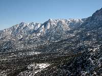
Baylor Peak from the summit of Organ Needle

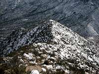
Baylor Peak from the East
Getting There
Baylor Peak can be approached from the Aguirre Springs recreation area on the East side, or the Baylor Pass trail head on the West. Either way, the hike is about 3.5 miles to the top (a bit shorter from the East).Getting to the Baylor Pass Trailhead: From Las Cruces, take I-70 East to NASA Road. Turn right on NASA Road and follow it a few miles to the well marked trailhead parking lot on the left. The road turns to dirt soon after you leave I-70, but it's very well maintained.
Getting to the Aguirre Springs Trailhead: From Las Cruces, take I-70 East, over the pass, to the Aguirre Springs turn off. It's about 1 miles after the pass, on the right. Follow the road for a few miles to the recreation area.
From either direction, follow the we trodden trail to Baylor Pass. For most people, this is the turnaround point, but Summitposters would not be satisfied with a simple "pass" - especially when there is a summit less than half a mile away.
From the pass, turn North and aim up. The trail quickly fades away but it's hard to lose your way. Pick your way gently through the shrubs, sotol and other pointy plants. Stay to the left of the broad ridge. The East side gets very steep and cliffy. Follow the ridge to the summit.

Red Tape
Parking at Aguirre Springs is $3 per vehicle. Parking at the West side trailhead is free. The actual trail and peak are on BLM land.Camping
There are 55 family camp sites and 2 group areas at Aguirre Springs. Drinking water and firewood is available at the host residence along the road to the campground. Phone 505-525-4300 to reserve group sites.On the West side Baylor Pass trail are a few primitive camp sights. These are about 2 miles up from the trailhead and consist of a few covered picnic tables and flat areas for tents. I've never seen anyone camping there - but they're free with no reservations required!