


-
 4484 Hits
-
 83.1% Score
-
 16 Votes
|
|
Area/Range |
|---|---|
|
|
45.72920°N / 7.57946°E |
|
|
Hiking |
|
|
Spring, Summer, Fall, Winter |
|
|
3340 ft / 1018 m |
|
|
Note
La montagna chiama i suoi figli, ed essi rispondono fedelmente al suo appello… Osvaldo Cardellina, Diario alpinistico, 1964-65 Page texts: @ OsvaldoCardellina "Osva", passed away on May 2, 2022. Page owners: Christian Cardellina e Osvaldo Cardellina. Any updates from September 12, 2022: Antonio Giani, page administrator, friend and climbing companion. Testi della pagina: @ OsvaldoCardellina "Osva", scomparso il 2 maggio 2022. Proprietari pagina: Christian Cardellina e Osvaldo Cardellina. Eventuali aggiornamenti dal 12 settembre 2022: Antonio Giani, amministratore della pagina, amico e compagno di salite. |
Garnets Overview Vesuvius
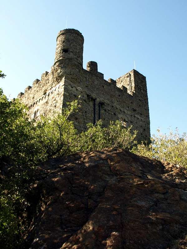
A valley unbusy, almost forgotten by Walkers. Not many who frequent it but among these we highlight the mineral researchers. This area is situated on the slopes of Mount Barbeston (2.482m) and just above the Ussel Fraction (608m) and the Bellecombe Village (1.018m) in the municipality of Châtillon, which is, however, placed beyond the course of Dora Baltea. The Saint Clair Bridge over the same allows you to connect these two areas constituting the access road to the hill on the opposite side, right at the foot, after the locality of Taxard, of Ussel Castle that from here looks bleak and threatening. From the bridge the road asphalt continues towards Southeast reaching the eponymous village and then continue again with this direction until you reach the dominating Bellecombe village, where at the small Church ends. Beyond merely continuing a farm road from which depart in different directions different paths. The first or path n° 1 "runs away" immediately to the East and crossed the tiny Monte Avi (1.124m) is directed towards the characteristic Village Walser of Rhodo (1.080m) in the valley adjoining now belongs to the Municipality of Emarese before that of Montjovet. The second or route n° 3 begins at about 1.100 meters in the opposite direction, or West-southwest, reaching, after crossing the Torrent Pessey, the Prenego Alps and Crête Chardon (1.452m) where flexing first in the South and then back to the West It comes to those Pragarin (1.528m), Salé Lower and Upper (1.742m) and finally Valmeriana (1.791m), just on the Northern slopes of Mount Barbeston and at the beginning of the road to the Colle or Hill of Valmeriana (2.281m) towards the way normal to the same. Finally, the last or the trail n° 2 continues concurrent with the dirt road by sending a first branch at the Alpe Mont Ros di Sotto (1.385m) to connect with the Alpe Pragarin and a second south towards the Biolasse Alps, Mont Ros Superior (1.609m), Toule (1.841m) and finally to Col Goddet or Valcrusa (2.110 meters around) between Mount Barbeston and Mount Lyan (2.178m). From this last start towards North-northeast the ridge from Mont Bec (2.088m) form the small rocky ridge called as the Banchettes which constitues the Eastern edge of this little valley. The opposite margin or Western instead is marked by the course of the two Torrents Pessey and Molinaz towards Châtillon Pontey Municipalities, in whose land stretches a rocky-wooded promontory that originates from the Alps underlying the Mont Barbeston and ending at the bottom first above Bellecombe Village and then descend to the Hamlet of Ussel. All this vast and ancient area is rich in minerals (mainly garnets and Vesuvius) for which a Regional Law since over two decades prohibits the collection and is the main reason of the progressive abandonment of this zone just outside the Natural Park Monte Avìc, but which also it is rightly protected.
![]()
Reddish garnets from the rocky walls of Bellecombe, by Camillo Roberto Ferronato

Vallone poco frequentato, quasi dimenticato dagli Escursionisti. Non sono in molti che frequentano Bellecombe. Tra questi si evidenziano i ricercatori di minerali. Quest'area é situata alle pendici del Monte Barbeston (2.482 m) nonché appena al di sopra della Frazione di Ussel (608 m) e del Villaggio di Bellecombe (1.018 m) nel Comune di Châtillon, il quale però é collocato al di là del corso della Dora Baltea. Il Ponte di Saint Clair sopra la medesima permette di collegare queste due zone costituendo la via di accesso alla collina della parte opposta, giusto ai piedi, dopo la località di Taxard, del Castello di Ussel che da qui appare tetro e minaccioso sulla Dora. Dal ponte la strada in asfalto prosegue verso Sudest raggiungendo la frazione omonima per poi proseguire ancora con questa direzione fino a raggiungere il soprastante Villaggio di Bellecombe, dove presso la piccola Chiesa termina in un piccolo parking. Oltre proseguono soltanto una strada poderale dalla quale partono in diverse direzioni vari sentieri. Il primo o sentiero n° 1 "fugge" subito verso Oriente ed oltrepassato il minuscolo Monte Avì (1.124 m) si indirizza verso il caratteristico Villaggio walser di Rhodo (1.080 m) nel vallone attiguo, ormai appartenente al Comune di Emarese prima di quello di Montjovet. Il secondo o sentiero n° 3 parte a quota 1.100 metri circa in direzione opposta ovvero Ovest-sudovest raggiungendo, dopo aver oltrepassato il Torrent Pessey, le Alpi di Prenego e Crête Chardon (1.452 m) dove flettendo dapprima a Mezzogiorno e poi nuovamente ad Occidente perviene a quelle di Pragarin (1.528 m), Salé Inferiore e Superiore (1.742 m) ed infine Valmeriana (1.791 m): questa é posta giusto alle pendici Settentrionali del Monte Barbeston nonché all'inizio della via per il Colle di Valmeriana (2.281 m) verso la via normale al medesimo. Infine l'ultimo o sentiero n° 2 prosegue dapprima concomitante alla strada poderale inviando una prima diramazione presso l'Alpe Mont Ros di Sotto (1.385 m) a collegarsi con l'Alpe Pragarin ed una seconda a Sud verso le Alpi di Biolasse, Mont Ros di Sopra (1.609 m), Toule (1.841 m) e da ultimo al Col Goddet o di Valcrusa (2.110 m), posito tra il Monte Barbeston ed il Monte Lyan (2.178 m). Da quest'ultimo parte verso Nord-nordest la cresta che dal Mont Bec (2.088 m) forma la crestina detta delle Banchettes costituente il margine Orientale di questa vallata. L'opposto od Occidentale invece viene segnato dal corso dei Torrents Pessey e Molinaz rispettivamente in discesa verso i Comuni di Châtillon e Pontey, in mezzo ai quali si allunga un'arrotondato promontorio roccioso-boschivo traente origine dalle alpi sossostanti al Mont Barbeston e che termina in basso dapprima al di sopra del Villaggio di Bellecombe e poi scende fino alla Frazione di Ussel. Tutta questa vasta ed antica area risulta ricca di minerali (soprattutto granati e vesuviane) per i quali una Legge Regionale ormai da oltre due decenni ne vieta la raccolta ed é questo il principale motivo del progressivo abbandono di questa zona appena al di fuori del Parco Naturale del Monte Avìc, ma che ugualmente viene giustamente attentamente controllata nonché protetta.
- From Torino, Milano, etc: Motorway A5. Exit Country of Châtillon. From Switzerland: through the Grand St. Bernard Tunnel or the homonym pass. Drive to Aosta, for Châtillon. From France: through Mont Blanc Tunnel or Petit St. Bernard Pass. It isn't necessary to enter in Motorway A5, you can drive through SS.26 Aosta direction. Exit Châtillon.
![]()
St. Clair Bridge on Baltea, by Osw 2016
BY PLANE:
- Aeroporto "Corrado Gex" Saint Christophe (Aosta).
Approach towards the vallon
 |
 |
 |
 |
 |
APPROACH: from Ussel/Bellecombe Fractions (North): from Pontey (523m) go up with asphalt road in the Hamlet of Ussel (608m; beautiful Castle built by Counts of Challants in 1350, not long since collapsed and renovated, well worth a visit) and continue with the same to the Village of Bellecombe the input of the same name vallon, up to this point is also, for the purists, can come with paths n° 1/3 respectively starting from Ussel and Pontey-Torin (466m). From Bellecombe (1.018m, famous for its mineral typical of Vesuvius and garnets) always proceed to the South by the private dirt farm road that reaches the alpine pastures of Mont Ros Desot (1.385m), crosses the Moriola Torrent and ends to Upper Mont Ros Pasture (1.429m), from where a unnumbered path towards the Alp Toule (1.841m), sited just at the feet of Col Goddet or Valcrusa (2.110m) and located between Mount Barbeston and Mount Lyan (2.178m).
VARIANT: a path n° 2 with a semicircular turn more to the West brings you to this 1.780 meters in altitude through the small villages of Biolasse Under and Over (1.609m). From Alpage climb to Southeast with a trace of an area of bushes and with a sudden progressively steeper, formed by a large casting blocks of greyish-white (furthest to the West not to be confused with the one that comes down from the Antetop West of Mont Lyan) and some small crushed rock in the terminal, reach the Goddet or Valcrusa Hill (about 2.105/10 meters) between Mount Lyan (2.178m) to the East and Barbeston (F/F+; 3h'30/3h'45 Bellecombe until Valmeriana Hill; 3h'15/3h'30 up to the Goddet Pass).
AVVICINAMENTO: dalle Frazioni di Ussel/Bellecombe (Nord): da Pontey (523 m) salire con la strada asfaltata alla Frazione di Ussel (608 m; bel Castello costruito dai Conti di Challant nel 1350, crollato e da non molto tempo ristrutturato, meritevole d'una visita) e proseguire con la medesima fino al Villaggio di Bellecombe all'ingresso dell'omonimo Vallone; fino a questo punto é inoltre, per i puristi, possibile giungere con i sentieri n° 1/3 che partono rispettivamente da Ussel e da Pontey-Torin (466 m). Da Bellecombe (1.018 m; famoso per i suoi minerali con vesuviane e granati) procedere sempre verso Sud tramite la strada poderale privata raggiungente gli Alpeggi di Mont Ros Desot (1385 m), attraversa il Torrente Moriola e termina al Mont Ros di Sopra (1.429 m) donde un sentiero non numerato raggiunge l'Alpe di Toule (1.841 m), collocata giusto alle pendici del Col Goddet o di Valcrusa (2.110 m), tra Barbeston e Monte Lyan (2.178 m).
 |
 |
 |
 |
 |
VARIANTE: un sentiero n°2 con giro semicircolare più ad Ovest si riunisce a questo a 1.780 metri circa passando per i Villaggetti di Biolasse di Sotto e di Sopra (1.609 m). Dall'alpe salire verso Sudest con una traccia tra una zona di cespugli e con un tratto progressivamente più ripido, formato da una grande colata di blocchi bianco-grigiatri (quella più verso Ovest da non confondere con quella che scende dalla Antecima Ovest del Mont Lyan) e qualche piccola roccia frantumata nel tratto terminale, raggiungere il Col Goddet o di Valcrusa (2.105/10 circa) tra Monte Lyan (2.178 m) ad Est e Barbeston (F/F+3h'30/3h'45 da Bellecombe al Colle di Valmeriana; 3h'15/3h'30 al Col Goddet o Valcrusa).
 |
 |
 |
 |
 |
Important Information
- REGIONE AUTONOMA VALLE D'AOSTA the official site.
- FONDAZIONE MONTAGNA SICURA Villa Cameron, località Villard de la Palud n° 1 Courmayeur (AO) Tel: 39 0165 897602 - Fax: 39 0165 897647.
- A.I.NE.VA. (Associazione Interregionale Neve e Valanghe).
Useful numbers
- Protezione Civile Valdostana località Aeroporto n° 7/A Saint Christophe (Ao) Tel. 0165-238222.
- Bollettino Meteo (weather info) Tel. 0165-44113.
- Unità Operativa di Soccorso Sanitario Tel. 118.