Day 1
Since my brother moved to Sun Valley I have made a late summer pilgrimage to visit and to hike and backpack this terrific area. This was my fourth trip. This time Kim accompanied me and we drove. I flew in on the three earlier visits. It's a long day of driving but not so bad with two people trading off. We headed out at 6:30 am on Saturday and arrived 680 miles later and one time zone change at 6:45 pm MDT in Sun Valley. My house is at 220' above sea level and my brother's is at 5800'. The Sawtooth and White Cloud Mountains soar much higher. We spent Sunday just getting a little acclimatized.
Since Kim had never hiked in Idaho I planned another grand tour of the Sawtooths. Turns out a fire broke out the day before and half the route was closed and being evacuated. Time for a change of plans. A quick scan of reports on the Internet led to a backup idea. It required an extra 60 miles driving each way but looked really good. We set out early on Monday morning heading north over Galena Summit and into the Salmon River Valley.
We stopped at the Stanley Ranger Station for last-minute fire info and discovered the Sawtooth fire was out and the route was open. After a quick huddle we chose to use our back up plan in the White Cloud Mountains. We drove east still on Highway 75 along the growing Salmon River. We stopped where smoke seemed to be coming from the hillside along the road. In fact, it was steam from Sunbean hot springs. The water was very hot. A family was down in a pool along the Salmon River where the hot water flowed.
Back on route we reached the East Fork Salmon River Road and turned south. My old hiking book talked about 5 miles of pavement. Not any more. It is now paved for 15 miles with farms up the valley. Very craggy terrain with sagebrush and views to the peaks above. One mile of dirt led to a turnoff and 4 1/2 more miles of dirt to the trailhead near Livingston Mill. This is one of the more popular trailheads in the White Clouds and even on a Monday morning there were 4 or 5 cars there. The trail starts at 7200' which is higher than most of the crest of the Cascade Mountains in Washington.
![Trailhead Sign]() Trail Sign
Trail Sign![Livingston Mill]() Livingston Mill
Livingston MillIt was already warming at 9:30 am and we were soon in shorts and short sleeves. The trail soon crosses a creek on a single log. Every crossing was bridged and nearly every one had two side by side logs. The first two miles are open to motorcycles. At that point the trail splits. Left goes up to Frog Lake and the Boulder Chain Lakes. Right immediately crosses the creek and heads up to Walker, Island, and Big Boulder Lakes.
The route is never very steep. It climbs through forest and open fields of sagebrush dotted with flowers. We were a little surprised to see a lot of flowers in late August. We were passed by one group of day hikers heading up. A little later we met another couple coming down who backpacked to Walker Lake and the upper lakes. My books talked about crossing Quicksand Meadow. We reached a sign for a descent to the meadow but the main trail now continues on a traverse above the meadow and creek. This trail looked to be very new.
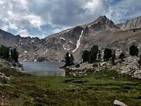
With the elevation and heat we were wilting on the trail. A little cool breeze really helped. Where the new and old trails met the route was again near the creek in a more sub alpine area. Big granite rocks dotted the ground with grass and smaller trees. we soon reached the intersection. Straight ahead a mile to Island Lake or right to Walker. After a break we headed on to Walker. The trail is steeper and rockier here but soon we were cresting a ridge and entering the basin. We wandered quite a way through meadows and along the outlet stream before reaching the lake.
Walker Lake sits at the end of a forested basin at 9239'. We were almost as high as Mt. Stuart in the Cascades but still in forest. Quite a change from what we are used to. The earlier backpacking couple we met suggested the campsite at the far end of the lake. We were about out of gas as we hiked past several nice sites along the lake. We chose a big site near the inlet stream. A little later another group came in and continued past the inlet to a nice site across the lake from us. We set up the tent, hung our food, had dinner, and were ready to call it a day. For the day we hiked about 8 miles with 2200' of gain.
![Reflection In Lake]() Evening Lake Reflection
Evening Lake ReflectionDay 2
This was the day we were looking forward to. After a day getting up to Walker we would now head up to the lakes of the upper basin. The info we had told of a boot path than followed the inlet up to a meadow than turned left to climb to a saddle gateway to the upper basin. We found cairns near our campsite and followed them up to the right of the creek. The path was pretty easy to follow to the large meadow. Lots of flowers especially in the meadow. At a final cairn the route split. right headed up to Sheep and Slide Lakes and left quickly disappeared. We saw the rock wall above Walker Lake and a ridge heading down towards the meadow. We headed cross country in that direction.
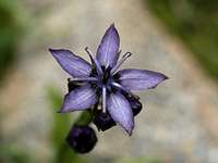
![Purple Flower]() Purple Flower
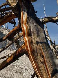
Purple Flower![Snag Art]() Snag Art
Snag ArtThere were far more flowers in the meadow area than we expected. Lots of purple aster everywhere on the whole route and especially here. We saw paintbrush, gentian, and many more as well. At times we found and lost the boot path but route finding was not difficult. At the base of the route up to the saddle the trail became very distinct. The route is most all on rock and some of it is loose. Still it is not a difficult scramble. In short order we crested the ridge just above the saddle.
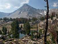
![Point 11,272]() Point 11272
Point 11272Wow! What a view from there. Hook Lake is just below and the blazing white David O Lee Peak is right above it. An outstanding view. The pass is at 9900' and the view in all directions is terrific. We headed down to the lake and rounded it on the left side. Beyond the lake is a plateau of granite, grass, and some trees. Stunning beauty. Similar to the Enchantments of the Washington Cascades but 3,000' higher. We crossed the plateau and saw big Sapphire Lake just below us. We dropped down to the lake where we met two of the four members of the other group in the area.
![David O Lee & Hook Lake]() David O Lee Over Hook Lake
David O Lee Over Hook Lake![Fishing Sapphire Lake]() Fishing
FishingThe mom had come up with her dad when she was 9 years old. Now 40 years later she was returning with her son. They brought fishing rods to the upper lakes. We decided to start at the top and headed around Sapphire (9888') and on up to Cirque Lake (10,060'). Aiming for a low saddle brought us right up to Cirque. The lake has steep walls on the back side and only rock and a little grass at the front. From Cirque we could look down to Sapphire and Cove laid out below.
A nice gentle ramp with some grass leads up from Cirque towards the Kettles. The Kettles are small ponds high in the rocky moraine that are frozen most of the year. They were our next goal. The moraine is a huge pile of boulders and scree. I headed across the boulders looking for the Kettles. I found one Kettle and it was not very impressive. More like a small tarn in a pile of rocks. Another one had a little water but was mostly still just a pile of snow.
I headed back to find Kim and she was engrossed in the rocks. Seems they all look like petrified wood. More like a whole petrified forest at 10,300'. Neat rocks at the very least. Right above us was the white slope of David O Lee Peak. The white color is unlike anything I have ever seen in the mountains. Distinctive and very beautiful. Although we were over 10,000' very little snow survives this late in the summer. We then headed back down the arm to Cirque Lake.
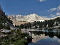
![Sapphire From Cirque]() Sapphire Lake
Sapphire Lake![Search Finds One Kettle]() One Kettle
One KettleFrom Cirque we took a more direct route back to Sapphire Lake. It took us over to the creek between Cirque and Sapphire. Well not all the way between. Cirque has no direct outlet. The creek pops out of the rocky hillside between the lakes. More flowers here including a very strange one. Photos will be below. We rounded Sapphire and headed towards Cove Lake some 46' lower. At the Sapphire outlet we decided to cross and ascend a narrow ridge to more lakes. We hiked up grass and boulders then some slabs to the ridge top. Near the high point we stopped. For the past hour we had seen smoke heading our way. Now it was here in a big way. The sky was brown instead of blue land Kim was having some breathing problems. Not serious but the smoke was getting thicker by the minute.
We chose to head back down. We had seen plenty of big high elevation lakes this day. Back at Sapphire we did choose to drop down to have a look at Cove Lake. A little cross country and we rose back to Hook Lake and soon the saddle to exit the upper basin. The boot path down was a little tougher with the loose rock at first but we were soon back at the meadow. Again we lost the trail but reached the trail split at the end of the meadow and followed the route right back to camp.
It was a terrific day of high country roaming. The lakes were gorgeous and the granite was spellbinding. Add in the numerous 11,000' peaks all around and it was a day to remember. The smoke began to dissipate in the evening and was mostly gone in the morning.
Day 3
We awoke to very little smoke. We brought enough food for four days but decided three was enough. We packed up and headed back down. One more day trip to a new area sounded better than another day in the basin. With lighter packs and almost all down hill ahead we left Walker Lake. As always the trail down seemed much longer than up. It was another warm day but our early start helped with the heat. We were able to take some more time to enjoy the views out along the trail. The different colored rock is really amazing.
The last two miles we met a number of groups heading up. I was surprised to see half a dozen groups going in on a Wednesday morning. Several groups were headed towards the Boulder Chain Lakes. One group had hiking gear but chose to do the lower trail on motorcycles. One gentleman even had on a University of Washington shirt on. I mentioned Huskies and he thought I was talking about his Lab dog.
It was downright hot when we saw Livingston Mill and slogged the last half mile through sagebrush. There were now 11 cars in the lot. Our timing was impeccable. We had only the one group in the basin for our stay. On the drive back to Highway 75 we had a group of bighorn sheep run across the road in front of us. I rolled down the window and Kim took a photo while they posed. Other than squirrels they were the only animals we saw.
We drove back to Stanley and started looking for a campground. Redfish Lake has many but they were mobbed with RVs and kids running all around. Great for many but we wanted a little more peace and quiet. The Sunny Gulch CG provided both. We were far from the highway and behind the site was a short trail down to the Salmon River. Very nice. We went back into Stanley for a real dinner after a few nights of dehydrated and it was a real improvement.
We packed up for a day hike. In the morning we were off to see the western side of the White Clouds.
All my photos can be found at: Big Boulder Lake Photos.


Comments
Post a Comment