
|
|
Mountain/Rock |
|---|---|
|
|
33.92370°N / 111.979°W |
|
|
Maricopa |
|
|
Spring, Fall, Winter |
|
|
4698 ft / 1432 m |
|
|
Overview
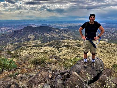
Black Mesa is the crown jewel of the Spur Cross Ranch Conservation Area north of Cave Creek, Arizona. Standing at 4,698’, it is the highest point in the area, with a prominence of 878’.
There are trails that lead to the summit, albeit hard to follow in some places higher up. If well planned, reaching the summit isn’t too difficult. Budget 5 ½ to 7 hours to get up and down.
Spur Cross is relatively lush compared to the rest of the Phoenix valley. Located just north of Cave Creek which sits at the top of the Phoenix metro area, it feels isolated enough, because it is a preserve and not just mountains surrounded by residential areas. Black Mesa isn’t the most popular summit in the area. That would probably be Elephant Mountain, but it is quite a worthwhile destination.
The best time to hike Black Mesa is in between November and March. Because it is a long hike and with lots of rocks and high grass, there is danger in running into rattlesnakes any other time of year. It can also get pretty hot during the summer months.
Getting There
Cave Creek is accessed from Cave Creek Road via the Carefree Highway off the I-17 or via the Cave Creek Road exit off of the 101. Once in town, turn onto N. Spur Cross Road which reaches the parking area in 4 ½ miles from town.
Route
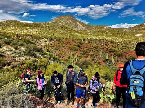
Walk down to the trailhead and take a left to start out on the Spur Cross Trail, and then eventually turn right onto the Tortuga Trail and follow it until reaching a sign to the Elephant Mountain (EM) Trail. From the junction it is about ¾ of mile to the junction between the Elephant Mountain Trail and the Tortuga TM 252 Trail. It is pretty straightforward to follow the EM trail, which heads directly towards the massive rock formation making up the Indian Fortress summit.
Once at the junction, Indian Fortress and Elephant Mountain are to the left, and Black Mesa is to the right. Take a right on the TM-252 trail and continue for only about 100 yards until reaching a water tank. Just before the water tank, there’s a use trail on the left. Take this trail and follow it along a small ridge as it gradually ascends and levels off to a plateau hugging the north side of Elephant Mountain. The trail then descends to a wash and continues up the slope towards Black Mesa. The trail gets harder to follow the further up towards Black Mesa. However, a generous number of cairns make it easy to follow towards the base of Black Mesa.
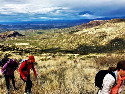
At about 4,000’ and 4 ½ miles into the hike, the cairns are less plentiful. At this point, you need to take a left and continue a gradual hike towards the northwest side of Black Mesa. Eventually, a steep path leads to the top of the mesa. The trail isn’t completely clear, but cairns are there to help. Once on the top of the mesa, head south. The trail disappears for the most part and cairns aren’t always clear, but as long as you stay straight on the western edge of the mesa top, you’ll find the summit rocks and marker.
It is about 6 miles each way from the parking lot, gaining nearly 2,800’ on the way up, and over 3,200’ round trip.
Red Tape
Entrance to the park is $3/ hiker. On weekends volunteers are often stationed at the park entrance to collect fees. Otherwise, grab an envelope and put in the $3 dollars and carry a permit on your person during the hike, or put it on your car. Spur Cross Ranch is open from sunrise to sunset. There is no water at the trailhead, but there are portable bathrooms.
Spur Cross Ranch Conservation Area
Hike Arizona page for Black Mesa