
|
|
Mountain/Rock |
|---|---|
|
|
39.58263°N / 119.67553°W |
|
|
Washoe |
|
|
Hiking, Scrambling |
|
|
Spring, Fall, Winter |
|
|
5376 ft / 1639 m |
|
|
Overview
Rising to the east above the city of Sparks, Nevada, The Canoe Hills make up a series of foothills in the Pah Rah Range. There are three distinct summits, the highest a rocky-topped, pyramid-shaped hilltop that reaches an elevation of 5,376 feet. The second summit is a rocky-topped mesa-shaped hilltop about 700 yards to the south, that reaches an elevation of 5,306 feet. The third is about 1,000 yards East-Southeast that reaches an elevation of 5,356 feet. These are not prominent peaks, but given their shape, they do stand out.The area is visited frequently, and dirt roads leading to the base of each summit block. There are two starting points: One from a residential area and the other from Golden Eagle Regional Park.
Views from these summits are very nice. One can see the Northern Sierra Nevada range to the west, the Virginia Range to the south, Tule Peak 8,723’ to the north, Peavine Peak 8,266’ directly west and Spanish Springs Peak 7,401’ directly to the east.
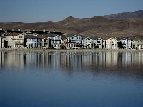
Canoe Hills from Sparks Marina.
The Canoe Hills are best hiked in wintertime. Bugs are prevalent during other times of the year. Rattlesnakes may be present on the rocky areas during warm weather months and the mud can be a problem during spring time.
Getting There
The closest trailhead is located in northeast Sparks and is easily accessible. From Reno take I-80 east to exit 21 (Vista Blvd). Take Vista north for about 2.7 miles and merge east onto Los Altos Blvd. Follow it for about 1 mile and turn right at a round about up Belmar. Follow it up hill to the end. It ends at Earthstone Drive. There is a dirt road heading towards the hills. Park anywhere on the street.To reach Golden Eagle Regional Park, do not turn onto Los Altos Blvd. Instead, continue on Vista for just over 5 miles and follow signs into the park. Onceyou enter the park, stay right and continue for almost a mile. There is a trailhead on a dirt road on theright. That is the starting point.
Routes
From Earthstone, starting from the end of the pavement, there is a dirt road heading up to the hills directly towards the pyramid-shaped highest summit. The road continues past a water tank on the right. Shortly after the water tank the road splits. You can take either the road to the right of pyramid-shaped peak or to the left of it. I recommend taking the road to the right. It takes you 100 feet below the summit, and allows for a fun, but easy, rock scramble to the top.The second eastern summit is reached by taking the road at the base of the pyramid and head southeast for about 2/3rds of a mile.
The south summit is reached by cutting off the road and heading south, and then scrambling 50 feet up to its mesa-shaped summit block.
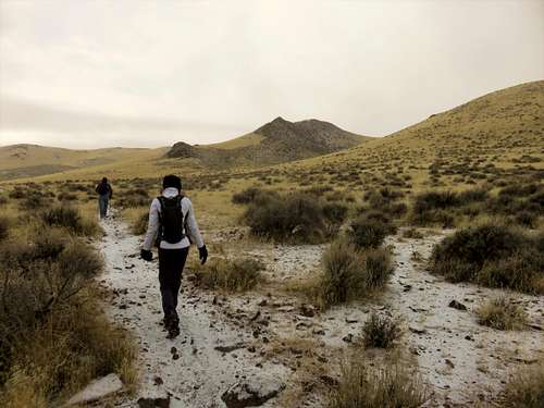
Looking at the higher summit (Peak 5376) while climbing up the lower summit (Point 5306)
It takes a little under a mile and 490 feet of elevation gain to reach the highest summit, and to hike all three summits requires about 4 miles of hiking.
From Golden Eagle Regional Park, there are a few ways to explore the Canoe Hills. To reach the highest point, head up the main road for about 1/2 mile, and then a trail heads straight uphill. After 1/4 mile, another road heads steeply up towards the pyramid. You can scramble up to the summit in about 1/4 mile and then explore other summits.
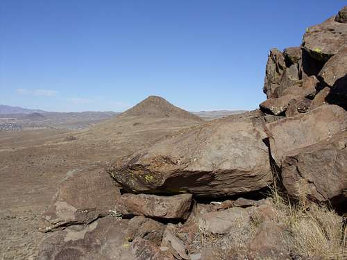
The Canoe Hill Pyramid seen from Golden Eagle Regional Park
However, perhaps the best way to explore all three summits is to continue up the trail all the way to the top of the switchbacks. There is a bench. This is about 2.1 miles from the trailhead. At this point, you are just below the Canoe Hills east summit - Point 5,356'. From here, you can then hit the other two summits and then go back to the to the bench and head back down. That is about 6 miles total, gaining about 1,050' total.
Red Tape
Although the summits are on public lands, there is some private land at the base. There is a sign at the start of the dirt road that says "Private Land, No dumping". However, at a recent visit on Halloween day 2015, residents assured me that only referred to the immediate area behind the sign. The dirt road is a BLM access road used by the residents to hike and shoot and enjoy the desert. Construction has boomed in this area, but it is not anticipated that this would result in blocking access to the hills, which have a series of trails and are hiked quite frequently.There are no restrictions in Golden Eagle Regional Park.
shaggyp - Aug 4, 2013 2:06 pm - Hasn't voted
Unofficial NameWhile it is true that there is no formally posted name for these hills, the locals have called it Canoe Hill for at least the last 40 years (on account of it looking like a canoe). I have confirmed this with multiple non-connected individuals ranging in age from late 40s to early 70s and the map on my iphone even recognizes it under the name.
hgrapid - Aug 4, 2013 2:47 pm - Hasn't voted
Re: Unofficial NameThanks. Is that for the general hills, or just the highest hill?
shaggyp - Apr 1, 2014 1:21 pm - Hasn't voted
Re: Unofficial NameSorry, haven't checked in for quite a while. As I understand it, it was for the pair of points. From a distance it looks like a canoe.