This hike is billed as steep and brushy, and it did not disappoint. We've tried this hike once before without knowing how much brush there was. I generally wear shorts so I paid dearly that time, but for this trip I made sure everyone learned from my mistake, and so I don't think the brush annoyed us as much.
10 people showed up for this trek (where were thou, Taco?) + 1 dog, Ajala. Not sure what Ajala thought of the brush, but most likely not positive thoughts.
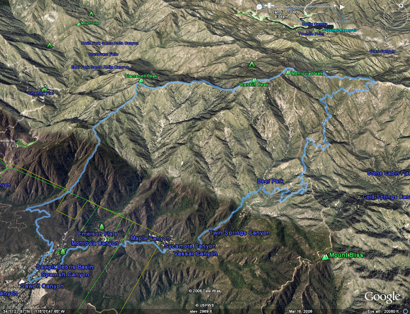
This hike starts innocently enough by taking the Lower Clamshell Truck fire road for about a mile, and then taking a sharp right and gaining a ridge heading northeast. Previous reports (including mine) note that a man used to live in a blue tarp here, but we did not see the blue tarp this time.
Anyways, this ridge sort of peters out and intersects the Bill Cull trail after 1/2 mile. At this point there are a few small branches of the main ridge heading north; you should take the east one. I attempted to ascend the western portion which was ridiculously steep (the same one I used last time). As others found the other ridge to be easier, Ofir and I decided to be stubborn and try to ascend ours.
Well a little additional energy was lost, but no worries from here on. Now we just had to keep going up over the steep, varied, and brushy terrain.
The next mile ascends 1400 ft, and from the fireroad up to Clamshell Peak the path ascends 2800 ft in 2.5 miles.
After Clamshell, we descended to a fireroad (Upper Clamshell) and followed it for about a 1 1/2 miles. Then we veered off to the right to begin the steep asscent to Rankin Peak. This was longer than I remembered last time! 600 ft in 1/2 mile. Then we went over a bump and then reached Monrovia Peak.
This was the worst case of my gpsmap 60csx over estimating the elevation gain, by over 2000 ft! I am assuming the barometric pressure was fluctuating more due to the weather. This is a case where doing my own smoothing allowed me to get a much better estimate of the elevationg gain.
Most seemed pleased with the hike. It had its tough sections (especially up Roundtop) but not extreme overall. If one takes the ridge up Iron as opposed to the fireroad, that would change.
Parents refers to a larger category under which an object falls. For example, theAconcagua mountain page has the 'Aconcagua Group' and the 'Seven Summits' asparents and is a parent itself to many routes, photos, and Trip Reports.