Well Worth the Effort
A short detour while on a business trip landed me in Cape Town, South Africa. A beautiful country and an incredibly beautiful city, it's most prominent feature is Table Mountain, one of the seven natural wonders of the world. Towering above the city at 3,558 feet, the mountain was first climbed in 1506 by Antonio de Saldanha. You see the mountain flying into the city, sailing into the city, from nearly anywhere in the city. I wanted to get up to the top, I just needed to make the time and figure out how.
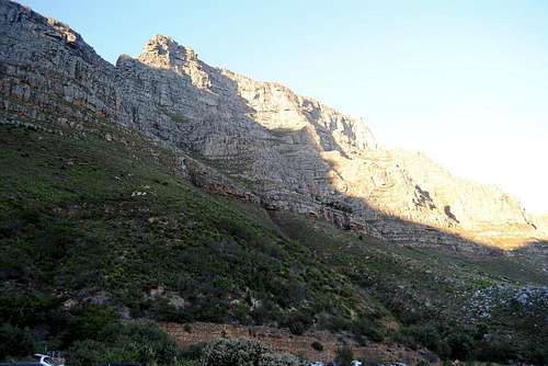
![Table Mountain from the bottom of Platteklip Gorge]()
There are a number of ways to get to the top of Table Mountain. The most popular (and done by thousands every year) is the cable car that runs from the lower cable station on TafelbergRoad up to the "top" (it runs to the top of the mountain, but not the summit. More on that later). To make the trek this way, all one has to do is drive up, park along the road, buy the ticket and wait for the car to take you up. You can then hike around the top of the mountain (which is relatively flat, though can get tricky at some points), or just hang out near the upper cable station, take pictures at the lookouts, go to the gift shop and restaurant, and then head back down. All in all, one could be up and down in about 20 minutes (including 2 minutes for some breathtaking pictures from the top).
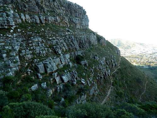
The alternative to the cable car was to hike/climb to the top. There are many different trails and routes up both the front and back side of the mountain. Some are easier than others, some more gradual than others. The most popular, though, is Platteklip Gorge. Platteklip is quite literally a gorge that runs up roughly the middle of the mountain- it's the most direct route up...but not the easiest. It's the fastest route up (due to it's overall short distance), but still not the easiest. The gorge is roughly 2.5 to 3 kilometers, and climbs about 3,400 of the 3,558 feet. Run that math real quick- 2.5 kilometers to cover an elevation gain of 3,200 feet. Yeah, it was steep. About 80% of it was like climbing wide and large "stairs" (not literally) up the side of the mountain. Use of the hands was pretty ideal only about 15% of the time, but you essentially feel like a lilliputian climbing huge stone stairs up this mountain. Because of this, the exposure element is relatively high. Loss of balance climbing stairs (especially as you get tired) is pretty easy to experience, and in this case a fall backwards would send you literally tumbling down the face.
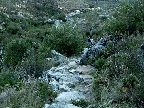
![Heading up Table Mountain s Platteklip Gorge]()
With all that in mind, my colleague wanted to take the cable car up. But I didn't want to miss this opportunity...so I convinced him to hike/climb it with me. He agreed, and we made plans to set out early Sunday morning to do it.
Because of a time crunch, we decided that we'd ascend via the gorge, but that we would take the cable car down. As much as I wish we didn't do it this way, it was important that we were off the mountain by mid-day, so this was the only option. We made it up Tafelberg road, and passed the lower cable station. About 4.5 kilometers later (this becomes important later) down the road, we found the parking area for the gorge. We parked, gathered our gear, stretched a bit, and set out.
This particular path up is popular with tourists and locals alike, so we expected to run into others folks on the way, despite our early start time of 0630. We came across locals, groups of tourists, a small youth group, people with their dogs, people with their parents, etc. About 20 minutes in, everyone is tired and struggling for breath. The trail and path is small most of the way up, so we (as well as everyone else) would climb for a bit, then stop and take a break to drink, take pictures, and catch our breath. People would then leapfrog us. It would continue this way for 80% of the route.
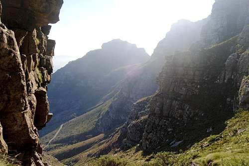
Starting early had a serious advantage: you started in the shade. This kept us and the temperature low enough to make it tolerable. But at about the half way point, the peaks to our left (Devils Peak) gave way to the sun. All the sudden, what was a challenging climb became a seriously challenging one. The trail got harder and easier on and of as you went, but the effect of having the sun beating down on the back of your neck completely changes the experience.
![The sun coming round the gorge]()
![Looking down the gorge]()
About about the 80% point, we noticed that we were no longer being leap frogged when we stopped. We weren't stopping less...in fact, we were probably stopping more because of the heat and our exhaustion. But the groups we had leap frogged with were gone. Using binoculars to look down the mountain, we saw many of them laid out along the trail, some going down, others just gone (had gotten off the trail and left). Many of the guide books and websites warn that despite it's popularity, the train isn't easy, and people get hurt and killed on it every year. Despite reading all of this, I even had the impression that it would be a bit "easier." Some folks (i.e. myself) seem to have under estimated the mountain or their ability. Luckily, at this height and skill level, such an underestimation can easily mean driving home, vice serious injuries or death.
At about the 90% point, the sides of the gorge are towered over by the sides of the mountain. So while you're still climbing in sun, your left and right is towering walls of rock, all you can do is go straight (and up) towards what looks to be the end. So onward we pushed.
![Half Way up]()
At the one hour fifty minute mark, we cleared the walls of the gorge and emerged on the top of the mountain. The path was rated for 2.5 hours, so we were under par for the time required, which was good (though mostly irrelevant). Once at the top, we had a decision to make. Depending on the time and our level of energy, the actual summit was to the east of the gorge opening. It was mostly a hike over, about 4 kilometers. Alternatively, 3 kilometers to the west was the upper cable car station that would take us down. We made it this far, not going for the summit beacon would have been dumb...so... we set off for it.
Evidently this is a rare decision for those who ascend the way we did. On the path to the beacon, we met not a soul. At this point we were walking along the top of the flat mountain, so the views in every direction were spectacular. It was quiet, with a slight wind that served to cool us down and allow us to forget about the sun for a while.
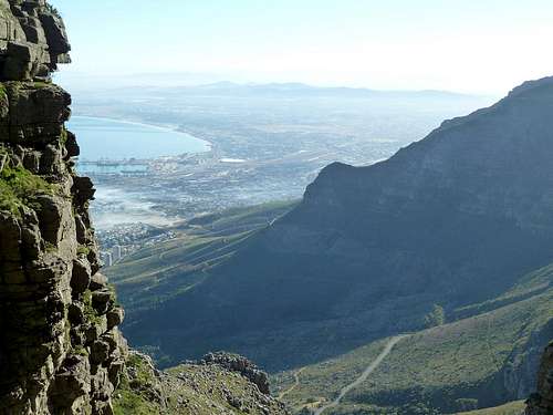
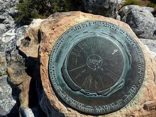
After about 40 minutes, we made it to the summit beacon at 3,558 feet. The view here of Cape Town below us, and the Cape of Good Hope and Cape Point in the other direction was a beautiful sight to behold. We took a fair number of pictures up here, and enjoyed the moment. A few other folks were around sitting and eating. We enjoyed a short snack before making our way back the same way we came.
![Summit Beacon on Table Mountain]()
But it wasn't till we were on the cable car that we realized our car wouldn't be at the lower cable station. In fact it was 4 kilometers away, parked near the gorge entrance. This was about the last thing I wanted to do now: hike another 4 kilometers on a hilly and winding road (Tafelberg) to our car. But alas, we had no choice. We made the walk, and eventually made it back to our vehicle. When all was said and done, we were back to our hotel (and badly in need of a shower) by 1230.
The alternative to climbing that day was Shark Diving. It was a tough choice at first, but we quickly decided Table Mountain was the way to go. It was a thrilling experience to climb such a landmark, in a foreign country. It was certainly the hardest climb I've had yet (though I expect that title not to last long).


Comments
Post a Comment