> Creta di Timau, 2217 m, > Cima Gaier, 1887 m, > Gamspitz, 1847 m, > Cima Avostanis, 2193 m.
Creta di Timau presented
Creta di Timau is the first peak east of Ploecken Pass / Passo di Monte Croce, which exceeds the altitude of 2000 meters. It is a nice, broad rocky complex, rising in its own short ridge just south of the main Carnic Alps ridge. The summit is sometimes also called Pizzo di Timau and its German name is Hocheck (in the local timavese dialect Hòacheika). Otherwise the word Timau originates in the pre-latin, celtic word *tim, which means water (referring to the nearby Fontanon water source).
The southern slopes of Creta di Timau are very high. They are falling all the way down to the small town of Timau, which lies on the altitude of only 820 meters. This side is rocky and wild, so no normal ascent goes directly over it. The northern side has a lower wall, which is on its western end very steep. So, also here no normal ascent goes up. And the same holds for the western ridge, which is sharp, consisting of several towers, and finally ending on the SW with the sharp Cima Gaier, 1887 m, and the even more impressive Gamsspitz, 1847 m - an attractive-looking tower which hosts some nice climbing routes. The weakest point of Creta di Timau is its eastern ridge, along which an easy normal approach goes.
As over these mountains in World War I the frontline went, still today all routes are using ex military paths. A decent 'mulatiera' ascends to just some 20 meters below the summit. East of Creta di Timau there's in a deep basin the nice Lago Avostanis. Next to the lake there's a mountain shelter (Ricovero Casera Pramosio Alta, 1940 m), and lower, along the mountain road, which reaches it, there's also the official mountain hut (Rifugio Casera Promosio, 1521 m), which can be reached by car from Timau. It's understandable that this side of the mountain is very much visited by Italian tourists and climbers.
Here also a ski tour can be done (PD+, S4), the upper part is very steep and the last meters are done without skis.
Interestingly, from the Austrian side no marked path ascends the main ridge close to Creta di Timau. Oh yes, on maps (for example Tabacco) non-marked paths are drawn there, but they are very hard to follow, because nobody seems to use them (except animals with their non-mountaineering logic). There, I had quite some troubles to get down from the mountain in three hours and also on the ascent from that side I was constantly losing trails.
West wall
From Paluzza (S)
From the North
Summit Panorama
The view towards East
The view from Creta di Timau is mostly opened on all sides. Higher mountains are towards the West, where the beautiful Hohe Warte / Monte Coglians group is rising. Polinik on the North is also a little higher, but it doesn't obscure much the view on Hohe Tauern range. From the SW to the NE the view on Carnic Alps and Julian Alps is completely free, sharp peaks are boiling all around. Quite picturesque is the nearby surroundings around Lago Avostanis. And towards the South, along the deep valley of But, your view flies down towards the low hills above Po river plane.
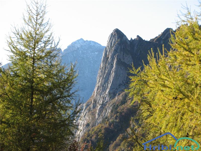
Gamspitz (also written Gamsspitz), 1847 m
Gamspitz from Timau
Gamspitz (left) and Cima Gaier (right) from Timau
Looking on a map nobody would think this small side bump is something special. But when you are driving down the road from Ploecken Pass / Passo di Monte Croce it's an eye catcher. When approaching Timau, suddenly a sharp peak with a wild south-oriented vertical wall appears in front of you. You stop your car, admiring it and asking 'What's that', usually the view from the SW catches both Gamspitz and the summit of Creta di Timau left of it. In Timau you stop again, let's say by the cathedral, and again above the old stone architecture the vertical 900 meters high south wall of Gamspitz is rising.
Gamsspitz (credit: Hribi.net: triglavski)
It can be ascended by a marked path (No. 402 and No. 452, from Hunters chapel towards the left) from Timau (3 h, weak ex military trail, sections of easy climbing UIAA I). If anyone has a personal experience, please share it with us! It's a steep, weak trail over grassy and rocky slopes with a very steep summit section (Italian grade EEA). Just north of Gamspitz there is Cima Gaier, 1887 m. I can be also ascended from the normal route to Gamspitz. We leave that trail in Prato dei Camosci, the broad, grassy valley, on 1620 m, continue steeply up to the notch 1840 m, and by the ridge up on the summit.
Otherwise Gamspitz is known by a nice south wall climb. It is graded UIAA III+/IV+, but only the upper part is that hard. The route can be exited on two places, if it proves to be too hard for you. The route was first climbed by Oscar Soravito in 1934. In 1984 the Ravascletto Alpine club installed fixed bolts. If there were also cables, it would be a hard ferrata, but as there are none, it stays a hard alpine climb. The route is dedicated to Antonio Grasselli. Some climbers are deterred from the upper part, because it's very covered with steep grass.
Below Gamspitz there's the karst source of Fontanon and a few nearby caves (deepened in the past by mining), which are worth visiting. The source was known and praised already in the times of Ancient Romans and can be reached by the marked path (No. 402). The visit is arranged as one of the geopoints of Carnia. The source lies at the base of an impressive Devonian limestone rock wall, originating from the Hercynian mountain range, which layers were accumulated in warms seas more than 360 million years ago. The sources are today partly exploited for provision of water and partly for a small electricity plant. The rest of the creek is flowing down the Würmian glacial morraine deposits into the But river.
Blaustein (Promos) / Cima Avostanis, 2193 m
Lago Avostanis
Blaustein / Cima Avostanis
East of Creta di Timau, there's Lago Avostanis and the hut - Ricovero Casera Pramosio Alta, 1940 m. The place is really beautiful. The clear mountain lake lies in a deep basin, formed originally by a tectonic fault and in the last glacial ages (Würm era, 18.000-15.000 years ago) modelled by glaciation. Above it, a more than 100 meters high and 500 meters wide vertical wall of Devonian limestone is rising. And below the wall a nice series of debris cones can be observed - made of rocks fallen from the wall due to frost and thaw. This wall is a popular climbing place with a series of routes between UIAA IV and VIIIa. The lake and the pastures beyond are however lying on the base of darker Carboniferous rocks, named Hochwipfel formation.
Above this wall, the grassy dome of Cima Avostanis / Promos / Blaustein is rising. It can be reached over the southern slopes from the marked path No. 402. Also Lago Avostanis with its wall is one of the Carnia geo sites - points along the geo trail.
Blaustein / Cima Avostanis is separated from Creta di Timau with the notch, called Sella Avostanis, 2080 m.
Geological Overview
As many other summits of the eastern part of Carnic Alps main crest, also Creta di Timau is made of Devonian limestone, some 400 million years old. Devonian was a long time period, so not all the rocks are the same, but the summit part of our mountain is mostly built of massive reef limestones, on some places mixed with mudstones, packstones and similar. That's the area shown in green and yellow.
Only small areas on the NE side of Creta di Timau are made of Carboniferous sandstones and grey shales, of the so called Hochwipfel formation (orange), some 330 million years old. They are forming more gentle landscape.
All the rest is for a visitor of Creta di Timau unimportant. White areas (dotted) on the map are more recent debris and moraine.
Getting There
Creta di Timau / Hocheck from Paluzza
For general overview, see the Carnic Alps group page and the Carnic Alps Main Ridge (East) subgroup page. The two usual ascents on Creta di Timau go from South-West and South-East.
For the first one you start walking up on the road which goes from the South on Ploecken Pass / Passo di Monte Croce. This pass is an old connection between the southern valleys, bringing you down to the Po river plane and Adriatic coast, and the Gail/Zilja valley and over the big passes of Alps further towards the North. It was used much before the times of Ancient Romans. Today a good asphalt road crosses the pass. The trailhead is on the altitude of some 910 m, above Timau village.
The South-East approach is shorter and starts from Casera Pramosio, 1521 m, which can be reached by a narrow mountain road from Clèulis, a bit south of Timau.
The northern ascent (from the Austrian side) is not usual and is rarely used. You should start walking from the parking place on the Ploecken Pass road, near Ploecken Haus, 1215 m, and go into Anger Bach valley.
And the fourth option is, to come along the Main Carnic Alps ridge, either from the West or from the East. If coming from the West, you could start the tour on Ploecken Pass / Passo di Monte Croce, ascend first Kleiner Pal, 1866 m, and then proceed by the ridge towards Creta di Timau. This could also be a one day tour.
Timau is the last village on the italian side of Passo di Monte Croce / Ploecken Pass. It has some 500 inhabitants and represents an isolated island of German originating people (speaking their 'timavese' dialect). In German language the village is named Tischelwang, in local dialect Tischlbong.
Below are listed only a few most important routes. In the lower part of the mountain there are many more and also in the upper part there are some abandoned war paths and pathless scramble routes which are rarely done.
1. From the East. You start the tour on the end parking place by Rif. Casera Pramosio, 1521 m. By the mountain road (closed for public traffic) you go up to the upper meadow, where by Lago Avostanis the Ricovero Casera Pramosio Alta, 1940 m, stands. From there you continue by the South shore of the lake and further up by the marked mulatiera towards the West. It brings you just below the summit, finally you climb some 10 meters of easy rocks and in a minute you reach by the summit ridge the highest point. Difficulty: T3. Some 2 hours 15 minutes.
2. From the West. You start the tour on the main road over Ploecken Pass / Passo di Monte Croce, on the altitude of some 910 m (Laghetti di Timau). First you go by the mountain road, then you take right the marked path No. 410. Ascending above the valley of Gaier creek you leave the path No. 410 and continue by No. 402a. You gain altitude and reach the point in the valley, 1246 m, where from the right the path from Timau comes around the SW ridge of Creta di Timau. By the valley you continue up to the small chapel of Tolmezzo batalion (from the World War I) above which Casera Palgrande di Sotto, 1536 m, lies. Continue towards the NE to Ricovero Casera Palgrande di Sopra, 1705 m. You are now below the main crest of Carnic Alps. Continue towards the East along it on Passo di Palgrande / Tischlwanger Toerl, 1760 m, and then in the same direction below the impressive northern wall of Creta di Timau to the crossroads below Blaustein / Cima Avostanis. You go towards the right on the nearby notch, where the view to Lago Avostanis opens. Now continue southwards on the next notch in the ridge and from it right (westwards) on the broad mulatiera and as described in #1 to the top. Some 4 hours.
3. From the North. From the Austrian side Creta di Timau is seldom ascended. The end of Anger Bach valley is very abandoned, in autumn 2006 I met nobody there, wandering by its slopes the whole afternoon. The usual route should go from the end of the road (closed for public traffic) on Untere Tschintamunt Alm, 1490 m, towards the end of the valley and southwards up on Passo di Palgrande / Tischlwanger Toerl, 1760 m. From there on, as described in #2. I used From Creta di Timau till Ploecken Haus full 3 hours for the descent, so upwards you'd need a certain 5 hours and quite some skills of trail finding.
4. Across the southern slopes. There's an old, already qute abandonet trail, starting at Rif. Pramosio. We go below the nearby ex marble quarry and from there continue by the once maintained and marked trail westwards. It crosses all the southern slopes of Creta di Timau, finally reaching a panoramic saddle in the W-SW ridge. There we turn right and by the ridge ascend to the summit. Return can then best be done by the normal (E) route.
Harder Climbs
Classical climbs are done in the NW wall and in the S wall of Gamspitz.
Creta di Timau / Hocheck:
NW wall. S. Barbacetto, S. De Infanti, G. Dalla Pietra, 1965. V+, V, IV, 400 m.
NW wall, variant. V+, V, IV.
NW wall, Direkt route. R. Mazzilis, R. Simonetti, 1978. VI-, V, 400 m.
South face: Via 'Albachiara'. F. Mauro, R. Luciano, 2002. 7a+/6b, 160m. Start is 1h from Rif. Casera Pramosio.
Gamspitz:
SE wall with SE butress – Via attrezzata Gamsspitz. IV+, III, 900 m.
SE wall. O. Soravito, V. Zanardi, 1934. V, IV, 300 m.
SE wall, Via Laura. R. Mazzilis, M. Di Gallo, 1984. VIII-, VII, VII-, 500 m.
W pillar. V. Montagna, S. Barbacetto, 1964. VI, A2, A1. 300 m.
Casera Pramosio, 1521 m. South-East of Creta di Timau, at the end of the mountain road, which ascends up from Laipacco (near Timau) in the valley of But. tel. 0433/775757.
Near the mountain hut, there's an interesting abandoned quarry - to visit it, follow the inscriptions for "Cava".
When To Climb?
In good conditions Creta di Timau can be climbed in almost any season - but only from the eastern side. The summit ridge is steep and the final rocky step can be tricky in winter conditions. In a hard winter time it's a serious tour, which needs a full equipment. Otherwise down from the summit ridge also a ski tour can be done. For weather conditions, see the main Carnic Alps page!
Books
Guidebook in Italian: R. Gaberscik: Guida escursionistica alle Alpi Carniche. STUDIO64srl Edizioni. 7th edition, 2010. An unsurpassable guidebook!
Guidebook in German: P. Holl: Karnischer Hauptkamm. Alpenvereinsführer. Rother Verlag. ISBN: 3-7633-1254-4. An excellent overall Climbing Guide through the Carnic Alps Main Ridge.
Guidebook and photomonography (in Slovenian): V. Pogačnik: Kar na Karnijce. Založba Narava, 2011.
Children refers to the set of objects that logically fall under a given object. For example, the
Aconcagua mountain page is a child of the 'Aconcagua Group' and the 'Seven Summits.' The
Aconcagua mountain itself has many routes, photos, and trip reports as children.
Parents refers to a larger category under which an object falls. For example, theAconcagua mountain page has the 'Aconcagua Group' and the 'Seven Summits' asparents and is a parent itself to many routes, photos, and Trip Reports.

 15567 Hits
 90.13% Score
 31 Votes
 dante - Creta di Timau from the NW, from Pal Grande / Grosser Pal
 From the SE
 From the N
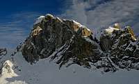 dante - West wall
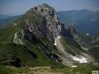 gabr1 - from the E, from Cima Avostanis/Blaustein
 West wall
 From Paluzza (S)
 From the North
 The view towards East
 Gamspitz from Timau
 Gamsspitz (credit: Hribi.net: triglavski)
 Lago Avostanis
 Blaustein / Cima Avostanis
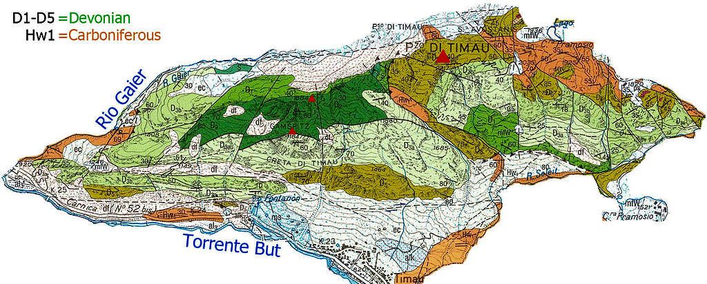
 Creta di Timau / Hocheck from Paluzza
 North around Creta
 Lago Avostanis
 Remnants of WW1
 dante - marmot
 dante - Casera Palgrande di Sopra
 ganesh70 - Casera Pramosio