Trip Overview
Background
This trip, perhaps not very notable for much of the community here at Summit Post, was special to me for a few reasons. #1. It was my first backpacking trip with my 2 best friends (Alex and James; they had a combined 1 backcountry night between them prior to this). #2. It was my first attempt at planning an entire trip's travel and logistics, route planning, escape/medical considerations, food/water/gear planning for people (my experience thus far has been as a soloist). These factors weighed heavily on my choosing Diamond Peak and this "southern route via Crescent and Summit Lakes." Background on Diamond Peak can be found at Summit Posts' very helpful page.
The year prior (2015) I abandoned a solo summit attempt (wildfires and poor planning) via a much longer route (Trapper Creek Trail to the NE, from Odell Lake). That particular trip was my first to the Cascades and Oregon. I loved the beauty and solitude of the area and it's an easy drive from Eugene (where Alex lives), which allows easy access. As a bonus, Odell and Crescent Lakes are nearby for frontcountry access and staging purposes (I chose Crescent Lake for this trip). This made the trip an easier sell to Alex who enjoys his creature comforts (running water, cold beer) and facilitated logistics overall. All these factors made it an easy decision to return for a summit run.
Trip Features
- 3 adults
- Non-intimidating profile with easy "bail out" (1 overnight but could be accomplished as a day hike; easy water access; easy car/frontcountry access)
- No particular gear, weather, altitude, or environmental concerns
Scouting Report
Weather
Early September in Oregon forecast good weather (no storms), day/night temps 70s/40s. Planned for night temps to low 40s. Exposure on the summit but otherwise forested.
Trip Plan
Day -1: Arrival Day
Fly/drive in to meet at Alex's house in Eugene, Oregon. Check gear and food, divide among the packs. Review maps and itinerary.
Day 0: Travel/Cabin Day
Drive from Eugene to Crescent Lake (< 2hrs) where a cabin is already reserved. "Acclimatize" for the rest of the day. Sleep early for pre-dawn start.
- Sleeping Altitude ~ 4,800'
Day 1: Summit Day
Early start because we have a 6.5 mile drive to the trailhead on an unimproved forest service road (FR398/6010 from Crescent Lake west towards Summit Lake/PCT); none of us had driven that route or type of road before and weren't sure if a Subaru Outback would handle it (it would be fine).
Trailhead (Pacific Crest Trail) to campsite (Rockpile vs. Marie Lake), lunch, drop off extra gear, then on towards the summit.
Turn off PCT to the unmarked "Climber's Trail" to the false summit then summit. Back to camp.
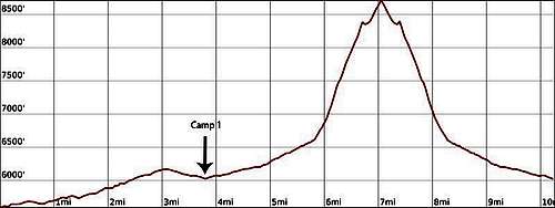
![Diamond Peak S Approach D1 Profile]() Day 1 Profile (Scout)
Day 1 Profile (Scout)
Overall Day 1 would be easy/moderate. The initial Leg 1 (TH to Camp) is ~ 4 miles and ~ 700' gain. Easy route along the PCT, West turn onto the Marie Lake Trail, then find/pitch camp. This was a built in "safety point" just in case morale for the summit was low; it was critical that we all summited together or not at all. If it was decided to abandon the attempt for any reason at least we were lakeside and could relax without feeling like the trip was a loss. It was also beneficial in that we could go on to summit Day 1 (Plan A) or plan to summit and return to the TH all on Day 2 (Plan B).
Leg 2 (Camp to Climber's Trail) is another ~ 2 miles/+700' along the PCT. Leg 3 (Climber's Trail) would be the "toughest section." It's unmarked but noted to be a "well worn booth path" with a cairn marking its junction with the PCT. The Climber's Trail is roughly 1 mile and 2000' gain over talus/scree to the false summit, then a short walk/scramble (~.25mi) to the true summit. Scouting photos and logs show a non technical hike with maybe some Class II/III route finding towards the summit. The return is a simple backtrack.
Day 1
- Just over 10 miles, ~3,400' gain, 2,950' loss
- Sleeping Altitude: ~ 6,000' (USGS topo marks Marie Lake @ 6,014'; Rockpile Lake @ 6,037')
Day 2: Return Day
Backtrack to trailhead/car, drive to Crescent Lake, home.
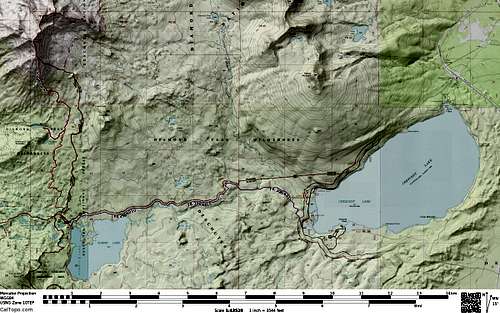
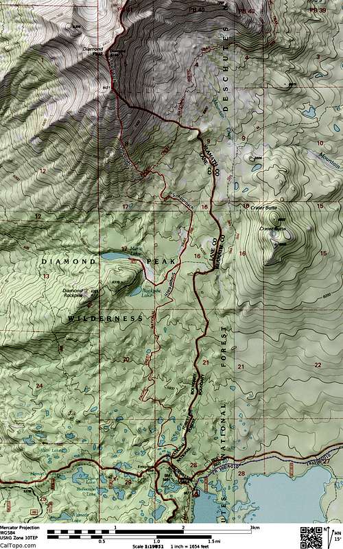
![Diamond Peak South Approach Overview Map]() Diamond Peak, South Approach; Overview Map
Diamond Peak, South Approach; Overview Map![Diamond Peak South Approach Route Map]() Diamond Peak, South Approach; Route Map
Diamond Peak, South Approach; Route Map
Trip Report
Pre-trip
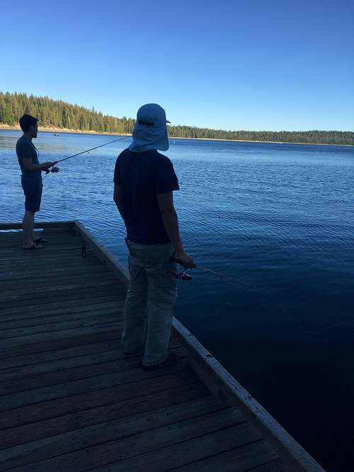
Everyone arrived as planned without issues, gear checked and remaining items (fuel, food) readied and car packed. Day 0 we left the house later than planned, took OR-58 southeast out of Eugene and about 1.5 hours later we arrived at Crescent Lake. Due to our late start there was less lounging time at the cabin (Hoodoo's Crescent Lake Resort) than we wanted, but we were still able to enjoy some fishing, beer, and a nice dinner.
![Diamond Peak from East shore of Odell Lake]() Diamond Peak from East shore of Odell Lake
Diamond Peak from East shore of Odell Lake![Fishing at Crescent Lake]() Fishing at Crescent Lake
Fishing at Crescent Lake- No hiking
- Sleeping altitude ~ 4,800' (4,000+ gain via car)
Day 1
We awoke on time (pre-dawn) for breakfast and final gear and weather check; however we deliberately waited for daylight to ensure we could safely navigate FR-368. This was my biggest worry from pre-trip planning because it was difficult for me to scout the road condition from the internet. Thankfully James' Subaru Outback handled it without problems (we went slow, it was brand spanking new). Many crossovers/CUVs/light SUVs could probably handle the road but just be aware: it's not a matter of traction (having AWD). It's the fixed rocky terrain that will punish low ground clearance cars.
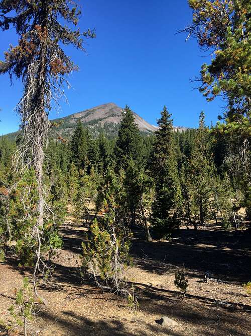
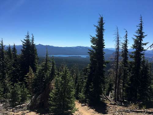
We arrived at the trailhead (PCT) parking lot (just NNW of Summit Lake), 2 other cars were there (could see 1 tent pitched near Summit Lake) but didn't see/hear any people. We hit the trail with high spirits just after 8 am. It was a nice easy hike through typical Pac NW conifer forest along the PCT. Occasionally Diamond Peak would come into view, peeking through the trees, a concrete reminder of our goal. The PCT junction with the Marie Lake Trail was clearly marked and we turned West towards Camp (sorry don't have a picture).
![Diamond Peak from the PCT]() Diamond Peak from the PCT
Diamond Peak from the PCTWe found a nice already well established campsite at Rockpile lake and in the interest of time decided not to continue to Marie Lake but quick pitched our tents, had a quick lunch, drop unnecessary gear and head to the summit. Our legs were feeling good and the weather was perfect (70s but still in the trees). Still hadn't run into anyone else on the trail. We left camp about 11:30 am (didn't note the time we arrived Rockpile Lake) heading East on the short Marie Lake Trail back to the PCT where we would turn North to continue towards the Climber's Trail and Diamond Peak.
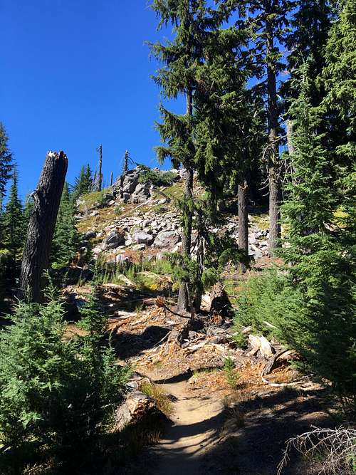
As we neared treeline things got more scrubby and we kept an eye out for the cairn which would mark our junction with the Climber's Trail. Alex, his first trip of the type, was incredulous that a "pile of rocks which would easily be knocked over by an animal" would serve as our navigational guide. My re-assurances fell on deaf ears but indeed the cairn was found intact and we continued on (FYI it's located around treeline; the PCT up until this point is heading roughly NW but after the junction with the Climber's Trail the PCT sharply turns off to the NE).
![PCT nearing treeline]() PCT nearing treeline
PCT nearing treeline![Alex Climber's Trail cairn]() Alex pointing out the cairn marking the Climber's Trail
Alex pointing out the cairn marking the Climber's Trail
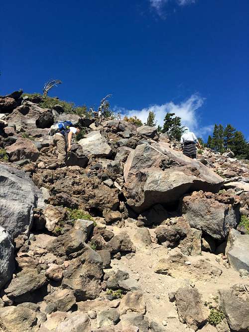
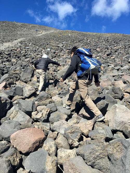
The Climber's Trail at first isn't well defined but multiple paths can be easily made (just point yourself "up" to the high point). There are multiple cairns along the route to help find your way but again, not really necessary. It's much steeper going than the PCT was, but its solidly within Class I territory. At the fringe of treeline the climb turns into its steepest part (and a solid Class II) but there's still good footing. It seems as if you're nearing the false summit but unfortunately you're not there yet; instead the aspect flattens and you're greeted with a field of talus and scree all the way to the horizon. The higher you get the looser and more sand-like the terrain becomes.
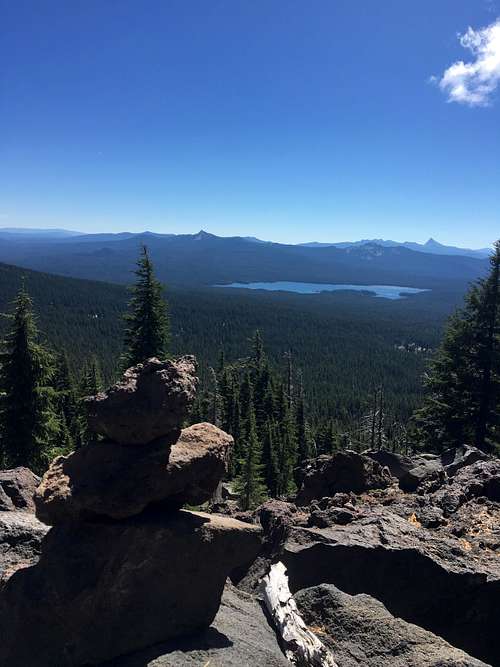
![Summit Lake from the Climbers Trail]() Summit Lake (looking south) from the Climber's Trail
Summit Lake (looking south) from the Climber's Trail![Cairn on Climbers Route]() One of many cairns along the Climbers Trail
One of many cairns along the Climbers Trail![Scrambling to the false summit]() Scrambling to the false summit
Scrambling to the false summit
The path is well worn and becomes clear; however you may opt for talus-hopping as it may make for faster travel. It was at this point we saw the first other people since the cabin at Crescent Lake; a small group of day hikers were making their way down "skiing" down the scree field (looked way more fun than trodding up). The weather continued to be perfect so we didn't feel rushed. This section is fully exposed; it would be a direct but annoying retreat to treeline if storms rolled in.
![Diamond Peak talus field]() Rock hopping up the talus field
Rock hopping up the talus fieldWe made slow but steady progress to the false summit (about 3 pm) without issue. The route across the "saddle" to the true summit was straightforward with minimal elevation gain, easy Class I/II terrain but one particular gendarme resulted in a short stretch of Class III scrambling. We reached the summit about 3:30 pm, took our pictures and put our names in the summit register.
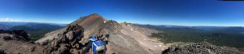
![Diamond Peak false summit panorama]() Panorama from the false summit (looking north to the true summit)
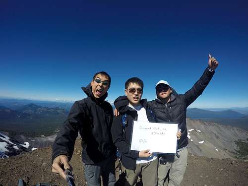
Panorama from the false summit (looking north to the true summit)![Diamond Peak Summit]() Arthur, James, Alex (L to R). Diamond Peak summit (8,744'), 9/11/2016
Arthur, James, Alex (L to R). Diamond Peak summit (8,744'), 9/11/2016
It was a simple backtrack down the Climber's trail, the PCT, and back to camp at Rockpile Lake for the night. We reached camp just after 6pm.
- No deviations from scouting report
- Successful summit; Diamond Peak (8,744'), September 11 2016
- Day Stats: Distance ~ 10.5 miles. Elevation: 3,100' gain, 2,700' loss.
- Sleeping altitude: ~ 6,000'
Day 2
Day 2 was uneventful, dawn wake up, breakfast, pack camp and head back to the car. Nighttime low 38F. Easy 4 mile walk back to the car.
Final Trip Data
Backcountry duration: 2 days, 1 night
Distance: 14.25 miles
Elevation Change: +/- 3,400'
Weather: Clear skies, no precipitation
Temps: High 70's/High 30's
Bugs: Minimal to none
Water Level: Seasonal average? Unknown; no water crossings, camp side lake was our source and seemed at average water level.
Note: Some of the data is off due to the different combinations of information sources (topo maps, GPS tracker) I spliced together. My GPS tracker was off for Day 1 Leg 1 (turned it on after lunch); Day 2 I left it on after we already got in the car and started driving which is the reason for the inconsistencies.
Permits and Logistics
Permits
No fee is required to hike/climb/camp, but a backcountry/day use permit ("self serve," free, filled out at trailhead) was required.
Some sites/trip reports indicate a permit was needed to park but I couldn't that up and we didn't use/have one.
Backcountry travel ethics and Leave No Trace principles apply, of course.
Frontcountry
Trailhead Directions
Your personal car/vehicle situation will largely determine this. I, not being from Oregon and having to fly in, was dependent on others for the drive in to the trailhead. There are other routes (to the summit in general) and to Summit Lake/trailhead, but the closest was from the east which is why I chose Crescent Lake as our frontcountry access point. From Hoodoo's (above) we simply drove west along Crescent Lake's north shore until we hit FR 398/6010 which continued directly west to Summit Lake and the Pacific Crest Trail head parking lot (roughly: 43.4632, -122.1341).
Final Thoughts
As planned, the trip was a complete success. We had a successful summit, everything went to plan, and we all enjoyed ourselves. It was challenging enough to feel satisfying and a perfect way to introduce others to the outdoors. It can be done as a day trip but makes for a great overnighter for families/kids or those wanting a less strenuous backpacking experience (especially if you only plan to head to Marie/Rockpile Lakes).
Comments
No comments posted yet.