
-
 5597 Hits
-
 86.37% Score
-
 22 Votes
|
|
Area/Range |
|---|---|
|
|
46.45356°N / 11.65284°E |
|
|
Hiking, Mountaineering, Trad Climbing, Scrambling |
|
|
Summer |
|
|
9478 ft / 2889 m |
|
|
Overview
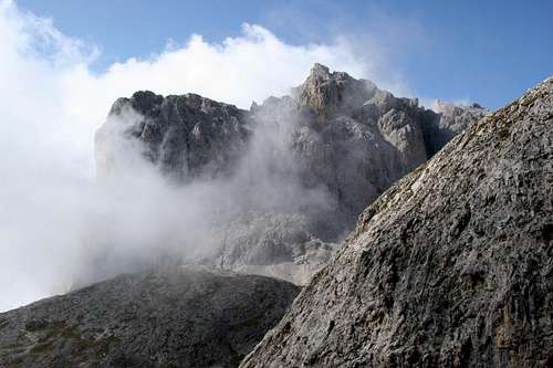
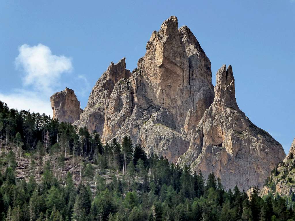
The Dirupi di Larsèc area is one of the eight subgroups that form the Catinaccio group in the Western Dolomites and is located in the Eastern sector of the group. It is an uncrowded area despite the proximity to the Val di Fassa, full of charm and with a wild character. Moreover it's the largest subgroup of the entire Catinaccio, divided into 5 main sectors:
- Cime di Scalierét
- Pope massif
- Dirupi di Larsèc main sector
- Crepe di Lausa
- Roe di Ciampiè
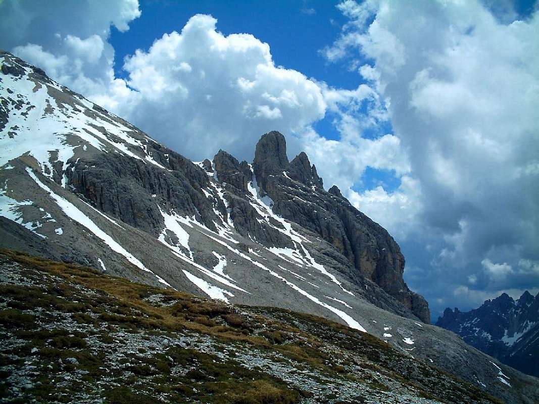
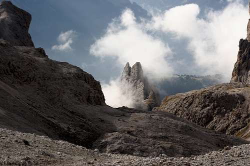
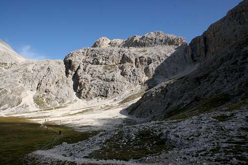
The borders of Dirupi di Larsèc are: to the North the Antermoia basin, to the East the Val d'Udai and the Val di Fassa, to the South the low Vajolet and to the West the high Vajolet. The ladin place-name "Larséc" could originate from the words "Lac Sec", meaning "dry lake", while the italian word "Dirupi" means "steep rocks". Due to its morphology with the presence of numerous gorges, steep rock walls and debris areas, the sub-group of the Dirupi di Larsèc generally has little wooded cover.
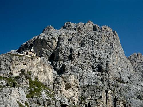
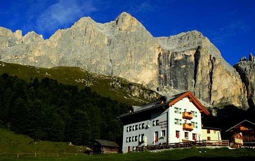
The Larsèc includes the third highest summits of the entire Catinaccio group, both 2889 meters high, Cima Scalierèt and Cima del Larsèc.The Gardeccia basin with its refuges is the fundamental reference point for the climbs in the Larsèc subgroup. From here there are two important paths that allow you to enter the Larsèc, the "Sentiero della Scalette" n. 583, with some equipped sections, which crosses to reach the Rifugio Antermoia Refuge and the "Sentiero Bepo de Medil", which climbs to the Pala di Mesdì, a panoramic itinerary traced in 1930 by Giuseppe Desilvestro, called Bepo de Medil. It starts behind the Rifugio Gardeccia with the indication "Panoramic path and reachs a plateau from where to the right enters a gully, then a second narrow one with an equipped section. Leaving the gully we proceed on easy rocks and then a ridge to reach the top called Pala de Mesdì 2758 m.
Getting There
As told, the best starting point to reach the summits of Larsèc is the basin of Gardeccia. The convenient shuttle service departing from Pera has unfortunately been suspended and so you can reach Gardeccia from Pera di Fassa by the 3 chair lifts leading to Ciampedìe (Vajolet1, Vajolet2, Ciampedìe) and, from there, in about 45' (trail 540) to Gardeccia Hut. Ciampedìe is also reacheable with a cablecar from Vigo di Fassa. You can reach Vigo and Pera di Fassa by car:
- From North: taking A22 motorway until "Bolzano Nord" exit. From there, follow the route SS241 "Grande Strada delle Dolomiti" via Passo Costalunga - Val di Fassa (distance 37km to Vigo, 40Km to Pera)
- From South: taking A22 motorway until "Ora/Egna" exit. From there, follow the route SS48 delle Dolomiti via Passo San Lugano - Val di Fiemme - Val di Fassa (distance 52km to Vigo, 55Km to Pera).
You can reach Vigo and Pera di Fassa also by bus:
From Bolzano/Bozen: click here to see timetable of bus service SAD From Ora/Auer: click here to see timetable of bus service SAD From Trento: click here to see timetable of bus service Trentino Trasporti
Closest railway stations: Bolzano/Bozen, Ora/Auer, Trento. See the Ferrovie dello Stato website for informations and timetables.
Cime di Scalierèt
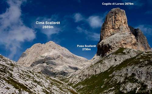
The Cime di Scalierèt occupy the NW part of the Larsèc subgroup and and is located adjacent to the sub-group of Antermoia. The main peaks of this arid and desolate sector are:
- Cima di Lausa 2880 m, an easy hiking summit situated nearby Passo d'Antermoia 2769 m, a pass connecting the Antermoia-Molignon subgroup with the Dirupi di Larsèc
- Cima del Larsèc 2889 m, another easy summit located on a rocky crest starting from Passo d'Antermoia
- Cògolo del Larsèc 2679 m, a seclued rocky tower
- Cima Scalieret 2889 m, a massive rocky structure located between Passo Scalierèt and Passo delle Pope.
This sector includes the two highest summits of the Dirupi di Larsèc, Cima Scalierèt and Cima del Larsèc, both 2889 m high.
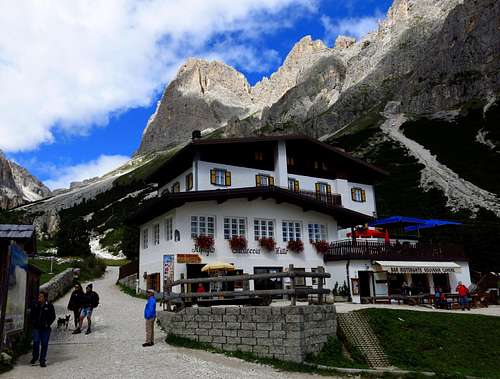
Massiccio delle Pope
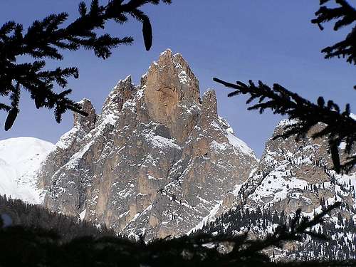
The small Massiccio delle Pope dominates the Vajolet and Preuss refuges and includes only the three distinct peaks which form the majestic rocky mass of the Cima delle Pope: Cima Nord 2780 m, Cima di Mezzo 2773 m and Cima Sud 2740. Here there are numerous climbing routes, even of high difficulty.
Main Dirupi di Larsèc
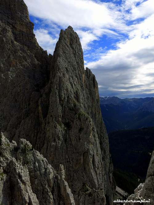
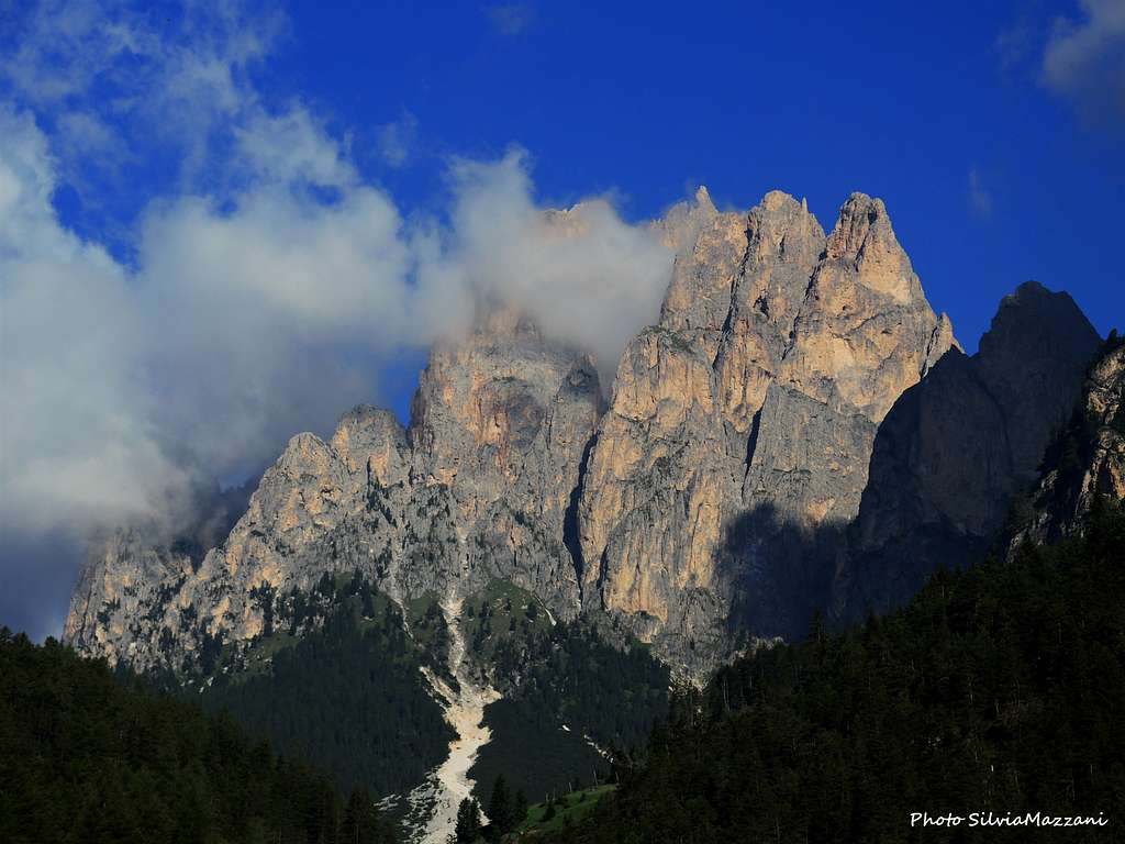
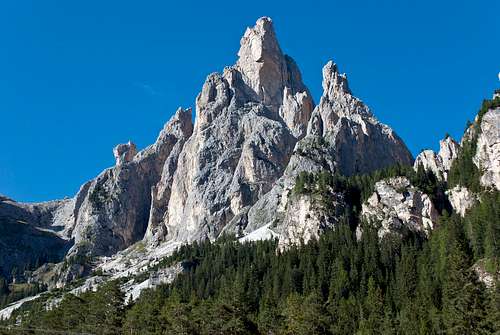
The main sector of Dirupi di Larsèc is located between Forcella delle Pope and Passo dello Scarpello. It is the finest, best known and most frequented sector of the subgroup, so much so that it gives its name to the whole subgroup. It is a complex and intriguing labyrinth of spiers and towers, including numerous peaks. The main summits are:
Palaccia 2602 m
Pala di Mesdì 2758 m
Punta Selvaggia 2670 m
Gran Cront 2778 m
Cront di Mezzo 2693 m
Piccolo Cront 2681 m
Pala della Ghiaccia 2423 m
Campanile Sotcrònt 2480 m
Pala di Socorda 2400 m
Guglia del Rifugio 2290 m
Campanile Gardeccia 2310 m
Becco dell'Aquila
Pala del Larsè 2730 m
Pala delle Fermade 2400 m. Some of these peaks are rather popular unlike the other sectors of the Larsèc, especially those ones most easily approached from Gardeccia, as Pala di Socorda, Campanile Gardeccia.
Crepe di Lausa
Ròe di Ciampiè
The Cime delle Ròe di Ciampiè are located in the NE sector of the Larsèc and include some of the finest peaks of the Larsèc, such as the Spiz delle Ròe di Ciampiè 2609 m and the Torre Rizzi 2485 m.
Red Tape
No particular restrictions in climbing and hiking. The road starting from Pera di Fassa to Gardeccia is open to the private cars as far as the small hamlet of Soial. Private cars beyond Soial are not allowed.
Natural parks
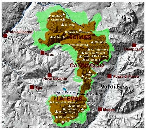
The Dirupi di Larsèc subgroup is located inside the Natural Park Sciliar-Catinaccio and Latemar. This area, shared between the provinces of Bolzano and Trento, is one of the nine mountain systems of the Dolomites acknowledged as UNESCO World Heritage Site. It is one of the most important systems worldwide for the study of the stratigraphy of the Triassic, in reason of the plenty of fossils on Alpe di Siusi, the relationship between carbonate and volcanic sediments, and the fact that the outcrops are easily accessible.
The Catinaccio group forms a series of peaks and sharp needles showing the movement of an island which sank into the sea 240 million years ago. More info about Dolomiti Unesco World Heritage here:
in the article by Silvia Mazzani: Dolomites living mountains
- on the Unesco Official web-site: Unesco
- on the Fondazione Dolomiti Unesco web-site: Fondazione Dolomiti Unesco
When to climb
Summertime (from June to the end of September)
Huts and other accomodation
Rifugio Gardeccia 1949 m
Rifugio Stella Alpina 1950 m
Rifugio Vajolet 2243 m
Rifugio Preuss 2243 m
Meteo
Meteo Trentino
Dolomiti Meteo - Trentino
Guidebooks and maps
The most up-to-date climbing guidebooks are:
"Arrampicare sul Catinaccio e dintorni" by Mauro Bernardi, Ed. Athesia, 2013
“La nuova guida del Catinaccio” by Antonio Bernard, Ed. Mediterranee, 2008 – A wide selection of the Catinaccio group climbing routes
"Arrampicare Dolomiti Nord-Occidentali
"IV grado Dolomiti Occidentali" vol. I by Emiliano Zorzi, ed. Idea Montagna 2011
"IV grado Dolomiti Occidentali" vol. II by Emiliano Zorzi, ed. Idea Montagna

|

|

|

|

|
Other climbing guidebooks:
"Dirupi di Larsèc" by Dante Colli - Gino Battisti - Tamari Editori in Bologna, 1981
“Catinaccio” by Dante Colli and Gino Battisti - Tamari Editori in Bologna, 1984
Choosing among all the books regarding Catinaccio group, for information we mention the old classic but long-lost guide:
"Sassolungo, Catinaccio, Latemar", Arturo Tanesini - Guida dei Monti d'Italia, ed. CAI-TCI (1953)
and also a fine hiking guidebook:
"Gruppo del Catinaccio" by Luca Visentini, Ed. Athesia (1979) also in German with the title "Rosengarten"
Another updated and excellent guidebook describing all the hikes and the Normal routes to the hundreds of summits of the whole range, with a lot of pictures, topos and very accurate maps is: "Gruppo del Catinaccio" by Andrea Gabrieli, Luca Visentini Editore (2010)
- Maps
Rosengarten-Catinaccio Latemar - 1:25.000 sheet - Compass
Val di Fassa e Dolomiti Fassane - 1:25.000 - sheet 06 - Tabacco
Sciliar/Schlern Catinaccio/Rosengarten Latemar-Regglberg - 1:25.000 - sheet 029 - Tabacco