
-
 8074 Hits
-
 71.06% Score
-
 1 Votes
|
|
Route |
|---|---|
|
|
37.63058°N / 119.03257°W |
|
|
Hiking |
|
|
Summer |
|
|
Half a day |
|
|
class 1 |
|
|
Overview
Why might you want to take this route to the summit? (1) the trail is good, (2) great views, (3) partial shade, (4) you can take the gondola down in minutes rather than walk, (5) it provides a good introduction to the Mammoth area, (6) it can be combined with a trip to Devils Postpile National Monument.
Getting There
First, download the Mammoth Visitor’s Guide so you can see what I’m talking about (see external links section). I also recommend you stop at the Mammoth Visitor’s Center on the way in to Mammoth town to pick up a paper copy as the guide is rather long at 148 pages and the paper copy is easier to use. You might also want a separate map of the town of Mammoth, as well as whatever else might strike your fancy. The Visitor’s Center is roughly 3.75 miles after the turnoff towards town on highway 203 and will be on the right.
If you’re car-camping there are also a couple of campgrounds near there that are centrally located, “New Shady Rest CG” and “Old Shady Rest CG”. See External Links section to make reservations.
Now, continue on up to the Adventure Center, roughly another 6 miles and 1,200 feet elevation gain up Minaret Road (still hwy 203) from the Visitor’s Center. Watch for a large sign in town directing you to make a right turn. The Adventure Center is a hub where the gondola goes up the mountain, where you can catch shuttles to town or the Postpile, rent bikes, get food and lodging, etc. For this trip I’m recommending you park your car where the gondola starts, take shuttles to where the trail starts, hike the trail to the top of the Mountain, then take the gondola back down to your car to complete your trip. If desired, you can also take the shuttle from there to Devils Postpile National Monument.From the Adventure Center take the “Bike Park Shuttle” back down to “The Village”. Walk across the street and transfer to the “Lakes Basin Trolley”. These rides are FREE and run every half hour, but double check in your Visitor’s Guide and ask people anyway just to make sure.
Take the Lakes Basin Trolley out to the store at Twin Lakes. Walk past the picnic area and across the bridge into the campground and keep going to the far side of the campground. The trail starts between sites #39 and 40. If you’re opting to drive to the trailhead and walk both up and down, there is parking space for two vehicles near here. If occupied, you would likely have to drive back to the picnic area and walk to the trailhead.Route Description
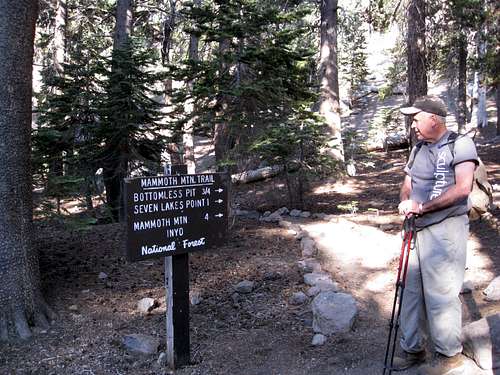
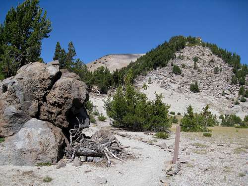
Dragon's Back Trail Head
The trail is roughly 3 miles long with 2,450 feet of elevation gain. It starts off in the forest with views of the lake. According to Mammoth Trail .org, this is “the shortest and steepest route to the summit of Mammoth Mountain.” I greatly prefer the trees and lakes on this side of the mountain to the hot, desolate, volcanic wasteland on the other side of the mountain. Allow 2 to 3 hours to get to the top.
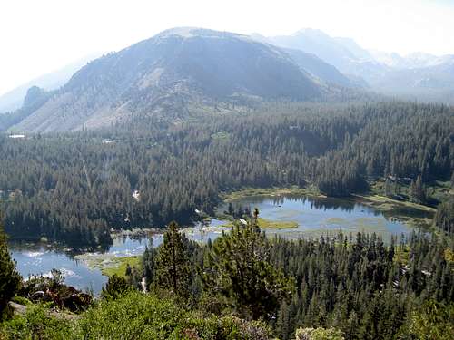
Twin Lakes from Trail
A refreshing view on a warm day.
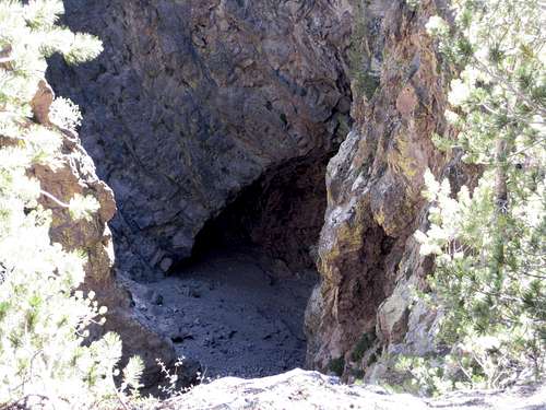
The Bottomless Pit
After around three quarters of a mile you will look down on something called the “Bottomless Pit” or the “Hole In The Wall”. This is a lava tube that skiers like to ski through. See the external links or google “lava tube Mammoth Mountain” to see skiers negotiating this feature.
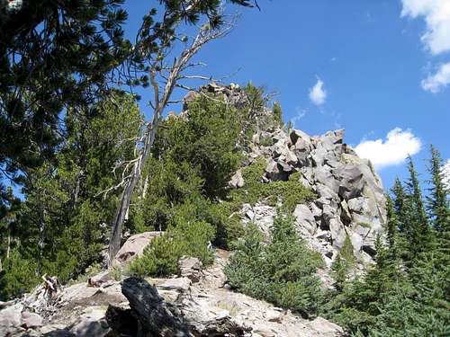
Hump on Dragon's Back
After switch backing up the mountainside for about a third of the distance, the trail emerges on the crest of the ridge, the "Dragon's Back", which it follows up to the summit area. From the ridge the views open up towards the town of Mammoth and the White Mountains beyond, and to the west towards the Minarets, Banner Peak and Mount Ritter.
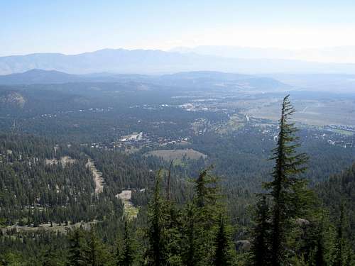
View of Town
View of Mammoth Lakes town from the Dragon's Back ridge.
Note, it was fire season in California when this picture was taken on August 9, 2015, so the view is a bit hazy.
Open Country
More open, alpine terrain in the upper reaches of the trail.
Mammonth Mountain is very popular with mountain bikers in the summer. For the most part they are well-separated from hikers, including on this trail, but about half an hour from the summit the trail does cross one bike route. Be very careful crossing the bike route - look all around before crossing, and don't linger at the intersection.
The building at the top of the gondola lift has amenities such as rest rooms, food, water, exhibits and even a movie. There may be a docent there as well to answer any questions you might have. It's a great place to enjoy a snack and take in the spectacular views.
At the time of this writing the charge in the summer for a round-trip gondola ride is $25. We were prepared to pay for our ride, but we asked a couple of staff and they said there was no charge to ride the gondola down. So climb aboard, relax, and enjoy the smooth ride down.
Essential Gear
No special climbing equipment is required, but this is a fairly steep hike; good hiking boots are recommended. If you commonly use trekking poles, you would probably want them here. Don't forget water, sunscreen, a hat, camera, etc.
External Links
Download a Mammoth Visitor’s Guide here (148 pages):
For a list of trailsin the Mammoth area go to:
For a direct link to Dragon’s Back Trail description:
http://mammothtrails.org/trail/48/dragons-back-trail/
For a direct link to a Dragon’s Back Trail map:
http://mammothtrails.org/trail/48/dragons-back-trail/#mapTab
For a trip report on hiking the Dragon’s Back trail by Rebecca:
http://calipidder.com/wp/2014/10/hiking-mountain-mammoth-mountains-dragons-back-trail/
To make campground reservations click on:
For videos of skiing the“Bottomless Pit”, a.k.a. “Hole In The Wall”:
https://search.yahoo.com/search?fr=mcafee&type=C111US679D20140802&p=lava+tube+mammoth+mountain
Yet another Mammoth website for general information on the Mammoth area: