
|
|
Mountain/Rock |
|---|---|
|
|
41.28350°N / 120.1997°W |
|
|
Modoc |
|
|
Hiking |
|
|
Spring, Summer, Fall |
|
|
9892 ft / 3015 m |
|
|
Overview
Eagle Peak is the highest one in the Warner Mountains, located in the northeastern corner of northern California, with the nearest town of any size being Alturas. Many who climb this peak do so because it is the high point of Modoc County. This is a non technical peak but the trail is 16 miles round trip with an elevation gain of over 4200 feet if hiked from the Falls Creek Campground. It is less mileage, about 10 or so if hiked from the Emerson lake campground. Either way, plan for most of a day and carry plenty of water during the warm summer months.The Warner Mountains are interesting in that they are both a spur from the Cascade range and could also fit in the category of being a desert Basin range.
The Warners are protected as part of a 70,000 acre wilderness area so wilderness regulations apply.
Peaks of the South Warner Wilderness area:
Seven high mountain peaks dominate the South Warner Wilderness. The three most distinctive are Squaw Peak, Warren Peak and Eagle Peak. Squaw Peak at 8,646 feet is a landmark at the north end of the Wilderness. Warren Peak at 9,710 feet marks the north central section. Eagle Peak towers at 9,892 feet in the south central section. Massive cliffs rising dramatically behind Patterson Lake to the north of Warren Peak are typical of the strikingly beautiful geography in the Wilderness. (reference U.S. Forest service)
For those who are interested in county highpoints, I should mention that Hat Mtn, the highpoint of Lassen county, is one that can be combined with a visit to this area.
With over 4300 feet of prominence, this peak comes in as the 14th most prominent peak in California. This alone makes this peak a very attractive prize and along with being the Modoc county highpoint, it is a good one to get. For lots of trip report links and a chance to view a log of those who have climbed Eagle Peak, check out the great peakbagger page for it.
Getting There
On U.S. 395, drive south from Alturas 20 miles to the town of Likely and turn east onto SR 64. From Reno, it is a long haul, 162 miles to Likely. Follow road 64 9 miles do a junction with SR 258 but stay left on SR 64. Another 3 miles will bring you to a signed intersection for Mills Creek Falls campground, where you take a right and go for another 1.7 miles to a pleasant campground where the trail starts from.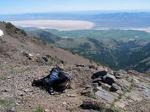
Red Tape
No permits required and there is an area where you can park at the TH in the campground area that allows permit free parking.
Fire permits are required if you intend to backpack and have a campfire. Permits are obtainable from the various ranger stations.
When To Climb / Routes & Trails
June through late October or when the snow flies. It gets hot in this area in the summer time and on occasion fire closures can stop you from entering the area. It would be wise to check with the local ranger district prior to making the effort to get to this rather remote area.
In addition to the Poison Flats Trail route, this mountain can be accessed from the Patterson Campground and Emerson Campground according to Gary Suttle, author of the California County summit book. He mentions that dirt roads access Patterson along the southern boundary of the Warner Wilderness area and that Emerson comes from the east.
See the routes offered on the left side of this page. I did it from the Falls Creek Campground but others have had good luck with the Emerson Lake campground side.
--------------------------------------------------------------------------------------
Emerson Lake Campground route as done by Bob Burd. See Bob's trip report and map HERE. Eagle Mtn was Bob's last California county highpoint. Congratulations Bob on a great California effort.
--------------------------------------------------------------------------------------
Camping
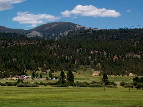
Falls Creek Campground is a nice wooded campground located at an elevation of 5700 feet. There are eleven spaces for tents and eight that will accomodate tents or RV's. This is a campground that is provided with water and modern vault toilets. No reservations necessary and the camping fee as of summer of 2004 was $6.00 per night. Now in 2015 you can expect that prices have gone up. There are trails that lead to the Falls and to Clear Lake, a lake that gets a fair amount of activity.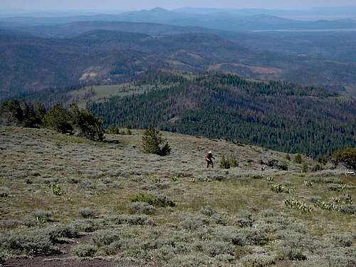
Emerson Campground:
A tiny campground of 4 sites that will accomodate either tents or RV's up to 16 feet in length. Picnic tables and fire grills are provided as is a vault type of toilet. No water. It is on the eastern side of the Warner Wilderness area and is accessed from the town of Eagleville. No fee noted for camping there at this time. From Eagleville, go south on county road 1 for one mile and turn right (west) onto county road 40 and drive 3 miles to the campground. The access rod is steep and can be very slick in wet weather. Trailers are not recommended.
Patterson Campground:
A small 5 site campground (tents or RV's up to 20 feet in length)
which is a no fee one at 7200 feet. Due to the elevation, this CG is rarely open before July Drinking water, picnic tables, fire grills and vault toilets are available. Access is either through Likely or Eagleville but I'll describe the Likely access.
Turn east at Likely on county road 64 and drive 9 miles to a fork. Take the right fork and drive an additional 16 miles to the campground which will be on the left.
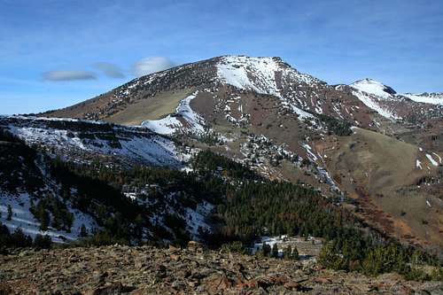
Keema's nice shot
Mountain Conditions
Modoc Ranger Station: 530-299-3215 is the place to call for up to date information.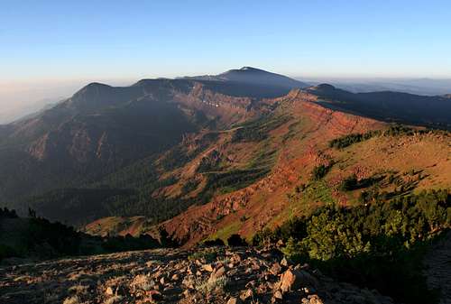
Another Bubba Suess gem
Weather information


Facts about the area
South Warner WildernessThe South Warner Primitive Area was created in 1931. With the passage of the 1964 Wilderness Act, the area became a formal part of the National Wilderness Preservation System. The 1984 Wilderness Act added more land, for a total of 70,385 acres.
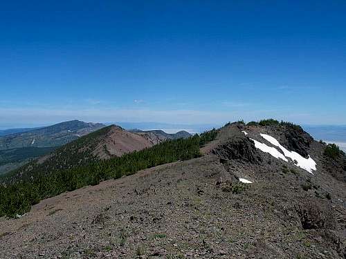
The South Warner Mountain Wilderness of the Modoc National Forest is located in the southeast section of the Warner Mountain Ranger District and is 18 miles long by 8 miles wide.The Wilderness has very steep slopes on the east side and moderate slopes on the west. A variety of vegetation adorns the area from high desert sagebrush and juniper to high alpine terrain. The Wilderness offers breathless vistas and the highest peaks in northeast California. All of Modoc County, much of Lassen County, and the Black Rock Desert in Northwestern Nevada are visible from higher areas. Mount Shasta and Mount Lassen can be seen in distant panorama.
A fire ravaged the area a few years back and the forest service has posted this information about it:
Blue Fire Burned into the South Warner Wilderness
Areas of the wilderness burned in the 2001 Blue Fire. Visitors are being asked to be cautious when traveling in burned areas.
BE AWARE OF:
BLACKENED TREES; they could be weakened to the point of falling!
STUMP HOLES; A tripping hazard for people and livestock.
WIDOW MAKERS; fallen trees or branches hung up in other trees!
Prominence Peak
Eagle Peak is one of California's prominence peaks and it ranks #14 on this list (click here)U.S. Forest service trails info
The U.S. Forest service has put out this information about the trails in the South Warner Wilderness area:Summit Trail - 22.4 miles - Relatively flat, open large meadows to the west. Trail is windswept in bad weather. Beautiful view to the west and occasionally to the east. Water is available but not as abundant as Owl Creek Trail. Eagle Pass to Patterson Lake not much water. Pepperdine to Patterson Lake takes 4-5 hours.
Squaw Peak Trail - 5.86 miles - Short cut from Pepperdine to Owl Creek Trail without going to Patterson Lake. Trail generally goes downhill into Cottonwood Creek. Easy trail to hike. Pepperdine to Owl Creek is 4 hours.
Upper Cottonwood Trail - 1 mile - Connects Summit and Owl Creek Trails. Many switchbacks, fairly steep in spots. Good view of Devil's Knob from trail. Lower portion is abandoned towards Forest Boundary.
Owl Creek Trail - 15.23 miles - Rugged broken topography intersects trail. Much up and down terrain. Plenty of water. Trail goes from basin to basin. Trail runs down over the east side of the rim, so most views are eastward. Linderman Lake, Owl Creek Basin, Raider Basin and Eagle Basin are points of interest. Access from Emerson, Summit or Squaw Peak Trails.
Mill Creek Trail - 8.36 miles - Fairly flat along Mill Creek until close to Poison Flat. Water and campsites available along trail. Fishing is good. Easy access from Soup Springs Trailhead and Campground which has a corral and hitching post.
Pine Creek Basin Trail - 4.64 miles - Uphill from entry point, runs along the creek at the bottom then opens into a big basin about halfway up. A few small ponds along the trail. Fishing is fair. Entry point to Patterson Lake takes 4-5 hours.
Slide Creek Trail - 1.85 miles - Connects Mill Creek to Summit Trail. Uphill. Plenty of water and camping. Not used much.
Poison Flat Trail - 5.91 miles - Uphill and ties into East Creek Trail. Very steep to Summit Trail. Located in timber and edge of meadows. Not much water or campsites near the top.
East Creek Trail - 5.58 miles - Downhill from entry point. Heavy timber, lots of water, not many campsites. Good fishing in East Creek.
North Emerson Trail - 4.37 miles - Steep with lots of switchbacks. Timbered trail except near top by North Emerson Lake. Fishing poor in North Emerson Lake. Limited campsites near trail, access to Natural Bridge. Ties in with Owl Creek and Summit Trails. Campground to North Emerson Lake takes 3 hours.
South Emerson Trail - 1.5 miles - Heavy timber throughout trail length. Access to South Emerson Lake, but trail is not defined. Fairly flat, slightly downhill to the southeast.
Bear Camp Trail - 3.63 miles - Upper portion from Bear Camp downward is narrow and flat. Receives heavy soil erosion onto trail. Most of trail is in timber. Only trail from which Natural Bridge can be seen. Very little water or camping along trail.
Trail Loops
For an overall wilderness experience, travelers can make an entire loop from Pepperdine to Patterson using the east side trail system one way and the west side trail system on the return trip. This loop may take seven days or longer to complete, covers over 50 miles of trail, and seldom retraces an area. While the west trail is fairly flat, the east trail is rather steep.
The Summit Trail runs 27 miles from Pepperdine in the north, to Patterson Meadow just off the southern border of the Wilderness. It approaches the top of Squaw Peak, passes by Patterson Lake, skirts the western flank of Eagle Peak, then follows the 8,000 foot ridge of the Warner Mountains for more than 15 miles. The scenery is magnificent! Numerous spur trails lead to gleaming glacial lakes and grassy meadows. The cool mountain weather usually inhibits the mosquito population, but insect repellent is recommended.
Combinations of trailheads and trails can provide from 5 to 70 miles loops with little or no area covered twice. See the Trailheads and Trails brochure and the Wilderness map for specific information. The South Warner Wilderness map shows length and difficulty level for each trail. It is advisable to also carry USGS topographical maps of the area.
For up to date information on any of the above trails should be obtained from the forest service.
External Links
- Eagle Peak
Adam Helman's trip report
Bubba Suess - Dec 31, 2008 3:56 pm - Voted 10/10
Another route to summitDean, I added another route to the top of Eagle Peak. This one comes in from the east and is six miles shorter than the Poison Flat trail. I also added some shots of Eagle Peak from the north and east. Hope this helps!
Dean - Dec 31, 2008 7:12 pm - Hasn't voted
Re: Another route to summitGreat news Bubba. I thought Bob Burd was going to add that route as he pretty much has it in his trip report (on his site). A nice addition, thank you.