
|
|
Route |
|---|---|
|
|
39.42850°N / 106.0875°W |
|
|
Off Trail Hike |
|
|
Half a day |
|
|
Class 2 Hike |
|
|
Approach
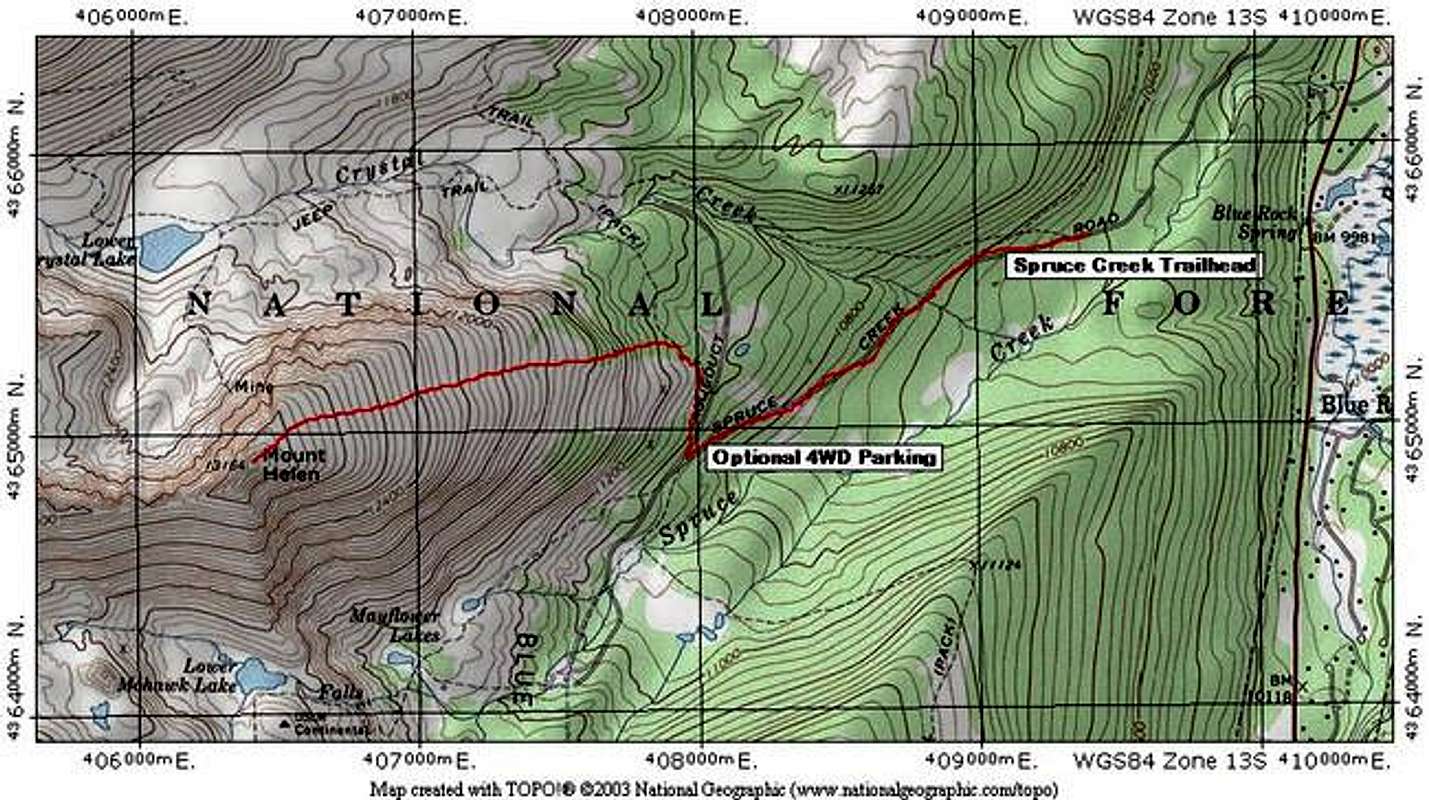
Begin at the Spruce Creek Trailhead.
Spruce Creek Trailhead: 10,440 feet.
From Hoosier Pass, south of Breckenridge on Colorado 9, go 7.6 miles north to the well-marked Spruce Creek Road. There is also a sign here that says "The Crown." Turn onto the Spruce Creek Road, and follow it for approximately 2 miles to an obvious parking area. Park 2 Wheel Drive vehicles here. Winter and Spring snow closure will also be here. This road does not typically melt out until mid-June.
4 Wheel Drive vehicles can proceed 1.1 miles up the Spruce Creek road to a gated closure on the Aqueduct Access Road (see route info below.)
Route Description
Refer to the TOPO map below for this route description.
Begin at the 2WD Spruce Creek Trailhead at 10, 440 feet. Follow the Spruce Creek road for 1.1 miles until you find a right (north) turn on an Aqueduct access road. This Aqueduct access road is private and gated. 4WD vehicles may drive to here, and find an appropriate parking spot.
From the gated Aqueduct access road, find signs for the Wheeler Trail. There should be wooden signs near the turn for the Aqueduct road. Follow the well-trod Wheeler Trail for 0.3 mile until you are directly below Mount Helen's East Slopes.
From here, you are approximately 1 mile from the summit. There is no established trail from here to the summit. When you leave the Wheeler Trail, climb steeply through forest to treeline. The best way to negotiate this terrain is to find a steep gully that leads to treeline from 11,300 feet to 11, 500 feet, however, it is not necessary to find this gully. This area is the steepest part of the climb.
From treeline, go directly for the summit. Look for climbers' trails here and try to avoid creating your own new trail. The most traveled area here is the shallow gully that draws water and snowmelt off of the summit. It will be obvious.
Mount Helen's summit is an airy perch. Take care not to fall near the west or south sides.
Round Trip Mileage: 5.1 miles
Elevation Gain: 2,700 feet
Summit Coordinates: N39 25.714 W106 05.247
(Thanks to skiitswitch for summit coordinates)
Essential Gear
For summer and fall, standard dayhike gear is all that is necessary. Ensure that you have a map and compass.
For winter and spring, climbers will want snowshoes or skis to negotiate this area. An axe is probably unnecessary. Use your discretion.