
-
 10056 Hits
-
 91.45% Score
-
 35 Votes
|
|
Mountain/Rock |
|---|---|
|
|
49.29998°S / 73.07482°W |
|
|
Patagonia |
|
|
Mountaineering, Trad Climbing, Sport Climbing, Ice Climbing, Big Wall |
|
|
Summer |
|
|
6407 ft / 1953 m |
|
|
Overview
El Mocho 1953 m
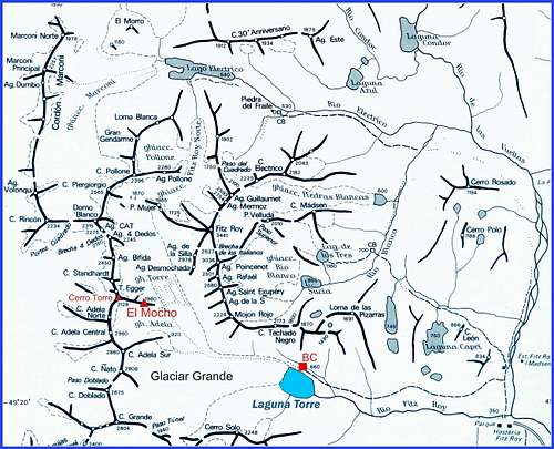
El Mocho is a massive tower lying at foot of the famous Cerro Torre East Face. As its huge neighbour, El Mocho is located in Parque Nacional Los Glaciares, Patagonia, and belongs to the Cerro Torre – Cordòn Adela Group, a magnificent chain lined up between the Brecha Cuatros Dedos to the North and the Viedma Glacier to the South. This group counts some ice-capped mountains, as Cerro Doblado, Cerro Ñato and Cerro Adela to the South, and some outstanding granite spires, as Aguja Bifida, Cerro Torre, Torre Egger, Punta Herron, Cerro Standhardt, Torre della Media Luna, to the North. These marvelous granite peaks are well known not in reason of their height, but in reason of their stunning shapes, their difficult technical climbs and the frequently adverse weather conditions.

El Mocho is the tallest of all these mountains and together with the Media Luna Tower is the most accessible peak from the Cerro Torre Base Camp. The East Face orientation and the proximity of Cerro Torre make it one of the best wind protected places of this chain. Moreover, its stunning grey wall, rising for about 500 meters of excellent granite, makes El Mocho a magnificent rock paradise. Quite an attractive destination for climbers coming from all the world! Moreover, the summit of El Mocho reserves one of the best view over the massif. We have the impressive West faces of Fitz Roy, Aguja Guillaumet, Aguja Poincenot, Aguja de la Silla, Aguja Desmochada, Aguja Saint Exupery, Aguja de la "S" just in front of us.

|

|
Getting There
Road access
The approach trek to El Mocho starts from El Chalten, a small mountain town in Argentina, Santa Cruz Province, on the riverside of Rio de las Vueltas. The village offers some basic shops, phone, internet facilities and accomodations such as camping and beds. At the entrance of El Chalten there is a Park Office, where trekkers and climbers have to register and obtain permits.
From El Chalten it starts the trail to Cerro Torre and Cerro Fitz Roy, so during the summer season there is a lot of tourists, trekkers and alpinists.

The village is located about 230 Km. North to El Calafate, the real gateway to Los Glaciares National Park, and the trip requires about 4 hours, on paved road (daily buses). El Calafate provides all modern facilities and all price accomodations ( estancias, cabins, camping, hotels). The town is situated on the south shore of Lake Argentino, about 320 km North-West from Río Gallegos (5 hours drive on good paved road; daily regular bus services). One can fly directly to the Calafate Airport or, alternatively, fly to the most important Rio Gallegos Airport (daily flies from Buenos Aires) and then drive for about 300 Km along National Road n. 5 to Calafate.
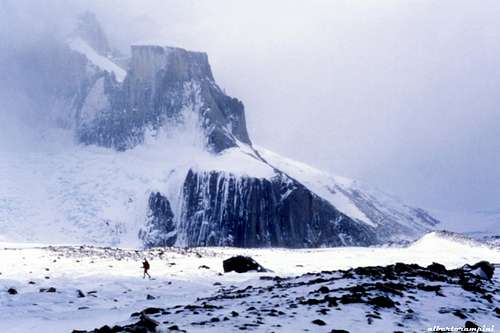
El Mocho from the Glaciar Grande |
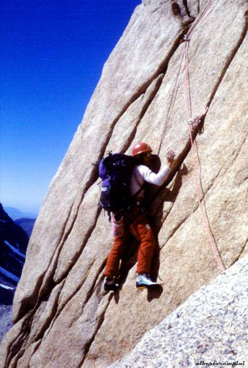
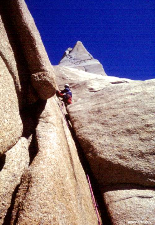
Fine cracks on El Mocho East pillar |
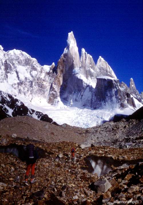
Walking approach From El Chalten a good path, following Rio Fitz Roy valley, leads to Bridwell Camp and Maestri Camp at Laguna Torre (camping place), from where a “mirador” can be reached: from here it's possible to enjoy a spectacular view on the impressive glaciers and peaks (Cerro Torre, Cerro Adela, Cerro Ñato, Cerro Doblado). The trail requires about 2,5 hours by walking. From the “mirador” a thin trail leads down on Glaciar Grande, which is crossed diagonally rightwards to gain the base of the massive tower.
Approach trail on the moraine |
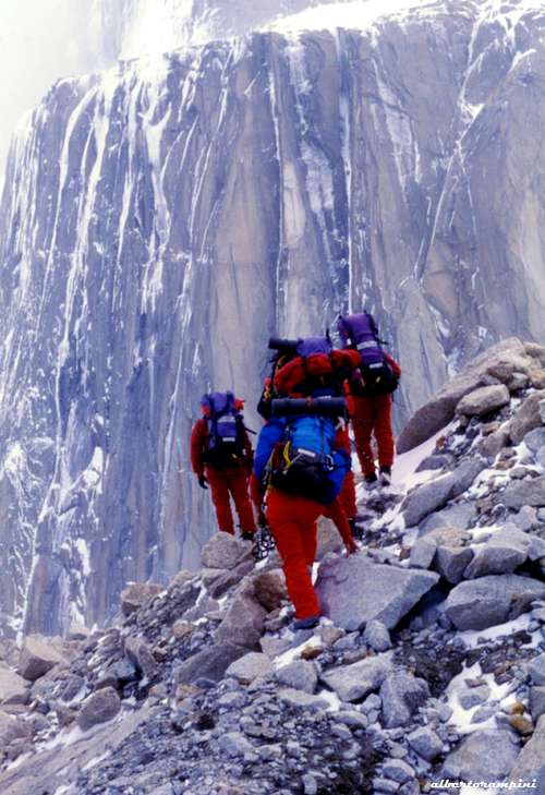
Reconnaissance after a snow storm |
History
El Mocho I ascent Jim Bridwell (USA) – R. Stszewsky (Australia) climbing the SE Pillar 28 Feb 1978
El Mocho II ascent Gian Carlo Grassi – Roberto Pe – Mauro Rossi (Italy) climbing the East ice-gully 18 Jan 1986
Route “Bizcochuelo” (East Face) I ascent Gian Carlo Grassi – Roberto Pe – Mauro Rossi (Italy) 7 Dec 1986
Route “Grey Yellow Arrow” (North Face) I ascent Silvio Karo - Francek Knez – Janez Jeglic (Slovenia) and R. Pe (Italy) 11 Dec 1986
Route “Via di sinistra al Pilastro Est” I ascent Monica Malgarotto – Alberto Rampini – Maurizio Venzo (Italy) 28 Oct 1987
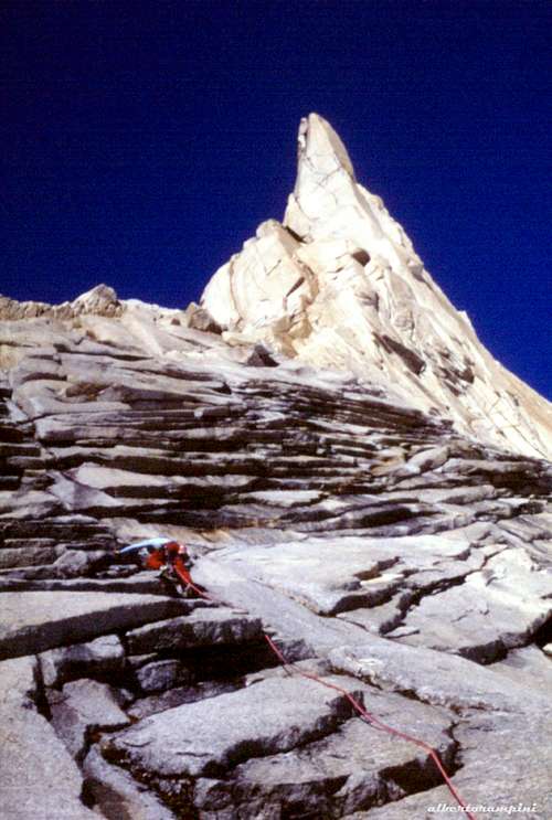
Starting to climb El Mocho East Pillar |
Exciting granite climb |
Routes oveview
El Mocho main routes from left to right:


East Face (from left to right)
- Voie des Bénitiers 7b+ (6c C1), 400 m. Daniel Anker and Michel Piola (Switzerland), 4/1/1989
- SE Spur 6b+, Jim Bridwell (USA) and Robert Staszewski (Australia), 28/2/1978
- Todo o Nada 85°, 350 m. Gian Carlo Grassi, Roberto Pe and Mauro Rossi (Italy), 18/11/1986
- Via di sinistra al Pilastro Est (Left Route on East Pillar) 6b, 350 m. Monica Malgarotto, Alberto Rampini and Maurizio Venzo (Italy) 28/10/1987
- Bizcochuelo 6b A1, 400 m. Gian Carlo Grassi, Roberto Pe and Mauro Rossi (Italy) 6-7/12/1986
North Face (from left to right)
- Grey Yellow Arrow 7a A0, 450 m. Janez Jeglic, Silvo Karo and Francek Knez (Slovenia), Roberto Pe (Italy), 10-11/12/1986
- Little Big Wall 6c A4, 450 m. Jean Marc Clerc, Rémy Duhoux and Vasken Koutoudjian (France) 25/1/1996
- Dulce de Leche 7a 400 m. Tadej Kriselj and Luka Kranjc (Slovenia) 1/2013
- Frader Pisafe 6c+, 400 m. Ermanno Salvaterra and Adriano Cavallaro (Italy) 28/12/1993
- Greeting from Bad Men 6a, 95° 400 m. Jörn Heller and Robert Jasper (Germany) 14/11/1994
- Reggae Time 6a A1+, 400 m. Alejandro Garcia, Mario Rinkevicz and Stephen Whewell (Argentina) 30/1/1996
- Anita 6b+, 400 m. Martin Laguna and co.(Argentina) 1/2005
South Face
- Back to the Front 6a+ A4, 400 m. Steve Gerberding and Jay Smith (USA) 2/1992

Red Tape
El Mocho is located in Los Glaciares National Park (Parque Nacional Los Glaciares), Santa Cruz province, Argentina, one of the most spectacular mountain area in Patagonia, on the border with Chile and Torres del Paine National Park. Los Glaciares National Park is a federal protected area and covering an area of 726,927 ha it's the second largest national park in the country. It was established on 11 May 1937 and in 1980 it was declared a World Heritage Site by UNESCO - UNESCO INFO
The name of the park refers to the huge ice cap in the Andes range, feeding 47 large glaciers, of which 13 flow to the Atlantic Ocean. The ice cap is the widest outside of Greenland and Antarctica. Climbing permits are required in the National Park Office at the entrance of El Chalten. The permits are free, with the only requirement for the climbers to provide their names and the peaks they are attempting to climb Take care of nature as usual in the natural sites and particularly within the boundaries of all the natural parks. Carry out everything you bring in and help to conserve the beautiful landscape!

|

|
When to Climb
The best time to climb goes from November to late February, the local summer, being the region located on the Southern hemisphere.
Meteo
Guidebooks and maps

"Patagonia Terra Magica per alpinisti e viaggiatori" Gino Buscaini and Silvia Metzeltin, Dall'Oglio Ed.
External Links