|
|
Mountain/Rock |
|---|---|
|
|
20.41119°S / 41.7995°W |
|
|
Alto Caparaó |
|
|
Hiking, Mountaineering, Bouldering, Scrambling |
|
|
Fall, Winter |
|
|
8432 ft / 2570 m |
|
|
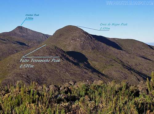
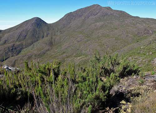
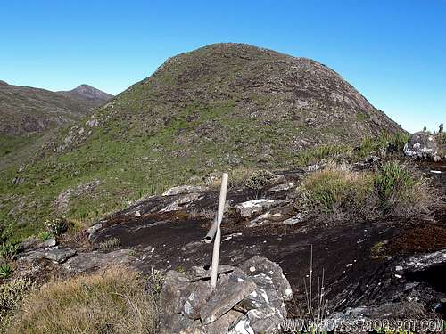
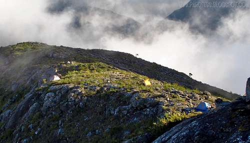
Falso Tesourinho Peak (false little Treasure Peak) is a secondary summit of Cruz do Negro Peak actually, in Serra do Caparaó, inside Caparaó National Park. This is like the second easiest mountain just like Cruz do Negro inside the park, despite the fact there some trails and cairns to see the way to the summit you don't really need them, a short walk up awaits you to reach that summit. It's a smaller mountain compared to the others, but with fantastic views. It is quite hard to find water points at the trails, just on Terreirão camp site - 2.370m at the Minas Gerais trail and at Casa Queimada camp site - 2.160m at Espirito Santo trail.
The route: There is a good and well defined route for this mountain. First of all you have to reach Cruz do Negro summit. From that summit you walk straighfoward to the mountain. First descend Cruz do Negro, ascend it with no problem (which has a cross at the summit).
From Belo Horizonte - The Caparaó National Park is 330 km from Belo Horizonte (MG). The access from Belo Horizonte (MG) to Alto Caparaó (MG) is done integrally in asphalted highways. Leave Belo Horizonte (MG), by the highway BR-262, towards Vitória (ES), until the city of Manhuaçu (MG) (280 km from Belo Horizonte). After the entrance of Manhuaçu (MG), in BR-262, take, to the right, the highway for Manhumirim (MG) and Presidente Soares (MG). In Presidente Soares (MG), take, to the left, the highway for Alto Caparaó (MG).
From Rio de Janeiro - The Caparão National Park is 430 km from Rio de Janeiro (RJ). The access from Rio de Janeiro (RJ) to Alto Caparaó (MG) is done integrally in asphalted highways. Leave Rio de Janeiro (RJ), by the highway BR-040, towards Belo Horizonte (MG), until the city of Três Rios (RJ) (123 km from Rio de Janeiro). Take, to the right, the highway BR-116, towards Salvador (BA), until the city of Fervedouro (MG). In Fervedouro (MG), take, to the right, the highway for Carangola (MG). In Carangola (MG), take, to the left, the highway for Presidente Soares (MG). In Presidente Soares (MG), take, to the right, the highway for Alto Caparaó (MG).
From São Paulo - The Caparaó National Park is 910 km from São Paulo (SP). The access from São Paulo (SP) to Alto Caparaó (MG) is done integrally in asphalted highways. Leave São Paulo (SP), by the highway BR-381, until Belo Horizonte (MG) (586 km from São Paulo). Take, to the right, the highway BR-262, towards Vitória (ES), until the city of Manhuaçu (MG) (280 km from Belo Horizonte). After the entrance of Manhuaçu (MG), in BR-262, take, to the right, the highway for Manhumirim (MG) and Presidente Soares (MG). In Presidente Soares (MG), take, to the left, the highway to Alto Caparaó (MG).
From Vitória - The Caparaó National Park is 255 km from Vitória (ES). The access from Vitória (ES) to Alto Caparaó (MG) is done integrally in asphalted highways. Leave Vitória (ES), byr the highway BR-262, towards Belo Horizonte (MG). 15 km after the boundary of Espírito Santo and of Minas Gerais states, in BR-262, take, to the left, the highway to Manhumirim (MG) and Presidente Soares (MG). In Presidente Soares (MG), take, to the left, the highway to Alto Caparaó (MG).
To the south entrance, you should to search for the town called Pedra Menina, on the south border of Minas gerais and Espirito Santo states.
From the entrance of Caparaó National Park to Tronqueira ( The first campsite and the last parking lot,6 km of highway), you can do with your own car or a rented jeep (for rent in the city).
Don't bring drinks; Inflamable fuel; Knives, Fire arms and if you do not have apropriates equipments to camp, the guards advise you of some danger.
There is no electric power or snack bars inside of the park. Therefore, take the whole equipment that is needed, like flashlights, headlamps, stoves, food and proper clothing.
The trails are relatively easy, but for the unexperienced mountaineer it can become tricky, mainly after Terreirão (2370m) and Casa Queimada (2160m).
Taxes to visit and to climb Caparaó mountains
US$ 3 person per day to camp and US$ 6 for entry (once);
There is a parking lot at the trailheads: Tronqueira (West) and Macieira(South).
Minas Gerais side :
Tronqueira – 1970m
The first campsite by Minas Gerais side on the route to the summit is called Tronqueira, and is 8km from the park entrance – uphill all the way, a hike that takes about three hours, or two if you’re a seasoned walker. You’re rewarded by stunning views, as the road winds its way out of forest into the alpine zone, with panoramic views of the Caparaó valley below. The trail culminates at Tronqueira itself, where a viewing platform has been built to allow you to appreciate one of the finest views in the country, as the hills far below recede to the jagged horizon. Just before you get to Tronqueira, a second trail to the left takes you to Cachoeira Bonita (Beautiful waterfall - 81m high), where the José Pedro stream, which forms the state border between Minas Gerais and Espírito Santo, plunges eighty metres down a rockface into a thickly forested gorge; another viewing platform allows full appreciation of the Nature’s spectacle. The campsite area accepts around 50 tents.
Terreirão – 2370m
Halfway to the summit you come to Terreirão – 2370m, the second official campsite and a good spot for lunch. A path to the right leads to a point overlooking a valley dominated by two mountains, the rocky crags of Pico do Calçado – 2821m to the left, and Pico do Cristal – 2769m to the right, both only a few meters shorter than Pico da Bandeira, and with trails leading up them if you felt so inclined – though only to be attempted if you are camping at Terreirão, or you will find yourself still on the mountain at nightfall. Fill your water bottle at Terreirão, as there is no drinking water between here and the summit. This is the best campsite on the trail by this side, wild views, security, protected by the National Park guards. 1,5 hours from Pico do Calçado.
This camp can take up to 120 tents!
Option "B":
High forbidden camp nearby the summit of Cruz do Negro Peak. Camp at 2.616 m. Best point to start the hike for that mountain.
Espírito Santo side
Macieira campsite – 1800m
After 3km of Pedra Menina entrance, beside of São Domingos river, has a plain and big area for many tents, hot showers, sanitary and bathrooms. The acces is by asphalted road. From this camp as possible to see Pico do Calçado and another great mountains of Caparaó.
Casa Queimada – 2160m
8 km after Pedra Menina’s entrance. The access is by land road. A good choice to camp to climb Pico do Calçado by night. There are drinking water, bathrooms and hot shower with solar heating. 2 hours from Pico do Calçado.
If you are an expert mountaineer, you can bivouac at the top of the range, choosing a protected place to sleep. If the weather is rainy, stay on the oficial campsites.
![]()
Click at the image for weather forecast page.
To hike/ climb is a dangerous activity and requires proper equipment and clothing, the owner of this page cannot be blamed by injuries caused to anyone who read this page for its info about the mountain, and eventually got hurt by doing so with reckless behaviour or bad weather conditions.
Paulo Roberto Felipe Schmidt – AKA: PAROFES
The biggest brazilian website about climbing and mountaineering, for which I'm a columnist:

The route: There is a good and well defined route for this mountain. First of all you have to reach Cruz do Negro summit. From that summit you walk straighfoward to the mountain. First descend Cruz do Negro, ascend it with no problem (which has a cross at the summit).
Getting There
How to Arrive to the west entrance:From Belo Horizonte - The Caparaó National Park is 330 km from Belo Horizonte (MG). The access from Belo Horizonte (MG) to Alto Caparaó (MG) is done integrally in asphalted highways. Leave Belo Horizonte (MG), by the highway BR-262, towards Vitória (ES), until the city of Manhuaçu (MG) (280 km from Belo Horizonte). After the entrance of Manhuaçu (MG), in BR-262, take, to the right, the highway for Manhumirim (MG) and Presidente Soares (MG). In Presidente Soares (MG), take, to the left, the highway for Alto Caparaó (MG).
From Rio de Janeiro - The Caparão National Park is 430 km from Rio de Janeiro (RJ). The access from Rio de Janeiro (RJ) to Alto Caparaó (MG) is done integrally in asphalted highways. Leave Rio de Janeiro (RJ), by the highway BR-040, towards Belo Horizonte (MG), until the city of Três Rios (RJ) (123 km from Rio de Janeiro). Take, to the right, the highway BR-116, towards Salvador (BA), until the city of Fervedouro (MG). In Fervedouro (MG), take, to the right, the highway for Carangola (MG). In Carangola (MG), take, to the left, the highway for Presidente Soares (MG). In Presidente Soares (MG), take, to the right, the highway for Alto Caparaó (MG).
From São Paulo - The Caparaó National Park is 910 km from São Paulo (SP). The access from São Paulo (SP) to Alto Caparaó (MG) is done integrally in asphalted highways. Leave São Paulo (SP), by the highway BR-381, until Belo Horizonte (MG) (586 km from São Paulo). Take, to the right, the highway BR-262, towards Vitória (ES), until the city of Manhuaçu (MG) (280 km from Belo Horizonte). After the entrance of Manhuaçu (MG), in BR-262, take, to the right, the highway for Manhumirim (MG) and Presidente Soares (MG). In Presidente Soares (MG), take, to the left, the highway to Alto Caparaó (MG).
From Vitória - The Caparaó National Park is 255 km from Vitória (ES). The access from Vitória (ES) to Alto Caparaó (MG) is done integrally in asphalted highways. Leave Vitória (ES), byr the highway BR-262, towards Belo Horizonte (MG). 15 km after the boundary of Espírito Santo and of Minas Gerais states, in BR-262, take, to the left, the highway to Manhumirim (MG) and Presidente Soares (MG). In Presidente Soares (MG), take, to the left, the highway to Alto Caparaó (MG).
To the south entrance, you should to search for the town called Pedra Menina, on the south border of Minas gerais and Espirito Santo states.
From the entrance of Caparaó National Park to Tronqueira ( The first campsite and the last parking lot,6 km of highway), you can do with your own car or a rented jeep (for rent in the city).
Route
Very easy and fast from Cruz do Negro summit, which btw is the easiest mountain of the park. Can't miss it.Red Tape
The Caparaó National Park has hard rules.Don't bring drinks; Inflamable fuel; Knives, Fire arms and if you do not have apropriates equipments to camp, the guards advise you of some danger.
There is no electric power or snack bars inside of the park. Therefore, take the whole equipment that is needed, like flashlights, headlamps, stoves, food and proper clothing.
The trails are relatively easy, but for the unexperienced mountaineer it can become tricky, mainly after Terreirão (2370m) and Casa Queimada (2160m).
Taxes to visit and to climb Caparaó mountains
US$ 3 person per day to camp and US$ 6 for entry (once);
There is a parking lot at the trailheads: Tronqueira (West) and Macieira(South).
When to Climb
Add When to Climb text here.Camping
Arriving in Caparaó National Park, you can choose where to camp.Minas Gerais side :
Tronqueira – 1970m
The first campsite by Minas Gerais side on the route to the summit is called Tronqueira, and is 8km from the park entrance – uphill all the way, a hike that takes about three hours, or two if you’re a seasoned walker. You’re rewarded by stunning views, as the road winds its way out of forest into the alpine zone, with panoramic views of the Caparaó valley below. The trail culminates at Tronqueira itself, where a viewing platform has been built to allow you to appreciate one of the finest views in the country, as the hills far below recede to the jagged horizon. Just before you get to Tronqueira, a second trail to the left takes you to Cachoeira Bonita (Beautiful waterfall - 81m high), where the José Pedro stream, which forms the state border between Minas Gerais and Espírito Santo, plunges eighty metres down a rockface into a thickly forested gorge; another viewing platform allows full appreciation of the Nature’s spectacle. The campsite area accepts around 50 tents.
Terreirão – 2370m
Halfway to the summit you come to Terreirão – 2370m, the second official campsite and a good spot for lunch. A path to the right leads to a point overlooking a valley dominated by two mountains, the rocky crags of Pico do Calçado – 2821m to the left, and Pico do Cristal – 2769m to the right, both only a few meters shorter than Pico da Bandeira, and with trails leading up them if you felt so inclined – though only to be attempted if you are camping at Terreirão, or you will find yourself still on the mountain at nightfall. Fill your water bottle at Terreirão, as there is no drinking water between here and the summit. This is the best campsite on the trail by this side, wild views, security, protected by the National Park guards. 1,5 hours from Pico do Calçado.
This camp can take up to 120 tents!
Option "B":
High forbidden camp nearby the summit of Cruz do Negro Peak. Camp at 2.616 m. Best point to start the hike for that mountain.
Espírito Santo side
Macieira campsite – 1800m
After 3km of Pedra Menina entrance, beside of São Domingos river, has a plain and big area for many tents, hot showers, sanitary and bathrooms. The acces is by asphalted road. From this camp as possible to see Pico do Calçado and another great mountains of Caparaó.
Casa Queimada – 2160m
8 km after Pedra Menina’s entrance. The access is by land road. A good choice to camp to climb Pico do Calçado by night. There are drinking water, bathrooms and hot shower with solar heating. 2 hours from Pico do Calçado.
If you are an expert mountaineer, you can bivouac at the top of the range, choosing a protected place to sleep. If the weather is rainy, stay on the oficial campsites.
Weather forecast
This website I believe some of you guys know already, it is one of the best to see mountain weather forecast, and it has on its list Bandeira Peak, and this one is good to check the weather forecast for all the park: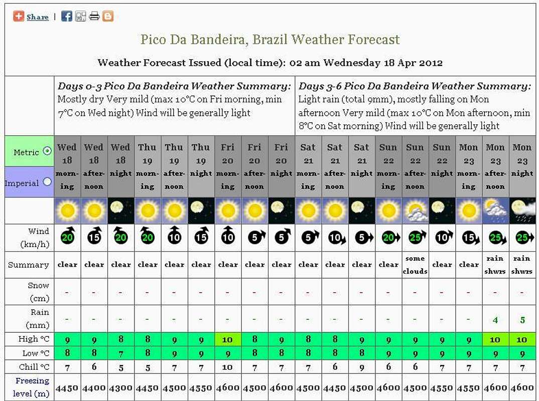
Click at the image for weather forecast page.
Legal issues
To hike/ climb is a dangerous activity and requires proper equipment and clothing, the owner of this page cannot be blamed by injuries caused to anyone who read this page for its info about the mountain, and eventually got hurt by doing so with reckless behaviour or bad weather conditions.
Paulo Roberto Felipe Schmidt – AKA: PAROFES
External Links
My youtube channel: www.youtube.com/parofes - Now with 270+ videos online!The biggest brazilian website about climbing and mountaineering, for which I'm a columnist:


