
-
 2135 Hits
-
 71.06% Score
-
 1 Votes
|
|
Route |
|---|---|
|
|
41.29741°N / 3.25659°W |
|
|
Hiking |
|
|
Spring, Summer, Fall, Winter |
|
|
Half a day |
|
|
Overview
Loma de las Piquerinas is an excellent hike for all people. If you have childrens, this is a good opportunity to start to walk together. However, be careful in winter and autumn, when fog and blizzard are commons (in this case, it's a good idea to carry a GPS).
Getting There
See the main page of Loma de las Piquerinas to more information.Route Description


Cross the center of this graceful black village to take the beginning of a cemented track that gets to Cantalojas (22 kms further on). You’ll see a slate stone (that indicates that village) and a tourist placard.
It’s time to follow a forest trail on the right that goes down to the bed of a stream (arroyo de las Cabezadas), 20 meters further on.
There is a junction; take the forest trail on the left, that ascends to two visible deposits of water, 500 meters further on, in the middle of an area covered by two species of bushes named “jaras” (rock rose or cistus; scientific name: Cistus ladanifer and Cistus laurifolius). This is a typical plant of these mountains, that covers deforested places (it’s worthy of remark that the oakwoods and beechwoods of these mountains were used during the last decades to make charcoal. In spring (May to June) presents large and spectacular white flowers.
Continue going up slowly, passing next to those deposits (one of them is gray) that stay on right. The forest trail enters into the “jaral” (ground covered by the aforementioned “jaras”) and traces a curve. We reach a little oakwood (Quercus pyrenaica) and we’ll see a new junction, located next to a stone wall. Take on the left and cross a little stream (dry in summer), going up to a false col, visible from Majaelrayo.
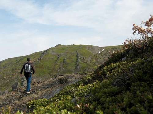
The forest dissapears; lonely oaks cover the ground, where the “jaral” and another bush appears: the “gayuba” (Arctostaphyllos uva-ursi). This is a creeping plant that presents green leafs all year round. The forest trail traces a new curve, skirting a more pronounced slope (west face of Campachuelo). Continue to the end of this forest trail, that skirts as far as a grassy col, that presents splendid views to the other side (north). Before getting to this col, we’ll cross the source of Rechichuelas stream (arroyo de Rechichuelas in the maps) that is the last oportunity to catch water (there are two metal manhole cover where the water is taked to the aforementioned deposits of water of Majaelrayo). “Gayuba” covers like a gigantic green carpet the ground and the forest trail ends; you’ll see wheel traces on right (SE) that guide to a smooth hillock, where some vertical slate stones resemble a “dragon back-bone”. There are several paths between the “gayuba” that guide to this hillock. Following to the south by this hillock there is a smooth descent to the large col of La Mujer (collado de la Mujer, 1.801 m.).
This grassy col presents nice views to the vertical north face of Loma de las Piquerinas. From this col, continue by the path that ascends to Campachuelo, 100 meters above the col, covered by meadows where goats graze in summer.

-To the south, the north face of Ocejón (2.048 m.)
-To the west, the remote mountains of Sierra de Guadarrama: Peñalara (2.430 m.) and Cabezas de Hierro (2.383 m.) are the main. Likewise, the nearby tops of Sierra del Rincón: Tornera (1.866 m.), Centenera (1.810 m.) and Porrejón (1.827 m.).
-To the north, the main summits of Sierra de Ayllón: Tres Provincias (2.129 m.), Cerrón (2.199 m.), Pico del Lobo (2.273 m.) and Buitrera (2.046 m.).
-To the east, the rest of Loma de las Piquerinas, that appears like a broad and rocky hillock that presents two 1.930 and 1.933 heights and another remote geodesic vertex: Campo (1.921 m.).
This is our last target. To go across these lonely places is a wonderful experience: peace and silence in a landscape similar to the lunar surface, in one of the areas with less density of population in Europe. It's not a crowded hiking at all! Follow the crest to the east, passing those heights before arrive to Campo, that presents a visible column and a huge cairn, this last one made in slate stones. From Campo (1.921 m.) the views extends to the norht-east to the remote Sistema Ibérico. The main summits that you can see are: Moncayo (2.316 m.), Pico de Urbión (2.271 m.) and Muela de Urbión (2.228 m.). To the east, in the background, the nearby Sierra del Alto Rey. Its highest top, Alto Rey (1.852 m.), presents visible military antennas.