
|
|
Route |
|---|---|
|
|
44.18690°N / 71.6114°W |
|
|
Hike |
|
|
Most of a day |
|
|
Class 1 |
|
|
Approach
GARFIELD TRAIL 4.8 miles one way
TRAILHEAD ELEVATION: 1500'
GARFIELD RIDGE TRAIL 0.2 miles one way (Scramble)
TRAIL INTERSECTION ELEVATION: 4180'
10 miles round trip
Take I-93 north to exit 36, Route 3 toward Twin Mountain. Stay on Route 3 until you see a sign for Gale River dirt road on your right just before the Gale River. If you pass the first intersection there is another road intersection across the Gale River which is better marked. (Gale River Road is closed for snowmobile travel in winter but is usually a plowed section off of Route 3 where hikers can enter). Take Gale River Road to the Garfield Trail parking area (fee).
If planning on summiting Mt. Garfield in winter be prepared to park along Route 3 due to the fact that the Gale River Road is closed to snowmobile travel. The distance in winter then rises to 12.3' miles
Route Description
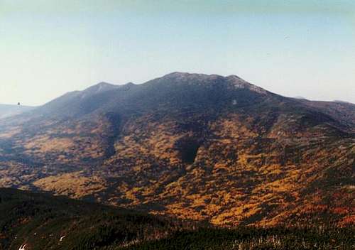
Mt. Lafayette from the summit of Mt. Garfield (10/1)
The Garfield Trail is amongst one of the easiest and least rocky trails in the White Mountains. It is also famous for one of the better views in the White Mountains, featuring a picturesque view of the entire Pemigewasset Wilderness.
It's gentle to slighly moderate grade is famous amongst many of the locals for its great view with barely any effort. Though it does rise from 3000' from base to top and a double digit mile climb, the vast bulk of this trail is so easy that your body won't believe it has traveled ten miles if even five miles. Though the last 0.2 miles (on the Garfield Ridge Trail) is steep you won't even feel it. This is a great mountain for many first time eager Northeast 4000 foot peakbaggers to get in shape.
From the trailhead off Gale River Road (FR-92) (1500') the trail climbs a hill and travels through the typical northern hardwood as well as hemlock that are famous along the lower elevations of northern New England. At 0.7 miles the trail then swings down the embankment towards and head left on an old fire road. It then crossesd two brook (Thompson and Spruce Brook and a snowmobile trail (Caution: this can be confused for the Garfield if not paying attention. Keep focused on the more beaten path and keep your eyes on trail markings in this area.) The later at 1.2 miles recrosses the Spruce Brook and begins it gentle but steady climb up the mountains. It's continues it's gentle and steady climb until at 2.8 miles it reaches a ridge called Burnt Knoll, once a completely bunt out section. It descends slightly in this section that begins a gentle to moderate ascent through several switchbacks up to the cone of Mt. Garfield. The forest slowly becomes more coniferous as to head closer to Mt. Garfield. The trail reachs a blowdown patch at 4.1 miles, turn left and gentle continues it's ascent up the east side of Mt. Garfield. At 4.8 miles it reaches the Garfield Ridge Trail junction. From there The Garfield Ridge Campsite is 0.2 miles on your left and the summit of Mt. Garfield is 0.2 miles on your right. The last 0.2 miles is the hardest part of the trip, it consist of a steep and rocky ascent to the highest point of Mt. Garfield then a side trail leads to an easy scramble to an abandon fire tower foundation where some magnificent views await.
Essential Gear
Mt. Garfield is one of the easier high peaks to hike in the White Mountains. If you plan on hiking this mountain after the the mud season until the winter season begins then a pair of hiking boots, a warm jacket, a ton of water, food, and common sense is all that is required. Remember though that Mt. Garfield is rocky and the viewing area is very exposed. If a thunderstorm or other inclement weather threatens or persist turn back immediately. If hiking in late fall do be prepared for rapidly changing weather and strong possiblities of snow. Best to keep your eye on the weather forecast and be prepared for them just in case they fail you.
In winter snowshoes and crampons are required. Because of the large distance to the summit of Mt. Garfield from Route 3 in winter, Mt. Garfield is not as heavily traveled in winter. Snowshoes will do fine for most of the hike, but at the last steep pitch to the top of Mt. Garfield you will be glad you brought the crampons, or hating life with snowshoes. Also in winter dress for extra warmth for the summit of Mt. Garfield can be some ten to twenty degrees colder than the surrounding valleys and bring a sleeping bag and tent in case inclement weather occurs.
Miscellaneous Info
If you have information about this route that doesn't pertain to any of the other sections, please add it here.