
-
 9612 Hits
-
 72.08% Score
-
 2 Votes
|
|
Route |
|---|---|
|
|
39.98780°N / 9.32440°E |
|
|
Hike |
|
|
Half a day |
|
|
Walk-Up |
|
|
Approach
From the town of Fonni go south on SS389. After some 2km SP7 (a small side road) turns off left (south) and leads in direction Desulo. After 5km turn left (signs Monte Spada, Bruncu Spina). 7km will lead you to the trailhead which is not at the end of the road at the ski lift but rather some 1km before, where there is a dirt road to the right and a parking place to the left.Route Description
Elevation gain: 700m
Duration: 3h
Difficulty: Hike
Trailhead: 1km before the ski lift to Bruncu Spina
The ascent to Punta La Marmora is a long but relatively easy affair. From the trailhead 1km to the north of the ski lift to Bruncu Spina a maintenance road for the upper station starts on the right hand side of the road. Follow this road which first climbs north (i.e. away from the Gennargentu main ridge) but soon turns south heading for a pass just below Bruncu Spina, Sardinia's second highest mountain. Get through this pass and ascent Bruncu Spina from the south western side.
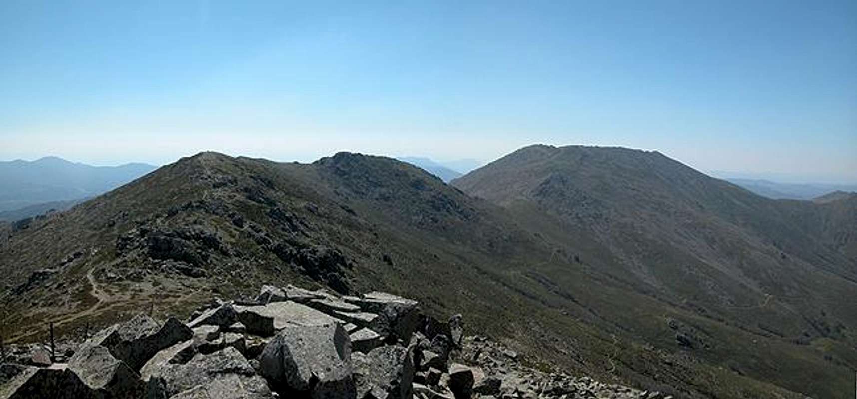
From Bruncu Spina you can already see the whole ridge towards Punta La Marmora, consisting of Punta Paulinu (1792m), Arcu Gennargentu (the pass which gave the name to the whole mountain range), Punta Sciusciu (1823m), Punta La Marmora (1833m) and Punta Florisa (1822m). Thus hou have four of Sardinia's highest summits in your sight, standing on the second highest one.
The trail now leads along the ridge (always to the west of it) over some minor bumps toward Punta Paulinu, an unspectacular knob. From here it descends to Arcu Gennargentu only to reach Punta Scisciu the most "impressive" mountain of the range. Here you could reach the summit by a class II scramble. The normal route however circles it and mounts it from south west.
Now a long descend into the pass Genna Orisa follows. In the pass the trail turns to the eastern side and finally ascends towards Punta La Marmora steeply. Once again on the ridge you can see the summit cross which you reach without any trail.
The cross region being rather crowded you can hike on towards Punta Florisa, the last of the high Gennargentu Mountains which offers you the complete view - like Bruncu Spina, only from the southern side.
 |  |  |  |
Alternative
 Crossing below Bruncu Spina - water source
 Towards the saddle below Bruncu Spina
Vid Pogačnik:
Because weather was not so good, we followed the path SW of the main ridge, which is the fastest ascent possibility for Punta la Marmora. By car you can reach Rifugio Desulo-Gennargentu, on good 1500 meters. From the mountain hut the road ascends in 2 steep turns some 50 meters and then goes horizontally almost to the saddle (good 1600 m) below Bruncu Spina. From there, continue crossing the (S) slopes of Bruncu Spina, first horizontally, then descending some 50 meters. You pass a few nice water sources, which may however in summer be dry. At the ravines of ex mountain hut the path turns up again and in good 15 minutes you reach Arcu Gennargentu (saddle). From there it's still some 30 minutes to the main summit of Punta la Marmora (as Gangolf described). This approach should take you less than 1 h 45 min of steady walk from the car to the highest point.
Vid Pogachnik - May 11, 2010 2:41 pm - Voted 10/10
Below the main ridgeBecause weather was not so good, we followed the path SW of the main ridge, which is the fastest ascent possibility for Punta la Marmora. By car you can reach Rifugio Desulo-Gennargentu, on good 1500 meters. From the mountain hut the road ascends in 2 steep turns some 50 meters and then goes horizontally almost to the saddle (good 1600 m) below Bruncu Spina. From there, continue crossing the (S) slopes of Bruncu Spina, first horizontally, then descending some 50 meters. You pass a few nice water sources, which may however in summer be dry. At the ravines of ex mountain hut the path turns up again and in good 15 minutes you reach Arcu Gennargentu. From there it's still some 30 minutes to the main summit of Punta la Marmora (as Gangolf described). This approach shoul take you less than 1 h 45 min from the car to the highest point. (I will post also 2 pictures, if you incorporate this text on the main page, you can embed them to the text.) Cheers! Vid
Gangolf Haub - May 26, 2010 4:44 am - Hasn't voted
Re: Below the main ridgeVid, can you add this description yourself? I'm not sure I understood where you came from and how you reached the ridge. Years back there was another SP member who told me there was a second better route but she never answered my request to detail it. Feel free to do all the changes you think neccessary as it has been 6 years since I went to Sardinia and my mind gets a bit foggy ---