Gora Narodnaya, "mountain of the people": To whom does the highest peak of the Urals belong?

Gora Narodnaya, "mountain of the people": To whom does the highest peak of the Urals belong?

Page Type Page Type: Trip Report
Location Lat/Lon: 65.03498°N / 60.11410°E
Date Date Climbed/Hiked: Aug 15, 2010
Activities Activities: Mountaineering
Seasons Season: Summer

Introduction

The Ural means for me the border of Europe and Asia – a completely arbitrary definition. The highest mountains of autonomous Russian republics belong to my field of interest: I „collect“ the highpoints of all European countries.

In the extreme north-east of Europe I find the Komi Republic – Республика Коми –, populated by the Komi people. Has anyone ever heard of the Komi? No? Don't worry, you don't differ from me. I have been raised in the Cold War and only know the West; this has an after-effect. For still today Europe is partitioned by an invisible divide: East of Vienna Asia creeps imperceptibly into the minds of people, exemplified with mere formalities: visa, registration slips, uniforms, police controls. I don't know, up to now, how to categorize Russia; and even the Komi!!?

Who are the Komi? What is the Komi Republic?

The Komi are a Finno-Ugric people. According to the census of 2002, however, they encompass only one quarter of the population of the Komi Republic, 60 percent are Russians. Among the approximately 1 million of citizens are also members of various ethnic groups of the former Soviet Union, most of them descendants of displaced persons that Stalin had recruited for constructing the railway line to Vorkuta, and of convicts from the notorious concentration camps.

„Komi“ is the name given to several groups of people in he area of the Komi Republic and beyond. Most Komi speak variants of Komi-kyv. A considerable number, however, use Russian – mainly or always. Traditionally Komi are foresters and farmers, hunters and fishers; nowadays many Komi work in industry and the service sector.

The Republic Komi was created and established between 1919 and 1921 on a territory of 416,000 square kilometers, which means it is 1.16 times as large as Germany, but consists largely of swamps and forest. The republic's capital is Syktywkar with about 230,000 inhabitants. Official languages are Komi and Russian; the signs on public buildings are bi-lingual. If you wish to study the republic and its institutions in greater detail, in particular the extent of autonomy that it „enjoys“, best begin with its constitution at http://85.rkomi.ru/ru/ORespublike/Konstitutsiya.html.

The highest mountain

Political maps of Russia, laid over geographical ones, show that the highest mountain of the Urals appears likewise to be the highest mountain of the Komi Republic: Gora Naroda or Gora Narodnaya, 1895 m high, translated as „Mountain of the People“, a name which has been obtruded on the mountain in 1927, when it was climbed first by the geologist A. N. Aleshkov and discovered as the highest of the Urals; the name is said to be bowdlerized from the corresponding Komi name „Nárada-iz“. Another name is „Poznurr“.

And already am I in the middle of planning. The experienced map dealer Jāņa sēta in Stabu iela 119 in the Latvian Riga provides an atlas of the Republic Komi with a collection of maps in the scale of 1 : 500,000. When I scroll through the pages of this atlas I cannot but shudder: Far and wide there are no roads in the area that I have eyed, except a few „зимники“ = zimniki, routes passable in winter, and „Тракторные“ = traktornye, tractor tracks through immense forests and swamps; without hesitating I will skip those, all the more since the nearest settlement is about 100 km away, air-line – in reality 170 km: Inta on the railway line Moscow – Kotlas – Uchta – Vorkuta. This railway connection is the only useful link to the Russian mainland.

But already at this preliminary stage I spot an interesting detail: As expected, the border of the Republic Komi to the Siberian Autonomous District of the Khanty-Mansijskij Autonomous District – Ханты-Мансийский Аьтономный Округ — runs across the г. Народная, however, not exactly over the summit, but past the summit within a short distance north west of it. The summit of Narodnaya is being shifted towards Sibiria. This immediately provokes the question: What then is exactly the highest point of the Komi Republic? It appears I will have to look out for it somewhere near the summit of Narodnaya; if this is true, I could catch both targets at one stroke. Intensive googling for something like „Самая высокая точка Республики Коми“ = highest point of the Republic Komi reveals only that, in fact, the border runs past the summit in a distance of half a kilometer, but where exactly the highest point lies and how high it is remains a mystery.

Yet this also means I have to get hold of even more detailed maps. A collection of useful ones in the scale of 1 : 100,000 have been generated by the Soviet general staff – Генералштаб, “Generalshtab“ – in times gone by; today they are on offer at the government-owned company Roskart – Federalnoje agenstwo geodesii i kartografii – Roskartografija (Federal Agency for Geodetics and Cartography) in 117997 Moscow, Uliza Krzhizanovskogo 14, Korpus 2. I recommend the map titled „Cеверная Народа“ – Number Q-41-97,98, issued in 1980. Caution: Roskart delivers, if at all, only at advance payment. My virus protection software warns their homepage http://roskart.gov.ru to be „attacking“.

More googling opens the direct access online: http://www.veslo.ru/maps.html and even better http://polarural.narod.ru/, in particular there the map at http://polarural.narod.ru/maps1/q419798_3.jpg. What do I see? The summit of Narodnaya lies about 600 m south east of its north west shoulder, across which runs the border. This north west shoulder appears a few meters higher than the nearby competitor to the north east, Gora Karpinskogo. The latter is considered the second-highest elevation of the Ural with 1803.4 m and lies directly on the border. In this respect I don't have to worry: There is no need for me to climb Gora Karpinskogo when looking for the highest point of the Komi Republic; I can do this rather within one and the same hike, directing with my route via the shoulder to the main summit of Narodnaya.

Another question I have not touched yet:

Who are the Khanti and Mansi?

Very simple: the people around the city of Khanty-Mansijsk. Perhaps fans of winter sports have already picked up the name from radio or TV reporters when ski and biathlon championships were held there.

The Khanti and Mansi, Finno-Ugric peoples, closest related to the Hungarians, are the titulary nations of this autonomous west Sibirian district. In fact, they no longer are but a small fraction of the population – each only around 1 percent; most inhabitants – three quarters of the population – are Russians, Ukrainians and Belorussians. This trend has even been reinforced after oil fields have been discovered and exploited. One thing is clear: Gora Narodnaya is – now undisputedly – the highest mountain of the Autonomous District of the Khanti and Mansi.


Access to Gora NarodnayaAccess to Gora Narodnaya: One approaches Narodnaya from the north, over flat boulder fields to the north west shoulder, situated above the „9“ of „1895.0“; from there one traverses via a flat saddle to the south east, up to the summit.

How get there?

Getting there is relatively easy, even if somewhat costly: I need a tourist visa for Russia (about 156 $-US), a flight from Frankfurt, Germany, to Moscow (about 400 $ both ways), a rail ticket from Yaroslavskij station in Moscow via Kotlas to Inta-1 (schedule of the Russian Railways at http://rzd.ru, train #s 021H and 22H, respectively, "Полярная стрела" = Polar arrow, travel duration 36 hours – there are more contemplative, even slower trains as well; on those you will experience the Russian life more directly and more intensively: 540 $ both ways in the soft „Kupé“ class), Registration with the local environmental authority (for I enter the National Park Yugyd-va), a daily fee for staying in the park and mediation fee for the park administration (together 100 $), a hotel room in Inta (30 $ per night in the shabby Gostinitsa Severnyaka in Gorki street 9, first and last house in the wild east), and finally the hardest item to „swallow“: transport with a high-wheel truck re-modelled to a bus, brand „Ural-Vachta“, from Inta to Baza Zhelannaya, the starting point for the hike („lust base“, 680 $ both ways). Last, but not least, also the stay there is to be payed for, again 30 $ per night, in the „Lux“ class, in a tidy room with access to a shower, alternatively half a dollar per night in a filthy shelter, kind of stable. The Baza Zhelannaya offers excellent meals and runs a small shop. All this can be more or less taken from the Internet prior to the journey, if one bothers to screen the site of the national park at http://www.yugydva.komi.com/index.php. Caution: The corresponding English language sites at http://www.yugydva.komi.com/?eng contain only part of the entire information!

Note: Only to facilitate better understanding I have given the prices in $; all is to be paid in roubles. And: Almost nobody along the entire way speaks a word of English! Some are technologically cutting-edge and have a laptop, enter their questions or remarks into Google Translate in Russian and shove push-button the translation into English under my nose. If I am lucky, something understandable will emerge. I can only recommend to take a prior 4-weeks intensive Russian language course before setting off to remote areas in Russia, for example at the Landesspracheninstitut der Universität Bochum, the first address in Germany for this purpose, http://www.lsi-bochum.de/. And this would mean sacrificing another 2,600 $; However, it will turn out that this money is well invested: Russia is large and there is great „danger“, that once you dip into a Russian adventure the country will make you addicted. You will then have a long-lasting, immense benefit.

A sufficiently detailed schematic map of the National Park Yugyd-va, indicating also the course of the access route to Base Zhelannaya, can be found at http://nordural.ru/article/yugyd_va/. So mentally mobilized, I can start.


Inta - Moscow on the railwayInta - Moscow: This is how a railway ticket in Russia looks like


Moskva - VorkutaMoskva - Vorkuta: Towards Stalin's GULag camps

Getting there

Actually everything is said already. Three days long crammed and cramped in a plane and a train compartment, either in the Плацкарт- („Platzkarte“- reserved seat) class, a circumscription for 2nd class, or in a 4-bunk double-decker compartment of the Купе = Coupé class, until I reach Inta. Between the two classes there is only a gradual difference; more important may be the choice of train, especially during the hot Russian summer months: either you sit in the „fast“ train, hermetically locked-up from fresh air (average speed 55.5 km/h) or in the only slightly more leisurely passenger train in which, however, you may open the windows (47.6 km/h). In either case there is free access to the central tea water boiler, made in DDR, and a lovingly lady conductor who will gently wake me up in the morning, half an hour before arrival in Inta.

Oldtimer bus # 101 takes me from opposite the railway station, 10 km away from the town center, to the spacious square enfolding around a concrete Lenin monument in classical Soviet style. No wonder: Inta was founded only in 1940 as a base for geological explorations; the name derives from the Nenets word for „place rich in water“.

From the bus stop „Rosto“ it is only a few steps to the administration office of the National Park in ulitsa Dzerzhinskogo 27 A – a sketch at http://www.yugydva.komi.com/?page=address.htm –, opening at 9 o'clock. The three ladies managing the office, Olga Viktorovna, Olga Vladimirovna und Ljudmila, act without delay and goal-orientatedly. Do I want to start my trip to Base Zhelannaya straight away right now or will I rather wait until tomorrow? Don't think long! Decide!

Fortunately one allows me to take a bit of time for investigating on the computer how the weather will develop over the coming days. The day after tomorrow shall be fine in Inta, it says, later followed by rain. The weather in Inta will not necessarily be the same as in the Ural, but I do not have a better basis for a decision. Consequently I opt for setting off tomorrow, all the more because then I can join a group, a factor that bears a twofold advantage: Not only will this keep the fare within reasonable limits, but it also offers the perspective for companionship. Mountaineering in latitudes short of the Polar Circle are serious undertakings; the height of 1,895 m corresponds to 2,895 in the Alps!

The driver of the Ural-Vachta, „bisnessman“ Aleksandr Veniaminovich Nakvaskin, appears at the hotel on time. The 170-km rattling ride on the jungle and tundra track crossing the Kozhym river takes 7 hours. Then I get dropped off above the tree line at the Base Zhelannaya, whuile the driver idly returns to Inta. Never would I have been able to cover the distance on foot: 1) too long, 2) the river too deep to wade across.


Up north through the TaigaTrain through the Taiga towards NE


The 3 Graces of Yugyd-vaThe 3 Graces of the administrative branch office of National Park Yugyd-va

Ascent

The group chose to walk into another valley, so I am alone. The ascent, so one tells me, is not to be done within 1 day, therefore I must prepare for an open-air camping for one night. This is another reason why good weather is so important. The park ladies had suggested to take rubber boots, with profile; such boots I do have on, but do they reach high enough on my legs? One frowns: better would be boots whose legs reach over my knees. And water-tight trousers? Nope. Those I don't have.

At 4 o'clock sharp I set out from Base Zhelannaya. As the map indicates, my way towards Gora Narodnaya leads through the valley of the Balban'-yu for the first 6 km, on its right banks, along the lakes of Big and Little Balbanty. „Way“ seems an euphemism for a tractor track, in part nicely dry, but most of the time there is bottomless mud. For a while I am guided by the sharp pyramid of Gora Starucha-iz ahead of me – 1328 m. Then, it is already 9 o'clock, the track crosses diagonally over to the left bank – fortunately the Balban'-yu here is shallow enough to wade through without delay. At the other side it continues west-bound reasonably dry into a side valley. 2 km further on, the way crosses over the river in this side valley, too – this time the water reaches up to the upper rim of my boot legs. Thereafter the tractor track peters out towards west.

I must now keep a strict southern direction and head for the moraine that separates the tiny glacier rest of the Lednik Balban'-yu at the right hand side from the stream at the left. For a while it means exercising on its ridge across boulders, then I continue first over a grassy plain, afterwards over boulders again, until I reach the outflow of the lake with the altitude quote 1133.5. From here onwards the boulder fields will have a firm grip on me. It is 11 o'clock.

From now on there is no longer a visible trail to follow; I have to rely only on the map. Ahead, in SE direction, I let the sharply carved little valley left of me and climb a boulder-covered, humpbacked ridge. From above I see the broadly spread-out triumvirate for the first time, consisting of the central Gora Narodnaya and its north east and north west shoulders. Now I strive for the plateau in front of the bulky summit bulge, through the smoother upper part of the little valley – circumventing the barrier of a steep snowfield on its left side.

Advancing now becomes more and more troublesome. Carefully I dangle and twist across the almost endless boulder slope up the ridge that descends from the north west shoulder towards north.

Being a notorious highpoint collector I cannot omit, of course, the north west shoulder. I measure its height with GPS as 1821 – 1830 m and determine its coordinates with 65° 02.232'N 60° 06.121'O and claim without knowing better that this is the highest point of the Komi Republic. As expected, there is neither a triangulation post, nor a border marker. Towards W and S a face drops almost perpendicularly down into the valleys of the Manaraga – towards Europe – and the Naroda – towards Asia, respectively. At the same time I stand on the continental divide. 15 o'clock.

After a short rest I traverse the wide saddle with a wooden cross towards SE (1808 m, 65° 02.184'N 60° 06.301'E) and hurry up the slope to the main summit. Only in the last moment the summit insignia come into sight: the typical „Tur“, a pyramidal rack plated with aluminum-tin sheets and a series of plaques celebrating the 80 year anniversary of the foundation of the Komi Republic. The blue-green-white flag of the Komi Republic flutters at the bottom, too, completely misplaced as I, cunning fellow, know in the meantime that I stand here already on the territory of the Khanti and Mansi, in other words in Asia. The Khanti-Mansi flag would look the same, though, different from the Komi flag only by a white symbolic heraldic figure in the upper left corner..

The view is impressively alpine; especially the sawblade of the six summits, one behind each other, of the Manaraga in the west – 1663 m – and the sharp razor edge leading up to Gora Karpinskogo in the NE. In general, though, the mountains here in the pre-polar Urals are rather gently shaped: The ice age has covered and polished everything and has left its trace with limitless boulder fields. My GPS measures 1898 m and 65° 02.099'N 60° 06.846'E.


Through the Kozhym riverCrossing the Kozhym river
Arriving at Base ZhelannayaUnloading luggage at the Base Zhelannaya


Base ZhelannayaBase Zhelannaya


The  way  to Gora NarodnayaGora Starucha-iz leading the "way" through the valley of Balban'-yu
Morning glory at the foot of Gora Starucha-izMorning glory on the foot of Gora Starucha-iz


Gora Narodnaya in sightNarodnaya in sight


Far view westFar view west: Gora Manaraga with its six summits looks like a sawblade


Europe left, Asia rightEurope left, Asia right: The cross on the saddle between the north west shoulder and the main summit of Narodnaya divides continents, but not republics.


On the summit of Gora NarodnayaSummit insignia: the typical Russian triangulation marker


On the summit of Gora NarodnayaSummit insignia: a plaque commemorating 80 years Komi Republic

All reverse again

In the meantime it is 20 minutes past 4 p. m., and I do well to retire from the summit as fast as possible. Ascent and descent in one day appear manageable only for well-trained sportsmen. I feel like chased in a competitive race against time, for the weather threatens to deteriorate any moment. It is hard to stick to a straight direction in the complex heap of rocks; I must avoid by all means to descend, unintentionally, to the valley of Ozero Goluboe, the lake shimmering to the right below so seductively. If I ended up in the wrong valley, I would face a major catastrophy, because nowhere would be a settlement in reach, nowhere a road, nowhere an exit. Without GPS and good senses for orientation I could be lost. Rain or fog would be the least that I need now. But fortunately the weather remains stable. I manage to return until behind the moraine crest of this morning, call it a day at 8 p. m. – after a 16-hour battle – and throw my rucksack onto the dry meadow about at 65° 05.5' N 60° 07.8' E, spread out my water-tight bivouac sack, stuff it with my down sleeping-bag and slip into it in full gear, even with my rubber boots on – I don't want to risk fiddling about for my boots in the darkness of the night, awoken by the rain!

Nevertheless all remains peaceful: no wild animal, no freeze, no rain. Hardly at the dawn of the morning I am up again on my legs and hurry further back without breakfast, on the same track that I had come. I manage to reach the place where I have to cross the Balban'-yu, when the rain catches me. So what! I have been on Narodnaya, nothing is on my way except morass, what do I care about wet clothes! 5 hours later also today's part of mud-struggle is over, while I push the door to the Base Zhelannaya open, rather exhausted and weak-willed. Hot tea and a meal, a shower and first of all a bed make my spirits return.

Already at midnight the truck driver picks me up for the return trip to Inta. Why just in the middle of the night and in the first snow showers remains a mystery. Probably the driver has another job during the day.

A word on equipment

As already mentioned, high rubber boots with profile. Whistle (to call for help if in emergency. Usually, however, one is sole and alone on the mountain and mobile phones are useless. There is no rescue service). I recommend to record waypoints with GPS often and make sure to walk back guided by their sequence also in good weather – instead of relying on memory. Anti-moskito spray. Pepper spray, however, to dispel bears appears superfluous, since bears do not find anything to eat above the tree line (?). Bivouac sack, sleeping bag. There is water in abundance up to 1,300 m altitude.

Crashing out of the cloud of happiness?

When I came home and reviewed everything once again in the Internet, I stumbled across a surprising information that made my blood freeze: The Manaraga – up to now 1663 m high – is now being mentioned as 1820 m, Gora Karpinskogo – previously 1803.4 m – now even 1878 m! If that is true, my claim of the north west shoulder of Narodnaya being the highest point of the Komi Republic cannot be held up any longer. Gora Karpinskogo, across whose summit the border runs exactly, would then be the highest of the Komi Republic and Gora Narodnaya would remain undisputedly with the Khanti and Mansi. Sleepless nights ahead. Do I have to come back and climb Gora Karpinskogo instead? Oh, please not, this would be a bit more difficult. Can anybody solve the mystery for me?

The Internet often tells rubbish, I know. I therefore consult the map that the park administration has given me as a gift. The map is 1 : 200,000 and of sufficient detail. But even more important: It was produced between 2003 and 2009; there is nothing newer than this. And what do I read there? Manaraga 1663, Karpinskogo 1803. Can I sleep peacefully now?


www.gipfel-und-grenzen.eu

A serious competitor to the NEA serious competitor towards NE: Gora Karpinskogo


Comments

Post a Comment
Viewing: 1-20 of 20
jfrishmanIII

jfrishmanIII - Sep 6, 2010 5:31 pm - Voted 10/10

Quite the journey!

Very interesting report on an area I've never seen pictures of! I didn't realize the Urals got that rugged. It sounds like quite an amazing expedition. thanks for posting!

EricChu

EricChu - Sep 6, 2010 5:53 pm - Voted 10/10

Very good report as well!

And you took gorgeous photos of this area! These two reports of yours I see as a valuable contribution here on SP, as the region you visit most certainly follows among the "rarities"!
Again greetings,
Eric

Dmitry Pruss

Dmitry Pruss - Sep 7, 2010 10:06 am - Voted 10/10

1927

Although the name Narodnaya has been bestowed by Aleshkov's party in honor of the victorious revolutionary people, he took a strong hint from the old name of Naroda Creek at the peak's base.
The old name, Naroda Creek, may have been Komi or Mansi or even corrupted Russian in origin, but it most definitely didn't mean "Belonging to the People" then.
So the 1927 name was coined as a pun ... an inside joke almost ... one the one hand, "the peak of Naroda headwaters", but on the other had, "of the people". And to this day the geographers and the outdoorspeople argue which of the meanings should be right :)
Thanks for writing about my beloved Urals!

Natty55555 - Sep 15, 2013 1:11 pm - Hasn't voted

Re: 1927

You are abslolutly right. In 1927 geologist Aleshkov named the peak in honor of the Soviet people (at 10th annivesory of the Great October Revolution) - Narodnaya (Nar'odnaya), but also by association with the name of Naroda (N'aroda) river. Therefore the name Naroda (N'aroda) for the peak is also legal. It was even used for 1 : 100,000 topographical map of the peak area - Q-41-97,98. Besides, there are often said N'arodnaya in Russia. Such the name was invented approx in 1958 and it is a bit ambiguous.
Nowadays there has been known even more old name of the peak - Poen-Urr by Mansi people. It was found in Hungarian scientist Antal Reguly's works who visited and explored the North Ural in 1843-1847 yrs.
Altitudes of quite a few of Ural peaks were very unaccurate for a long time - you can see them on plenty of different old maps and in literature.
Contemporary altitudes of the main Ural peaks on the topographical map 1 : 100,000 (fixed and produced in 1991) are definitly accurate : Naroda (Narodnaya) - 1895.0, Manaraga - 1663.5, Karpinskogo - 1803.4 and so on.
By the way in the past N'aroda river was spelled as N'oraty (in Antal Reguly's works).

Proterra

Proterra - Sep 12, 2010 12:04 pm - Voted 10/10

I love reading trip reports

from folks venturing into obscure, remote areas. The only thing; I don't think I live in Asia, although my place of residence is a full 450 kilometres east of Vienna...

Wolfgang Schaub

Wolfgang Schaub - Sep 15, 2010 4:58 am - Hasn't voted

Re: I love reading trip reports

Asia: I did not want to be offensive. What I meant, for example, is the gradual change in the way villages look like. A straight road, lined with green strips at both sides, walkways with ducks, one-storey houses, all looking very similar, babushki sitting in front on benches, chatting with each other. This picture you find from east of Vienna to Vladivostok.

Also: Along with the switch from a protestant/Roman catholic to an orthodox environment goes the increasiung intensity by which you are "controlled" by police, militia and security. The percentage of uniformed people versus "normal" ones is significantly higher. Uniformity is an Asian trait. In that sense Asia begins creeping in already in the Ukraine and Belarus. You are expected to travel in a group, not alone. Take the treatment at the border crossings as an indicator. The message is: you are not welcome, you are suspect.

Further east, Asiatic minorities mingle with ethnic Russians, and this in areas that are "normally" considered Europe: Take the Tatars, the Kalmyks, the Chechnians. The same if you take the Balkans: Kosovo and Albania are strikingly Turk to the eyes of the superficial tourist. Turkey is Asia.

All I am saying is: there is no distinct separation line between Europe and Asia, neither geographic, nor cultural, nor religious, nor social. And politically? Look into the Lisbon contract of the EU: You won't find a word of definition of what "Europe" is and is to be.

Caution: This comment needed to be short and to the point. A more differentiating comment would have been better.

yatsek

yatsek - Sep 17, 2010 11:52 am - Voted 10/10

Re: I love reading trip reports

No offence, but when it comes to accuracy: it's Hungary that lies east of Vienna. Hungary is part of Central Europe; east of Central Europe sits East Europe, which is still west of Asia. My father went to Vorkuta (although he didn't want to) and watched the Urals on the horizon for quite a while so I know best.:)

McCannster

McCannster - Sep 12, 2010 4:05 pm - Voted 10/10

Sweet

You always have the sweetest, most intriguing trip reports. Great job!

kamil

kamil - Sep 13, 2010 7:29 am - Voted 10/10

great adventure

Great adventure to the most obscure part of Europe. And a nice, very informative report. I always like your extraordinary adventures :)
cheers
k

Arthur Digbee

Arthur Digbee - Sep 13, 2010 11:17 am - Voted 10/10

very interesting adventure

I am curious about whether carrying detailed maps and a camera can get you in trouble with Russian security, however. I have heard some stories that they are sensitive.

Wolfgang Schaub

Wolfgang Schaub - Sep 15, 2010 4:27 am - Hasn't voted

Re: very interesting adventure

Trouble? Simple answer: yes and no. The trouble mainly is that you are frequently controlled as such. It may happen they carry you away to an "interview". Don't worry. Nothing will happen as long as you explain where you have the maps from (Russian sources, Internet), why you have a camera (hobby pictures only, show them). Most interested they are in GPS and they often ask if you have one. Yes of course. Show it to them. Show what you do with a GPS. Finally declare them your friends. Make drushba. No Russian can withstand that.

My explanation is that in remote areas of Russia people have never seen a tourist and cannot easily understand the concept of tourism. Be open, be polite, be cooperative. Avoid inviting trouble. Don't take pictures of uniformed persons, ask them for permission. Don't worry if you are arrested though. This is only transient and adds to your adventure. You will love Russia once you have experienced that.

SzaniUherkovich

SzaniUherkovich - Sep 16, 2010 6:34 am - Voted 10/10

Re: very interesting adventure

I like this advice: "Don't worry if you are arrested"! :)

rpc

rpc - Sep 16, 2010 11:53 am - Voted 10/10

Re: very interesting adventure

Another great looking adventure & I do like your outlook on things here :)

Natty55555 - Sep 15, 2013 1:33 pm - Hasn't voted

Manaraha

1820 m high for Manaraga is often mentioned in old litereture and maps (usually 2 km scale). The history is that certain tourists climbed onto the summit of Manaraga in 1954 and measured its height with barometer. Until 1990th a lot of other Ural peaks didn't had correct altitudes on public maps - perhaps on military purpose. Accurate maps were top secret documents.

Natty55555 - Sep 15, 2013 1:50 pm - Hasn't voted

highest point Komi

And yeas the Naroda summit is actually in Asia.
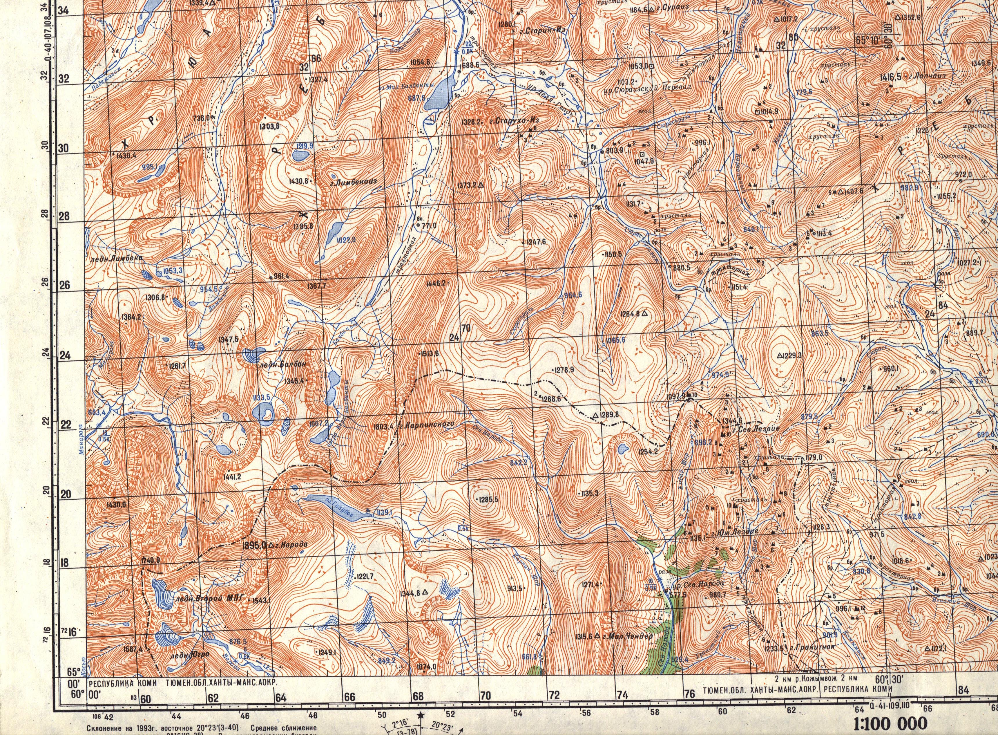
Second summit (the north-west shoulder) of Naroda is the watershed and the highest point of the Komi republic. It is approx 1800-1820 m high. It is such a whim of the topoghraphy. You can look at http://natty55555.funpic.org by yourself.

Natty55555 - Sep 15, 2013 2:33 pm - Hasn't voted

the Komi highest point

> Wolfgang Schaub sent the following message:
>
> Dear Natty55555,
>
> thank you for posting. Very nice to learn more about gora Naroda, its name and history.
>
> Still the question is unsolved for me, where EXACTLY is the highest point of the Komi-Republic? Certainly it is NOT the main summit, but somewhere on the north west shoulder. And how high is this point?
>
> Best regards,
You can see the highest point of Komi at the picture natty55555.funpic.org/prip37.jpg . It is on the right - about 500m from the main peak.
What high it is? I don't know exactly but it is higher than mt Karpinskogo 1803.4 m and mt Zashita 1808 m. Probably about 1820 m high.
You can see the Komi border on the map as well - natty55555.funpic.org/map.jpg
I was there and standed on the brink of a precipice. There was a beautiful view from there towards Mount Yanchenko 1740.9 m.

Natty55555 - Sep 15, 2013 4:36 pm - Hasn't voted

the Komi highest point

Being a notorious highpoint collector I cannot omit, of course, the north west shoulder. I measure its height with GPS as 1821 – 1830 m and determine its coordinates with 65° 02.232'N 60° 06.121'O and claim without knowing better that this is the highest point of the Komi Republic. As expected, there is neither a triangulation post, nor a border marker. Towards W and S a face drops almost perpendicularly down into the valleys of the Manaraga – towards Europe – and the Naroda – towards Asia, respectively. At the same time I stand on the continental divide. 15 o'clock.
-------------------------------------------------------------

Dear Wolfgang,
I don't think there is any doubt You were at the highest point of the Komi republic.
If you go along the saddle from the wooden cross in the opposite direction of the main summit, the saddle will smoothly rise a little bit and suddenly drop off into the deep gulf. The edge of the precipice is what the highest point of the Komi Republic is.
There is a glorious view from there. I wish the weather were more clear.
In fact mt Karpinskogo and mt Zashita are slightly lower.

Wolfgang Schaub

Wolfgang Schaub - Sep 16, 2013 1:35 am - Hasn't voted

Re: the Komi highest point

Good to know, that at least on THIS issue somebody knowledgeable is of the same opinion. "you go along the saddle from the wooden cross in the opposite direction of the main summit, the saddle will smoothly rise a little bit and suddenly drop off into the deep gulf. The edge of the precipice is what the highest point of the Komi Republic is." PRECISELY so. Thank you, Natty 55555, for confirming this.

Natty55555 - Sep 15, 2013 5:20 pm - Hasn't voted

arrest

I like this advice: "Don't worry if you are arrested"! :)
---------------------
I like too. :)
Once I was arrested too by two angry men and a fisherman in the forest. They were sent to chase an escaped prisoner and took me for him. Actually they were scared more than I was. I would allegedly cut their heads off as we all had to sleep together in one hunter's hut. Next morning they already smiled at me. As it turned out in fact they didn't want to search for the prisoner and instead of the service catching fish together with their friend - fisherman.
However yet there are lots of prisoner camps in the remote areas. And it can be a bit dangerous. But yet the rivers, the forests and rocky cliffs are also dangerous. And you can feel yourself like a hiding partisan a bit :). Alas! It is Russia. It can't be helped.

gerrit - Mar 10, 2019 4:11 am - Hasn't voted

Atlas

Hi!

Excellent post!

I'm curious of the atlas you mentioned (»Republic Komi with a collection of maps in the scale of 1 : 500,000«). Is this a topographic atlas? What atlas is this? What is the ISBN? I found online a »Атлас почв Республики Коми« (ISBN: 978-5-7934-0315-3), but »почва« is soil, and browsing through a version I downloaded shows almost no maps. I also found »Атлас Республики Коми по климату и гидрологии« but that is about climate.

Thanks, best regards, Gerrit.

Viewing: 1-20 of 20

Parents 

Parents

Parents refers to a larger category under which an object falls. For example, theAconcagua mountain page has the 'Aconcagua Group' and the 'Seven Summits' asparents and is a parent itself to many routes, photos, and Trip Reports.