
-
 9364 Hits
-
 75.81% Score
-
 6 Votes
|
|
Route |
|---|---|
|
|
46.35570°N / 14.53556°E |
|
|
Skiing |
|
|
Spring |
|
|
Most of a day |
|
|
A hard ski tour |
|
|
Rating the Tour (by Hiking Standards)
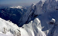
 The steepness of the Roof
The grading system for skiing here.
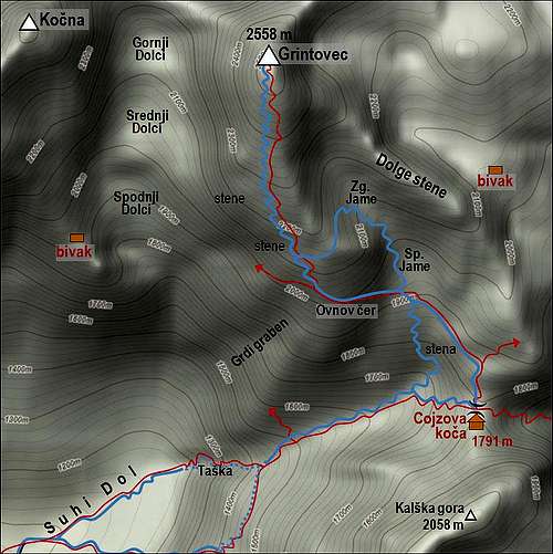
0. General: AD-. From 870 m to 2558 m. Slopes orientation: South. At first cart-road and light woods, then over a 150 m high rocky step by a narrow path, protected with steel cables and pegs. Through dwarf-pine and by a nice opened valley. Then steep grassy slopes to the exposed traverse, which brings you on the roof. Over the 30 degrees steep roof to the top. Overall it is rated as a difficult ski tour. Gear: Normal gear for tour skiing, ice pick, crampons only in hard snow. Milestones of the route: (Kokra valley, 590 m) - Suhadolnik farm, 901 m - above Taška rocky step, 1420 m - End of Suhi dol (valley), 1650 m - start of the Roof, 2000 m - Grintovec, 2558 m.
1. Effort. Cca. 1700 m of altitude, 4 h 30 min.
2. Power. 4 - hard.
3. Psyche. 4 - hard, the passage down from the roof into Jame basin.
4. Orientation. 3 - medium.
Overview
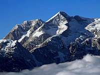
 Grintovec and its Roof
For normal tour skiers Grintovec offers two great downhills. Unfortunately I've never done the classical one from Kamniška Bistrica (1900 meters of altitude!), so I'm describing here the Kokra valley ski tour, which is almost equally often done, and has of course the same upper part.
From Suhadolnik farm, the usual trailhead, it still offers almost 1700 meters of altitude. The upper 1100 meters are in good conditions ideal, especially the roof. A little drawback of this tour is the rocky step of Taška. Usually one takes skis down there. But if there is enough snow sliding carefully down with skis might be even more safe than walking without a proper belaying (if you have no crampons, for example). It all depends on snow conditions - you will see them already on the ascent.
Route Description
Except in a hard winter with a lot of snow, the road to Suhadolnik farm is usually cleaned. But you might need chains, or 4WD to get up there, because a part of the road is allways in shadow, so it might be icy. The parking place is big enough and is some 30 meters below the farm (by the last road curve).
 Above Suhadolnik farm
From Suhadolnik farm you continue up the valley by a good cart-road and later by a good marked path. The forrest road (closed for the public traffic) goes more towards the right (SE) and you will probably use it when skiing down. After some 20 minutes you reach a nice clearing (meadow) and cross it towards the NE. There the road turns sharp left (on the slope of Kočna), so we leave it and continue by the valley in the same direction. The path goes through the woods in the NE direction and soon we reach the crossroads. You have 2 options:
1. While the old path over the rocks of Taška continues in the same direction (NE), the today better marked and maintained (ex hunters) path goes rigt and soon reaches the ravine, coming down from Kalški greben. Here you will often find rests of big avalanches, so you need to decide where to ascend best. The marked path goes by the ravine and over its right slopes (looking up). Where the ravine closes, the path crosses it and enters a steep ridge, fortunately exposed to the sun. In many turns we ascend up, when going around the corner, there are also some protection devices on the path. Those slopes are steep and exposed on some places, so take care! Slightly ascending we reach the more flat part, already above Taška.
2. The old path over Taška ascends its rocks more directly. In summer it is more beautiful, but in winter steep rocks, pegs, cables and even wooden ladders can make you some troubles. If you choose it, you first go by a ravine, approach the rocks, where you can have a short rest in a cave and then start the climb. Pegs and cables lead you shortly towards the left, then up and finally over steep wooden staircase and a narrow, quite exposed path towards the right. Then you go directly up and join the path #1, coming from the right.
Above Taška nice ski terrains begin. First you still need to find a passage through dwarf-pines and across the creek bed (usually a tunnel-like rest of avalanches, then you proceed by a wide and flat enough valley, called Suhi dol. At the end of this valley the normal marked path to the hut continues up (an a bit towards the right, in the eastern direction), but that is a big detour for the summit of Grintovec. It is worth finding a steep passage towards the left, which brings us just below the place, where the traverse on the Roof starts. So, we continue to the end of the valley, ascend there towards the left and then by clearings in the dwarf-pine terrain allways quite steeply (but no danger) up, until we find ourselves on the flat bottom part of Spodnja Jama basin. There the path from the right, from the hut comes.
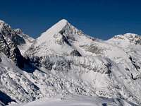
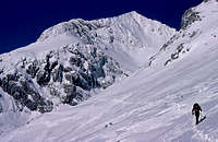
 Kokrsko sedlo from the beginning of the Roof
The traverse (called Ovnov čer) is clearly seen, as everybody ascends over there. You wil usually have good steps, but some care is still needed. In a hard snow you should go here with crampons. Otherwise the traverse is broad enough, but exposed and in a descent not really comfortable for skiing. Above the traverse you find yourself on broad slopes again, and you must decide either to go up with skis or walking. Again: The ascent with skis can be very dangerous as every sliding there might be fatal! Better walk up and have in hands an ice-pick.
 The Roof
As above you there are still some rocks, you need to ascend first a little towards the left, then go up and continue by the roof to the top. You can go over the roof wherever you like, it is very broad and eveny steep. The majority will rush up in the vicinity of the ridge on the right and continue up by it. It depends again on snow conditions. Don't think that reaching the roof you will be immediately on top - you have still 500 meters of altitude to go!
Skiing Down
 A distant view on the upper passage in Jame basin
From the top you obviousely ski down by the roof. When skiing, keep left, so you will not come too close to the walls, in which the roof ends on the right (western side). Approaching the traverse take care again to find the passage. Keep on tracks, don't ski on the right! If you estimate the traverse will be tricky for skiing, you have another, very beautiful option. Traverse above to the left. If deciding so, keep high enough, but even so, you will need to ascend a few meters. But it is worth. On the other side you will find a nice passage into the valley between the Roof and the Dolge stene ridge. Ski freely into the valley, there turn right and ski down (very steep, but not exposed at all) into the basin below (Spodnja Jama). There just continue and you will soon hit your tracks from the ascent. The detour of the traverse is done.
From below Spodnja Jama you ski down in the same direction. Follow your tracks from the ascent. The trick here is, that if you have no tracks, you should not keep too much to the left. Those slopes are fine, but they end with a vertical wall. You should come below that wall from the right side and continue down through a nice couloir in Suhi dol. The joy of skiing down the Suhi dol is unsurpassable. Finally the nice valley ends and you need to find the passage across the valley. Find tracks!
Skiing down the Taška rocks is usually not possible. Carefully walk down and use appropriate gear! Only in very good conditions and for very good and reliable skiers parts of the route over Taška can be done with skis. This is already alpinistic skiing. If doing so, take care not to catch pegs and cables with skis! From below Taška everything is easy. You ski down through light woods and later by the road.