
-
 6214 Hits
-
 86.85% Score
-
 23 Votes
|
|
Mountain/Rock |
|---|---|
|
|
46.53407°N / 11.08559°E |
|
|
Hiking |
|
|
Summer, Fall |
|
|
7986 ft / 2434 m |
|
|
Overview
 Laugenspitze mirrored in Laugensee Laugenspitze mirrored in Laugensee |
The Ortler / Ortles Group is one of the largest ranges of the eastern Alps. It comes in second after Hohe Tauern and divides into 10 subgroups. Strangely enough - unlike any other alpine range of that proportion - its boundaries differ. While on three of its sides it is bounded by very profound valleys in the east it stops about 10km from the wide and deep Etsch / Adige Valley on a murky saddle called Hofmahdjoch. The mountains beyond belong to the equally shady (seak: unknown) Nonsberg Group with its highest mountain: Laugenspitze / Monte Luco. The reason is geological: one of the most important fault lines of the eastern hemmisphere runs across Hofmahdjoch - the Peradriatic Fault, which separates the North-African tectonic plate from the European one. Geologically the Ortler / Ortles Group belongs to Europe while Laugenspitze / Monte Luco belongs to Africa (together with the rest of Italy of course).
Laugenspitze / Monte Luco (also sometimes Monte Lucco) is a small group in itself. Located between two road passes - Gampenpass / Passo Palade and Hofmahdjoch - it consists of about half a dozen summits. The most important ones are called Große, Mittlere and Kleine Laugenspitze (big, medium small) and form a three-angled cirque in which a wonderful small lake can be found: Laugensee. While there are only two reasonable trailheads (at the aformentioned road passes) a multitude of hiking trails lead to the highest of the summits, making use of the slightly confusing terrain. In the end they all recombine on one of three ridges, which directly head up to the summit. Of these the most popular one is the extremely steep south-east ridge at the base of which all trails from Gampenpass / Passo Palade join.
 |  |  |
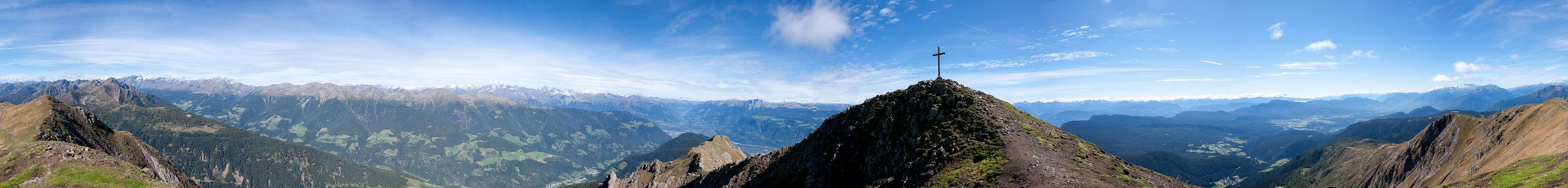
Thanks to its solitary location, Laugenspitze is a wonderful lookout peak, offering views of the Ortler Group in the west, the Ötztal Alps in the north and the Sarntal Alps in the north-east. FFarther in the distance you can see the Dolomites in the west as well as the Brenta-, Presanella-, and Adamello-Groups in the south. Consequently - and also thanks to the short access from the two passes, on a fine day you will find hoards of people trying to climb the mountain. Due to the steepness of the routes many have to turn around making Laugenalm one of the best visited mountain huts / restaurants I have ever seen.
 |  |  |
Side Note: Laugenspitze is located on the language border between the German speaking South Tirol and the Italian Trentino. The locals of Ultental / Val d'Ultimo and Deutschnonsberg are fiercely protective of their language and culture, which results in the almost exclusive use of German names on trail signs or maps.
360° Summit Panorama
  |
Getting There
 Laugenspitze and Hasenöhrl
Große Laugenspitze / Monte Luco is located between two road passes in the very east of the Ortler / Ortles Group: Gampenpass / Passo Palade and Hofmahdloch. Both provide comfortable access to the mountain, though the ascent routes tend to be very steep.
- Take Brenner Motorway A22 to the exit Bozen Süd / Bolzano Sud
- Switch to SS38 towards Meran / Merano.
- Take the exit Lana and drive through the town, following signs to Gampenjoch / Passo Palade or Ultental / Val d'Ultimo
- For Gampenjoch / Passo Palade take SP238, which will take you directly to the pass.
- For Hofmahdjoch take the road into Ultental / Val d'Ultimo.
- After St. Pankraz / San Pancrazio take the road to Proveis / Proves. There are parking lots near the highest point of the road, between and after tunnels #3 and #4.
Red Tape
There's no Red Tape in the area.Accommodation
 Laugenspitze behind Mayenburg Castle
- Lana Accommodation
- Ultental / Val d'Ultimo Accommodation
Weather Conditions
Maps & Books
Maps
- Digital Maps
- Regular Maps
- Meran und Umgebung/Merano e dintorni
Kompass Map WK 53
1:50.000
ISBN: 978-3854910596
- Lana-Etschtal/Lana-Val d'Adige
Kompass Map WK 054
1:25.000
ISBN: 978-3854913542
- Lana, Etschtal / Lana Val d'Adige
Tabacco Map 046
1:25.000
- Meran und Umgebung/Merano e dintorni
Books
- Meran, Burggrafenamt, Ultental, Passeiertal
Kompass Guidebook WF951
Franziska Baumann
Kompass Verlag
ISBN: 978-3854913863
- Rund um Meran - Passeiertal, Texelgruppe, Ultental
Henriette Klier
Rother Verlag
ISBN: 978-3763342907
- Digital Maps