
-
 7607 Hits
-
 77.48% Score
-
 8 Votes
|
|
Route |
|---|---|
|
|
47.71490°N / 14.06473°E |
|
|
Hiking |
|
|
Summer, Fall |
|
|
A long day |
|
|
Medium hard walk-up, partially secured and exposed |
|
|
Rating the Route (By Hiking Standards)
The grading system for hiking and scrambling routes is here.
0. General: From 597 m to 251 5m, exposition E, S and W. Till Kuehkar an ordinary, easy marked path, then to Brotfallscharte a steep, rocky slope with some exposed ledges, protected by steel cables. The summit ridge is not hard, but narrow and exposed. Gear: Good shoes and hiking poles. By the Swiss Hiking Scale the route difficulty would be graded T3.
1. Effort: cca 1950 m, 6 h.
2. Power: 2 - Easy.
3. Psyche: 3 - Medium.
4. Orientation: 2 - Easy. Paths No. 201, 260, 262.
Getting There
See the main page of Grosser Priel how to get in Hinterstoder.
Route Description

At Klinser waterfall
From Hinterstoder, parking place at Johannishof, 597 m, we continue by mountain roads (closed for public traffic) and comfortable paths to the beautiful farm, named Polstergut. In the western direction we continue by a good road till the bottom station of material cable way, which supplies Priel Schutzhaus. All crossroads are well marked.
Tip 1: Till here you can use a mountain bike. That will be a true relief on the return!
Tip 2: You can put your backpack on material cable way and continue to Priel Schutzhaus without it!
From the end of the road a good marked path starts ascending towards the valley step. The surrounding is not the most beautiful here, but we soon reach the Klinser waterfall, where the path turns left and steeply ascends over the rocky valley step. Once above the waterfall we expect the valley to become more flat, but we are not yet there. The slopes are still steep and rugged, the path crosses once again towards the right and before us is the final ascent to the hut through the woods. On Maerchenwiese (Fairy Tale Meadow) a beautiful view on Spitzmauer opens! Some last 30 minutes of hut ascent leads us across the forrest slopes. From the parking place to the hut we need some 2 h 30 min, from Polstergut some 2 hours.

Above the hut
From Priel Schutzhaus, 1422 m, we continue ascending over the meadows and through pine-bushes towards the NW. Slowly the direction turns towards the west and after some 15 minutes we reach the first crossroads. Towards the left a path on Klinserscharte and further up on Spitzmauer deters. For Grosser Priel we continue in the same direction and a few meters higher the second crossroads comes. A signpost directs us right on the SE ridge ferrata, but we continue towards the west. The path No. 260 crosses a ravine and starts ascending by a grassy and scree rib towards the southern ridge of Brotfall. We are already long time in the open terrain. The path slowly turns towards the NW and N and in many switchbacks gains altitude. So, we enter Kuehkar, a boad high basin between Priel S ridge and Brotfall.

Kuehkar
Over a steeper part we ascent over the 2000 meters line, reach a flat upper part of the valley and turn slightly left. Over the slopes of Brotfall we approach the place, where the passage over the walls is the easiest. Marks direct us up and soon we grip the first steel ropes. The ferrata over the ledges is easy, we need to overcome some 250 meters. This passage can require a lot of care when under snow, because steel ropes are not contingent.
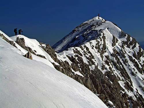
On Brotfallscharte, some 2300 m, a broad western horizon opens. We turn right and ascend by broad, only moderately steep shoulder towards the north. On some 2440 m from the left the path No. 262 joins us, coming from Fleischbanksattel. After a few minutes we reach the Grosser Priel fore-summit.
The last part of the ascent will take us only some 15 minutes, but if slopes are covered with snow or ice, much more. The summit ridge is not hard, but is narrow and exposed. From Priel Schutzhaus to the top we need some 3 hours.
Show a bigger map