Intro
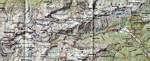
![Hochschwab map]() Hochschwab map
Hochschwab mapThe weather forecast had promised a quite nice weather for the next three days and so we decided for a small round hiking in the eastern part of
Hochschwab Mountains. Our main aims were: the highest point with the same name as the whole massif -
Hochschwab and crossing of the far stretching flat ridge between the summit of
Hochschwab and eastern part of the massif called
Aflenzer Staritzen. The massif of
Hochschwab belongs to eastern part of the North Limestone Alps. I was very captivated by the beauty of the picturesque alpine meadows which were suddenly broken by the jagged vertical limestone walls and karst holes. This part of
Hochschwab Mountains is really worth seeing.
Day 1
![Hochschwab]() Seetal valley
Seetal valley | ![Hochschwab]() Untere Dullwitz valley
Untere Dullwitz valley | ![Hochschwab]() Voisthaler hut
Voisthaler hut |
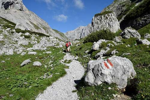
We started our hiking at a car park in the saddle
Seebergsattel above the village
Seewiesen at an altitude 1246 meters. Our first steps leaded down to the village
Seewiesen. It had rained two hours before our arrival and the marked path through the wood was a bit muddy. In the village
Seewiesen we went over to the
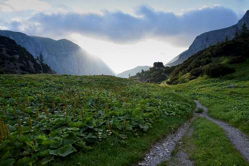
Seetal valley and took the broad marked path to the
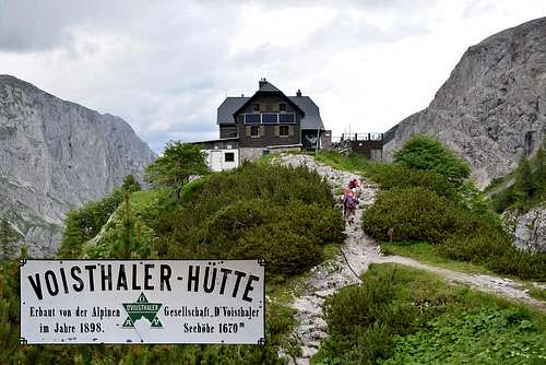
Voisthaler hut. There was an another possibility of the car parking along the forest road at the beginning of the
Seetal valley.
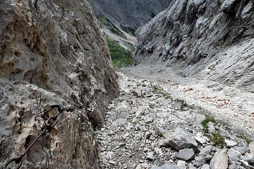
The marked path number 801 or 805 gradually ascends through the Seetal valley, pass the Florl hut (1248 m) and Franzosenkreuz to the Voisthaler hut. Only the last part of the route directly below the hut is a bit steeper. It takes about 3:30 hours from the saddle Seebergsattel to the Voisthaler hut. The whole route through the Seetal valley leads between the majestic jagged limestone walls.
The Voisthaler hut lies at an altitude 1654 meters and belongs to Austria Alpine Club. We spent there a very pleasant evening and the first night.
Day 2
![Hochschwab]() Obere Dullwitz valley
Obere Dullwitz valley | ![Hochschwab]() Obere Dullwitz valley
Obere Dullwitz valley | ![Hochschwab]() G'hackte route
G'hackte route |
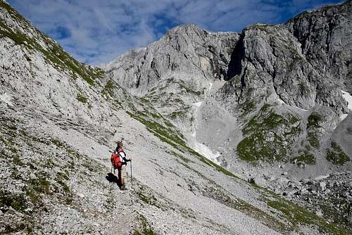
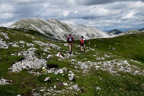
We woke up to the nice sunny morning. After a small breakfest we took the marked path No.851 towards the saddle
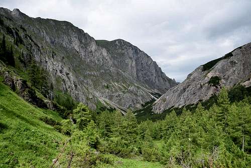
Trawiessattel. The marked path leads through the narrow valley called
Obere Dullwitz. We were surrounded by almost white limestone rock walls and we could see the huge south face of the summit of
Hochschwab straight ahead in the distance. The
Obere Dullwitz valley was full of marmots, chamoises and ibexes. They were calmly grazing on the grassy slopes on the both sides of the path. The first chamoises we met close to the
Voisthaler hut.
After about one hour we reached the Trawiessattel saddle. We were almost standing on the foot of the south face of Hochschwab summit and we attentively were observing the rope team in the face. They had perfect weather conditions for climbing.
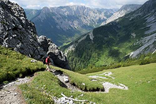
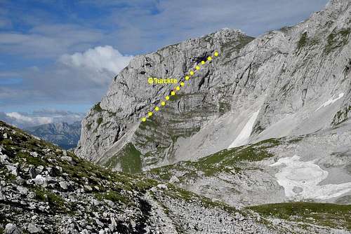
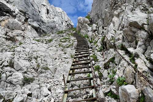
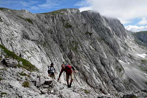
We went on to the trailhead of the G’hackte route, where is the spring of drinkable water called G’hacktbrunn. The G’hackte route is very easy old via ferrata route (rated by A/B by the Austrina scale). The route overcomes the south face of Hochschwab summit in the weakness point on the left side of the face. The route leads through the steep rising rock rift below the summit of G’hacktkogel and is well protected by steel steps, rungs, cables and chains.
![Hochschwab]() G'hackte route
G'hackte route | ![Hochschwab]() G'hackte route
G'hackte route | ![Hochschwab]() G'hackte route
G'hackte route |
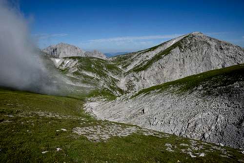
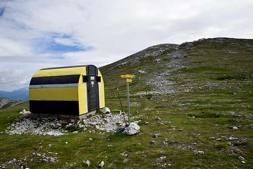
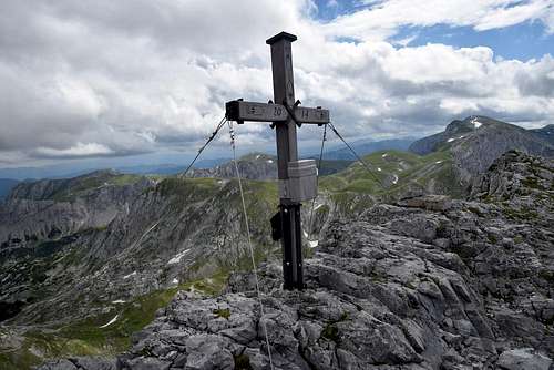
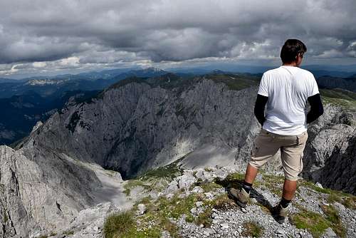
From the end of the G’hackte route we ascended 10 minutes to bivouac called Fleischer-Biwakschachtel, from here is the Hochschwab summit within reach. And really, we reached the big summit cross in other 30 minutes. The Hochschwab summit (2277 m) offered a wonderful view to the all sides. The most gorgeous was the view to the valley below its south face. It took about 3 hours from the Voisthaler hut to the Hochschwab summit.
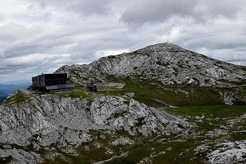
After the short respite we descended across the steep scree north slope to the Schiestl hut. The Schiestl hut with its large patio was very suitable place for our lunch. The Schiestl hut was completely newly built on the place of the old Schiestl hut in 1996 and it‘s a modern environment-friendly hut with minimal consumption of energies.
![Hochschwab]() Fleischer Bivouac
Fleischer Bivouac | ![Hochschwab]() Schiestl hut
Schiestl hut | ![Hochschwab]() A marked path to Ringkamp
A marked path to Ringkamp |
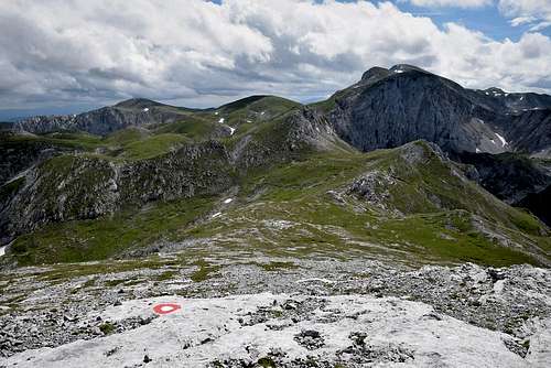
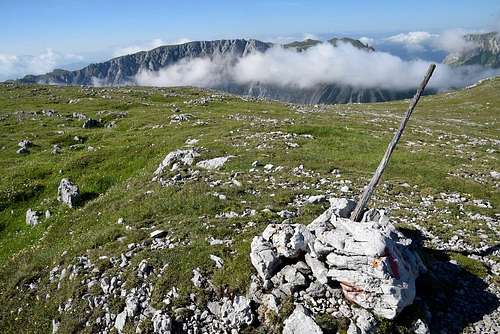
After a good lunch we went on towards the summit of Ringkamp. We passed the turning on the right – the route called Graf Meran Steig – and then we reached the next crossroad in the saddle above the basin Ochsenreichkar (1994 m). We took left and then we started to ascend a steep west slope of Ringkamp. The route was rarely marked, but we couldn’t get lost – still straight up. On the top of Ringkamp (2153 m) we found a small iron summit cross. The essential difference between the Hochschwab summit and the Ringkamp summit was the amount of people: the summit of Hochschwab was crowded of hikers but we spent marvelous lonely two hours of rest on the summit of Ringkamp enjoying a wonderful panorama of the Hochschwab Mountains. Particularly gorgeous we found the view to the immense karst kettle called Oberer Ring which bottom lied about 600 meters directly below us – below the almost vertical eastern face of Ringkamp. The top of Ringkamp is the highest point of the karst kettle.
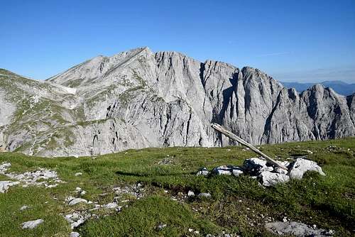
![Hochschwab]() The massif of Hochschwab
The massif of Hochschwab | ![Hochschwab]() The summit cross of Ringkamp
The summit cross of Ringkamp | ![Hochschwab]() The karst kettle Oberer Ring
The karst kettle Oberer Ring |
Then we descended to the saddle above the basin Ochsenreichkar and took the route No. 853 to the bottom of Ochsenreichkar, turned on the right and took the Jaegermayer path (No. 850) to the Voisthaler hut. We reached the Voisthaler hut together with sunset. There were more tourists then the previous day because of nice weather but we spent a very pleasant evening and the second night again.
Day 3
The third day we left the
Voisthaler hut early at the crack of dawn. The latest weather forecast for
Hochschwab massif wasn’t too friendly with us. There was a strong probability of storms after midday and we had at least six hours of hiking on the ridge before us.
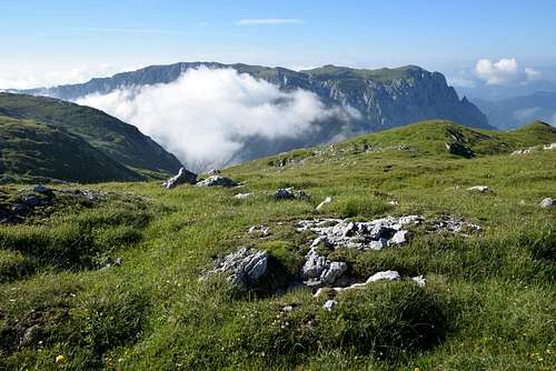
We used the Jaegermayer path (No. 850) to ascend to the ridge. It started only 5 minutes from the hut and finished in the basin Ochsenreichkar below the steep south slopes of Ringkamp where is the only spring of drinkable water in this part of Hochschwab massif. The Jaegermayer path is winding through the small karst basins and holes up and down. We could see a fantastic scenery which was created by sunrise, white limestone rocks and clouds.
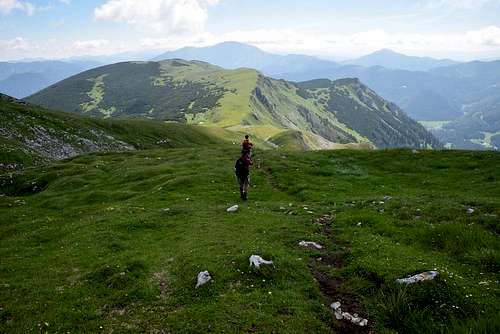
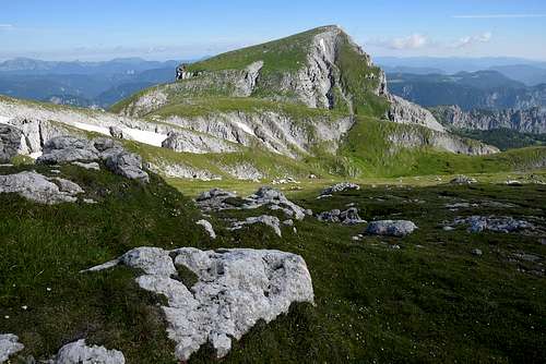
We took up our bottles in Ochsenreichkar and went on upward to the flat main ridge. We went in the shade so far and we met the first sunrays when we were on the karst plateau of the flat ridge. Before our eyes the further path wound among the grassy hills and karst holes. There was the immense karst kettle called Oberer Ring on the left and we were again standing on the edge and marveling to the gigantic pit, deep about 500 meters.
![Hochschwab]() The summit of Ringkamp
The summit of Ringkamp | ![Hochschwab]() The massif of Hochschwab
The massif of Hochschwab | ![Hochschwab]() On the ridge of Hochschwab
On the ridge of Hochschwab |
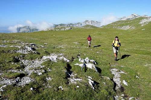
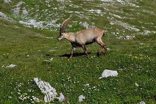
The marked path No.853 crosses the main ridge towards to Aflenzer Staritzen and we went on - up and down, right and left - among the grassy hills and karst holes. We more and more often met lonely chamoises and ibexes. They checked us from respectful distance. But on the large alpine meadow below the summit of Severinkogel next to the marked path we met a great group of about 30 ibexes. We were very surprised to see ibexes in such a big amount and nearness of us. I have visited a lot of places in the Alps and I have never seen so many of them before. Really gorgeous!
![Hochschwab]() One of the omnipresent ibexes
One of the omnipresent ibexes | ![Hochschwab]() The massif of Hochschwab
The massif of Hochschwab | ![Hochschwab]() Hohe Weichsel
Hohe Weichsel |
We went on to the saddle Niedere Scharte. There is a crossroad with turning on the left to the summit of Hohe Weichsel with its majestic eastern face but we went straight to the saddle Seebergsattel.
The landscape around us started to change – limestone rock and stones disappeared and there were only grassy hills and meadows around us. This was the last part of that route – a place called Aflenzer Staritzen. We turned to the right (No.855) and descended the last and very uncomfortable ragged section of the route to the saddle Seebergsattel.
At last after about six hours we reached our car in the saddle – tired but satisfied.


Comments
Post a Comment