
|
|
Area/Range |
|---|---|
|
|
50.06111°N / 17.23206°E |
|
|
Hiking, Skiing |
|
|
Spring, Summer, Fall, Winter |
|
|
4892 ft / 1491 m |
|
|
Overview
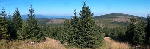
Hrubý Jeseník (High Jesenik), which is called Hohes Gesenke or Altvatergebirge by Germans and Wysoki Jesionik by Poles, is the highest mountain range in the Eastern Sudetes/Jeseníky. It lies in the territory of the Czech Republic, namely in the north of Moravia, between the Rychlebské Mountains to the northwest, Zlatohorská vrchovina/Góry Opawskie (Zlaté Hory Highlands/Opava Mountains) to the northeast, Nízký Jeseník (Low Jesenik) to the southeast and Hanušovická vrchovina (Hanušovice Highlands) to the southwest. The roughly Y-shaped area (530 sq. km) of Hrubý Jeseník is made up of three mountain groups:
- Pradědská hornatina (Praděd Group) in the south
- Keprnická hornatina (Keprnik Group) in the northwest
- Medvědská hornatina (Medvědí vrch Group) in the northeast
 |
Hrubý Jeseník is composed mostly of ancient gneisses and schists with admixtures of quartzite, marble and other rocks. The sides of its massifs can be very steep whereas the crests are broad and rather flat. The highest summits rise a little above timberline. In a few places there are faint traces of small Pleistocene glaciers, the most distinct of them being the corries on the eastern side of Vysoká hole (Velká kotlina/Velký kotel) and Červená hora (Sněžná kotlina).
The table below features Hrubý Jeseník summits that have both an elevation of over 1200 m and a prominence of at least 100 m.
| Summit | Mountain group | Photo | Elevation in meters | Prominence in meters |
 |
||||
 |
||||
 |
||||
 |
||||
 |
||||
 |
||||
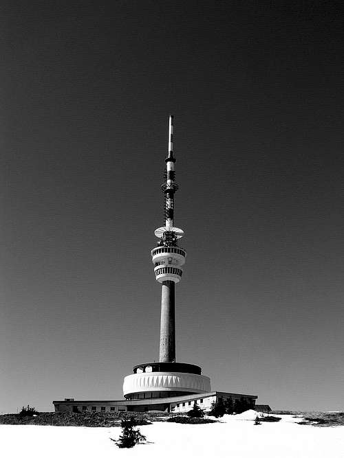
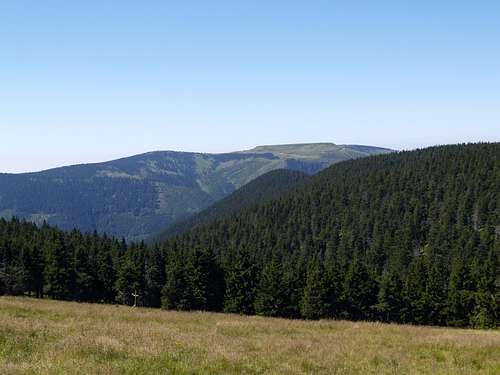
The main ridge of the High Jeseník forms the backbone of the Praděd and Keprník groups. Its south end is the saddle of Skřítek at 874 m, from which it runs north-northeast to Vysoká hole, the second highest summit in these mountains. Before Vysoká hole, at the summit of Velký Máj, the huge lateral ridge of Mravenečník branches off the main ridge to extend to the northwest. Its very top, Dlouhé stráně, contains the upper reservoir of a pumped-storage hydroelectric plant (please see chapter 6). To the north of the summit of Vysoká hole, its secondary summit, Petrovy kameny (1446 m), is topped with an interesting group of rocks. Just over two kilometers north of the summit of Vysoká hole is the highest summit of Hrubý Jeseník, Praděd, with a modern, 162 m tall communications (and observation) tower. From Praděd the main ridge runs north-northwest to Malý Děd, where it takes a turn west-northwest towards the pass dividing the Praděd Group from the Keprník Group. The pass, Červenohorské sedlo, has an elevation of 1013 m and takes its name from nearby Červená hora (Red Mountain) in the Keprník Group.
 Mravenečník Mravenečník |
 Petrovy kameny Petrovy kameny |
 Main ridge NW of Praděd Main ridge NW of Praděd |
From Červenohorské sedlo the main ridge stretches generally north-northwest to Červená hora, then Keprník and finally Šerák at 1351 m. Between Červená hora and Keprník, the spur of Vozka sticks out to the southwest. The summit of Vozka at 1377 m, which sits less than a half-hour walk from the main ridge, boasts one of the most attractive groups of tors in the High Jeseník. The mountain sends off ridges to the west, southwest and south, of which the southwest ridge, running to and past Černá stráň, is the longest and most massive.
 On Červená hora On Červená hora |
 Summit of Vozka Summit of Vozka |
 On NW side of Šerák On NW side of Šerák |
The full traverse of the main ridge of Hrubý Jeseník
Jeseník train station (455 m) - yellow marks - Lipová (480 m) - Javořík (700 m) - Pod Strmým (800 m) - Pod Šerákem (1270 m) - Na Šeráku (1323 m) - blue marks - Pod Keprníkem (1280 m) - red marks - Keprník (1423 m) - Trojmezí (1316 m) - yellow marks - U Vozky (1377 m) - green marks - Vozka (1377 m) - Sedlo pod Vřesovkou (1210 m) - red marks - Vřesová studánka (1250 m) - Bílý sloup (1190 m) - Červenohorské sedlo (1013 m; 22 km from Jeseník, about 7.5 hrs) - Klínovec (1100 m) - Malý Jezerník (1208 m) - Slatě (1299 m) - Švýcárna (1320 m) - Praděd junction (1420 m) - blue marks - Praděd (1492 m) - Praděd junction (1420 m) - red marks - Pod Pradědem - Barborka hut (1320 m) - Ovčárna (1320 m) - Nad Ovčárnou (1380 m) - Vysoká hole (1460 m) - Kamzičník (1420 m) - Nad Malým kotlem (1335 m) - Jelení studánka (1311 m) - green marks - Pecný (1334 m) - Pod Ztracenými kameny (1100 m) - Nad Skřítkem (890 m) - Na Skřítku (874 m) - blue marks - Klepačov (705 m) - Svobodín (740 m) - Pod Smrčinou (630 m) - Sobotín train station (425 m). Length: 57 km. Time: approx. 18 hours
 Orlík (right) seen from Medvědí vrch
 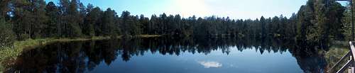 Rejvíz National Nature Reserve
Red Tape and Camping


Hrubý Jeseník, along with adjacent swaths of Hanušovická vrchovina and Zlatohorská vrchovina, is protected as a CHKO, i.e. Chráněná krajinná oblast (Protected Landscape Area), which contains four national nature reserves (národní přírodní rezervace), nineteen nature reserves (přírodní rezervace) and seven nature monuments (přírodní památka).
In a CHKO camping and fires are not permitted except at designated places (of which there are none in Hrubý Jeseník). Bivouacking is not explicitly illegal as long as there are no prohibition signs and you leave no trace. Entry to national nature reserves and nature reserves can be forbidden and if it is allowed you will have to stick to the waymarked trail. For example, you must not approach Petrovy kameny and Velká kotlina can only be seen from the interpretive trail which skirts its bottom.
- Praděd at 820-1491 m, 2031.40 ha; one of the biggest nature reserves in the Czech Republic established through the enlargement and unification of the following six national nature reserves: Petrovy kameny, Velká kotlina, Malá kotlina, Praděd summit, Divoký důl, and Bílá Opava
- Šerák-Keprník at 860-1423 m, 1174.44 ha; the oldest reserve in Moravia, declared in 1903
- Rejvíz at 734-794 m, 329.14 ha; the largest Moravian peat bog, which hosts a pretty big lake
- Rašeliniště Skřítek at 800-890 m, 166.65 ha; peatbog situated just north of Skřítek pass
Maps
Getting There


Accommodation
NB There are plenty of guesthouses and hotels as well as a few campsites around the High Jesenik.- Chata Jiřího na Šeráku at 1323 m, less than 200 m from the summit of Šerák
- On Červenohorské sedlo (1313 m) there are several expensive guesthouses/cheap hotels
- Chata Švýcárna at 1315 m, between Červenohorské sedlo and Praděd
 Chata Jiřího na Šeráku Chata Jiřího na Šeráku |
 Červenohorské sedlo Červenohorské sedlo |
 Švýcárna Švýcárna |
- Chata Barborka at 1320 m, on the south side of Praděd
- Hotel Ovčárna at 1300 m, half a kilometer northeast of the summit of Petrovy kameny
 Barborka Barborka |
 Hotel Ovčárna Hotel Ovčárna |
Man-made Structures on Summits
Praděd
Dlouhé stráně
 |
Mountain Conditions & Rescue

Page History
This page was first created in 2007 as a 'Jeseníky' page and dealt with all of the Eastern Sudetes. Ten years later it was rewritten and converted into a Hrubý Jeseník page, so that it went better with its parent and children pages.
Gorzi - Feb 8, 2012 8:57 am - Hasn't voted
Re: p.s:Thank you guys, I really appreciate that you are taking care of this page.
visentin - Feb 8, 2012 9:16 am - Voted 10/10
Re: p.s:Gorzi, beware, perhaps Jatsek will rename one day your page "mountains of the world" ;)
yatsek - Feb 8, 2012 12:39 pm - Hasn't voted
Re: p.s:The Jeseniky is just a Czech name for the Eastern Sudetes (the author of this page is Czech). You are welcome to create pages for any of the sub-ranges but please don't marry the Hruby Jesenik to the Nizky Jesenik - that'd be another unhappy marriage :)
visentin - Feb 9, 2012 2:46 am - Voted 10/10
Re: p.s:OK, far as you don't merge in it the Carpathians :D