
-
 2678 Hits
-
 0% Score
-
 0 Votes
|
|
Mountain/Rock |
|---|---|
|
|
46.96764°N / 121.85323°W |
|
|
Download GPX » View Route on Map |
|
|
Scrambling |
|
|
Spring, Summer, Fall |
|
|
5560 ft / 1695 m |
|
|
Getting There
Take Washington 165 from Buckley to the Carbon River turn off, which comes up shortly after crossing the Carbon River bridge. This is actually a 'Y,' where the right road goes uphill to Mowich Lake. You should go left here and proceed to the Carbon River entrance of Mt. Rainier National Park.
Overview and route
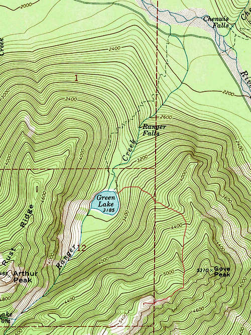
Irish Cabin Peak is the high point of a ridge that extends to the northeast of Tolmie Peak and Ridge in Mount Rainier National Park. It is bounded on the west by the Ranger Creek drainage and Green Lake and on the east by the Ipsut Creek drainage. To its north is the Carbon River Valley and to its south are Tolmie Ridge and Peak. The trailhead described here was accessible by road until periodic flooding from the Carbon River rendered the road unsuitable for continued repair. The driveable part of the road now stops five miles before its previous terminus at the Ipsut Creek Campground.
Park at or near the Ranger Station and walk the old road 3 miles to the Green Lake trailhead on the right. This part can be biked; there is a small bike rack at the trailhead. At one mile the trail to Green Lake passes a detour to Ranger Falls (worth taking) and at 1.8 miles comes to the the outlet of Green lake. From here it is basically a wooded scramble to the ridge on your left (east). This may be easier in early summer/late spring on snow. From just before the lake head generally ESE to about 4000 feet then turn south to find a more north facing ridge, ascending to the left of it to a saddle. Since this route is all forested and there are some cliff bands to avoid, generally the route of least resistance will work best. At the saddle it is easy to turn NE and ascend Gove Peak. Return to the saddle and proceed SW along the ridge to a rocky summit block. A short rock scramble of the east face (class 2-3) takes you to the summit.
Alternatively, one could gain the ridge from the Ipsut Creek trail on the east side. The total elevation gain from where you would likely leave the trail to the summit is about the same as from Green Lake (~2500 feet) but appears steeper. You would have to find a way around or through the more significant cliff bands on the east side. If anyone has taken this route, I would welcome their contribution.
A third potential route is described in Beckey's Cascade Alpine Guide for Gove Peak, which is on the same ridge. This route follows the trail from Mowich Lake to Ipsut Pass. Beckey describes a way trail that takes off from there to the Tolmie Ridge and then to the Irish Cabin Ridge. I did not see such a trail on a recent hike to Tolmie Peak, but if one could find it, I assume it would come out on the east edge of Tolmie Ridge above the cliff bands. From there one would drop down onto the Irish Cabin Ridge and head northeast cross country until reaching the foot of the higher part of the ridge. At that point it looks like a short scramble through trees or on rock to gain the high ridge and from there to its north end and the summit. The advantage of this route is that it begins at a higher altitude, but it includes only two miles on trail compared to five miles on the preferred route (three of which can be biked), though it is probably a mile shorter each way.
iRoute Map
History
A miner named Irish (whether that was his surname or how he was known is up for speculation) built a cabin along the Carbon River in the 1890s. After it passed out of his hands it was known as the Irish Cabin. When the property was bought by the Washington Mountaineers, it became one of their lodges for many years. Members would weekend here or overnight before hikes and climbs. There was an annual Thanksgiving Day picnic for members until one of the periodic floods of the Carbon River rendered it unusable. It was finally dismantled in 1980 but the property is still used by the club for camping and teaching courses. This peak name was submitted to the governing body of the Seattle Mountaineers as a way of commemorating this cabin and was endorsed at their December 1992 meeting, the minutes of which appear in the January 1993 Mountaineers bulletin. For more information on the history of this cabin, see https://www.mountaineers.org/locations-lodges/irish-cabin-property
Other Information
You must pay a $15 entrance fee at the Carbon River Entrance station. The nearest campground is a five mile hike or bike ride on the old Carbon River Road to the Ipsut Creek Campground, two miles past the Green Lake trailhead. A permit is necessary and can be obtained at the Ranger Station. Staying here takes a mile each way off of the Irish Cabin Peak scramble, plus there are other trails to take, such as to the Carbon Glacier or to Tolmie Peak, if you make it a base.