A backpack trip into the remote north-west region of Glacier National Park to climb Thunderbird Mountain, with a base-camp at the 'most spectacular backcountry site' in the park
Several clarifications are provided to the description of the route given in a popular guide book
Michael Kanouff, Greg Evans and Paul Spence
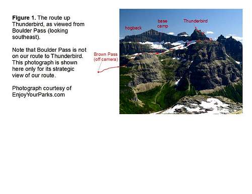
We have been hiking and climbing in Glacier National Park on an annual basis for over 20 years. Most of that time has been spent on the eastern side of the park, in the Two Medicine, Logan Pass and Many Glacier areas. But having explored those areas pretty thoroughly now, we changed things up this year by going to the northwest part of the park, a remote region accessible with a car only by dirt roads, 40 miles from Columbia Falls. The region is just as spectacular as the east side of the park, but tends to have fewer people, and longer approaches to the mountain climbs. So, in late July of 2016 we set off on a four day/three night backpack trip to climb Thunderbird Mountain. The route includes trail and off-trail hiking, bush whacking, a stunning base camp perched on top of a ridge, a steep snow crossing, and class 3 climbing. Much of the off trail portion can be seen in Figure 1. The route is described in a popular guide book by Edwards (A Climbers Guide to Glacier National Park, J Gordon Edwards, Mountain Press Publishing Co., Missoula, MT, 1984), and we recommend consulting that, but there are a few places in that description where some clarifications are helpful, which are described below.
![Thunderbird Mountain]() Route description
Route description
The first step to climb Thunderbird is to get to Brown Pass (6400 ft). This can be done starting either at Bowman Lake or at Waterton Lake. The Waterton approach has the advantage of a shorter distance (8 miles) to the pass if the park boat is taken to Goathaunt, but the disadvantages of having to cross the border into Canada (passport required), and yielding to the boat schedule set by the Waterton Park officials. The Bowman Lake approach is entirely in the US, but results in more trail miles (15) to the pass. We started at the foot of Bowman Lake, and hiked the seven miles of trail to the back-country campground at the head of that lake. We wanted to push further and stay that first night at the Brown Pass campground to make the second day easier, but it was full. As it turned out, that was a good thing, because the mosquitoes at Brown pass were ferocious, while at Bowman Lake they were only a minor problem. Furthermore, the campground at the head of Bowman Lake is pretty nice because it is right on the lake with good views of Thunderbird and Rainbow Mountain.
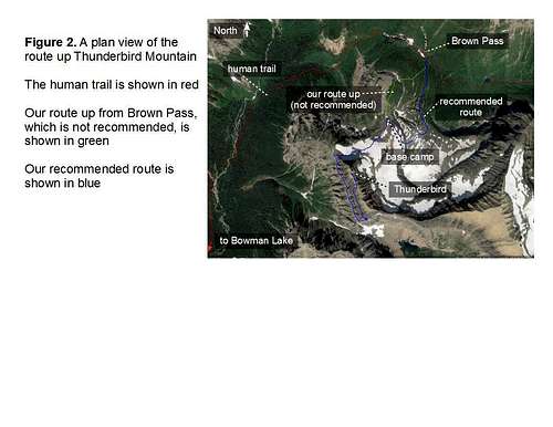
The second day we started out by hiking eight miles with 2000 ft of climb to get to Brown Pass. The trail weaves its way up through a deep valley between steep mountains adorned with waterfalls, including one from Hole-in-the-Wall, a popular back-country campground. The route beyond the pass is all off-trail. At this point Edwards says to 'make an ascending traverse around the east side of the large prominent hump north of Thunderbird Glacier..'. Edwards also refers to the hump as the hogback. This description was either way too vague or just plain wrong. It led us to follow the green route between the pass and base camp, as shown in Figure 2. That route is very steep, loose, loaded with brush and includes a couple of cliff bands. Although we made it up that route, it would have been very difficult to come down it on the return trip as it would have meant a lot of slipping and falling. Fortunately, there is an alternate route that is much better. It is shown in blue in Fig. 2 between the pass and our base camp, which we found on the return trip. So, a better description of the route up is as follows. Leave the trail at the pass and head south through a short section of brush and ascend a small band of cliffs. Enter the broad basin east of the hogback, staying well clear of the steep slopes and cliffs to the west. When southeast of the hogback, turn southwest towards a break in the cliffs, as shown in the figure. Climb up there and continue northwest to the saddle between the hogback and the main mass of Thunderbird, 1000 ft above the pass.
![Thunderbird and vicinity]() Plan view of route
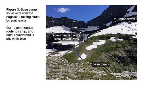
Plan view of routeThis is where we made our base camp, as shown in Figure 3, partly because we were tired after climbing up 3000 ft from Bowman Lake, including the strenuous off-trail ascent up the spine of the hogback, but also because it was a 'spectacular' location in terms of views. Edwards says to continue on from the saddle, cross the Thunderbird Glacier, cross the west face of Thunderbird to its southwest ridge, and make camp there, which he says 'proves to be one of the most spectacular campsites in the entire park', although he warns that there is no water at that location. But we found out the next (3rd) day, when we got to that point on our climb up Thunderbird, that there was no room for a camp there. Meanwhile, the hogback/Thunderbird saddle is a great campsite in its own right with many of the same views as those from the southwest ridge of Thunderbird. As an added bonus, there was a spring near our camp that provided a good flow of water. So, if Edwards thought that the southwest ridge of Thunderbird was the most spectacular site in the park, then surely the hogback/Thunderbird saddle is at least as good because it has the terrain to actually accommodate a camp.
![Base camp]() Base camp
Base camp
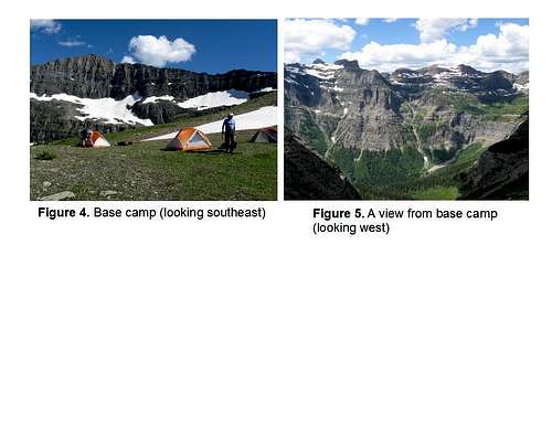
Figure 4 shows our camp, where we spent two nights. There are views in all directions from this camp. The view to the west is shown in Figure 5.
![Views from base camp]() Views from base camp
Views from base camp
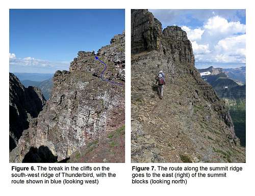
Starting from base camp on our third day, we climbed Thunderbird, following the description given by Edwards. The route can be seen in both Figures 1 and 2. We angled up to the northwest ridge coming off Thunderbird. Along the way Thunderbird Glacier must be traversed, and we had ice axes for that, as recommended by Edwards. There is a game trail crossing the west face of Thunderbird, but it is 30 ft below the northwest ridge, as Edwards points out. Where we came out on the ridge there were some cliffs blocking our descent to the game trail, but by going northwest a short distance on the ridge a break in those cliffs can be found. The game trail itself is not well defined in places, where the traverse is more like side-hilling, that is, loose footing and lots of slipping out to the side. On the far side of the game trail is the southwest ridge. At that point Edwards says, 'Not far east of the ridge see the third prominent couloir that leads up to a break in the southwest ridge. Pass around that ridge above the couloir and onto the upper west face of Thunderbird.'. But when we tried to follow that description we ended up making a rather exposed class 4 move which we later found to be unnecessary. Instead, we would say to continue on the game trail eastward from the southwest ridge past two prominent couloirs. Before reaching the third couloir, leave the game trail and climb upwards, making a number of short switchbacks along the way as necessary, until a turn back towards the southwest ridge of Thunderbird can be made, which leads up to the break in the cliffs on that ridge, as seen in Figure 6.
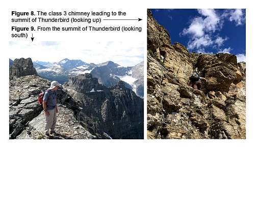
Once on the upper west face of the Thunderbird, as Edwards says, 'it is a gradual climb up easy ledges towards the far north end of the summit. At last the summit ridge is reached...'. But we found it necessary to leave the easy ledges when below the mid-point on the summit ridge, and then climb up rather steeply to reach it. Heading north on the summit ridge Edwards says to go to the east side of the summit blocks, as shown in Figure 7. On the east side of the summit blocks is a class 3 chimney, as shown in Figure 8, which leads to the summit (8800 ft).
![Route through upper cliffs]() Route through upper cliffs
Route through upper cliffs
The climb up Thunderbird was short from our base camp (2.5 miles one-way with 1400 ft of climb), but still intriguing. If the Thunderbird Glacier is included as part of the climb, then it involves all four sides of the mountain. It starts on the north side followed by the west, then the south, back to the west again, then the east side before reaching the top, making it a full tour of the mountain. If the proper route is followed it never exceeds class 3, but there is still sufficient exposure to provide dramatic photo opportunities. And of course, the views from the top are impressive, as shown in Figure 9, as an example.
![Final chimney below summit and summit view]() Final chimney below summit and summit view
Final chimney below summit and summit view
While on the way back down we could see and hear an afternoon thunder shower rolling in from the west. So, we hastened our descent and made it back to base camp by early afternoon. Not long after that it began to hail with thunder and lightning. We all got into our tents to wait it out. The storm was very intense for an hour or two. The hail was coming down so hard it appeared it might rip our tents to shreds. The lightning did not appear to ever strike the ground, at least not near us, but it could be seen directly overhead right through the tent fabric, and it came frequently. It was close too, as emphasized by the mere one or two second delay of the deafening thunder that followed each bolt. It was like something out of a movie depicting judgment day. Perhaps this is how Thunderbird Mountain got its name. While in the middle of that storm, one of our party thought about running down from camp to lower elevations out of fear of the lightning. Fortunately, that was not necessary. Calm and dry conditions returned after a couple of hours when the storm moved beyond us.
The next (4th) day we hiked all the way out to our car at the foot of Bowman Lake, a distance of about 17 miles. It was all down hill though, so we made it back by mid-afternoon. To complete the trip we drove the six miles down to Polebridge for drink and dinner.

Comments
Post a Comment