
-
 8502 Hits
-
 85.87% Score
-
 21 Votes
|
|
Mountain/Rock |
|---|---|
|
|
47.97856°N / 114.33901°W |
|
|
Flathead |
|
|
Hiking |
|
|
Spring, Summer, Fall, Winter |
|
|
6123 ft / 1866 m |
|
|
Overview:
 Snowshoeing on Kerr Mountain in the Salish Range
 Kerr Mountain
Layout designed for best viewing on a "1024 x 768" screen.
Kerr Mountain is a timbered peak that stands above Flathead Lake. The southwestern side of the peak has a series of rocky cliffs that are up to 60 feet in height that would present a great day of scrambling. This route described on this page is considered a class 1 or 2 climb as described below.
There certainly are more difficult and creative ways to climb through the southwestern cliffs but the route described below has no cliffs and no trail after leaving the roads. To reach these cliffs continue along the road after the second junction instead of climbing the northwest ridge or circumnavigate the mountain by walking along FSR #5228 to the end of the road directly below the summit, some maps show a trail climbing towards the summit from there.
Kerr Mountain is located in the Salish Mountains of northwestern Montana. It is easy to identify from the Flathead Valley, as it is the next largest peak to the east of Blacktail Mountain.
This whole area commonly called “Blacktail Mountain” actually has a network of ridges and peaks that form this area. There is a peak known as “Blacktail Mountain” in the area as well but for ease of terminology in this report when referring to this area I will use “Blacktail Mountain Area” which means the greater area around Blacktail Mountain and its surrounding peaks and ridges. When “Blacktail Mountain” is referred t it actually means the mountain called Blacktail Mountain.
Kerr Mountain was the location of a fire camp in 1929, which is an odd place for a fire camp, but maybe there was a fire close by.
A 14 mile Forest Service Road from U.S. Highway 93 in Lakeside, Montana leads all the way to just below the summit.
The Blacktail Mountain Area also boasts some pretty excellent Nordic trails. The North Shore Nordic Club maintains a network of trails that range from easiest to more difficult. The trails are groomed every 3-5 days depending on conditions. This is also an excellent place to snowshoe in the winter/spring season as well as mountain bike in the summer and fall.
There is also a recreational trail being established that will travel from southwest of Kalispell near Foys Lake to Blacktail Mountain. It is called the Foys to Blacktail Trail. There is a group of citizens raising funds to secure easements as well as purchase 340 acres of land, which will be added to a county park called Herron Park. When completed this trail will be about 15 miles one-way. It is currently possible to ride, run or ski to Blacktail Mountain from Herron Park on Forest Service Roads but requires a map and good route finding skills.
Interestingly enough there is a hydroelectric dam at the south end of Flathead Lake named Kerr Dam. It is not known of there is any name association with the mountain and the dam but they do share a name.
Kerr Dam Information:
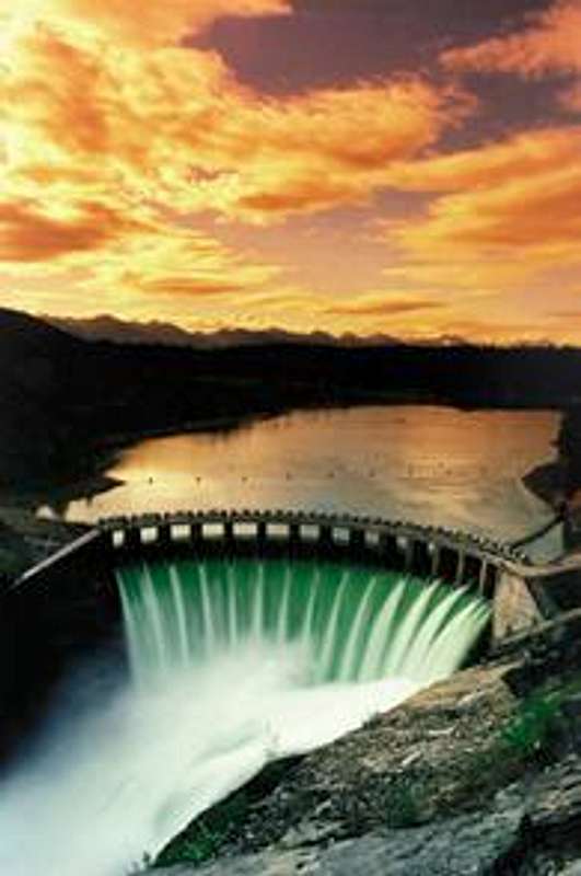 Please do not vote on the image on the left.
 Construction of Kerr Dam began on May 23, 1930, by Rocky Mountain Power. Kerr Dam was named after Frank A. Kerr, who was the president of MPC. On July 1, 1931 the depression caused money and funding to dry up, so construction stalled for five years. In 1936 Montana Power resumed the construction of the dam, and in August 6, 1938 the dam was completed. It consisted of one unit and a powerhouse. All in all it took around three years to construct.
At peak construction 1,200 men were employed. The higher skilled workers earned a couple of dollars an hour, while the lower skilled workers earned around forty to fifty cents an hour. There were no major problems with the dam during construction, but around fourteen deaths occurred among workers who were involved in the construction of the dam.
The dam, which began operation in 1938, is 541 feet long and 205 feet high. Its installation raised the level of Flathead Lake by 10 feet over the natural lake outlet. The dam’s 28-mile-long reservoir has a storage capacity of 1.2 million acre-feet. Kerr Dam is classified as a “storage generation” project because it uses the water stored in its reservoir to generate electricity.
Flathead Lake, which lies in the Flathead Valley of northwest Montana, is the largest natural freshwater lake west of the Mississippi. It drains a major portion of northwestern Montana as well as parts of Canada via the North Fork of the Flathead River. It also holds water from the west side of Glacier National Park. The lake is 28 miles long, up to 15 miles wide and a maximum depth of 370 feet. The lake has many islands and Wild Horse Island, the largest island in the lake, is a wildlife refuge for more than 75 kinds of birds as well as deer, bighorn sheep, coyotes and bear. Geese, ospreys, herons and eagles, among other types of birds, frequent the appropriately named Bird Islands.
The Dam was operated on an annually renewable license between 1980 and 1985. In 1985 the Confederate Salish Kootenai tribes and the utility agreed to a new contract, which was approved by the Federal Energy Regulatory Commission (FERC). To start the new FERC license the new agreement provided for a $ 9 million annual rental fee paid to the tribe from the dam's earnings.
Currently Kerr Dam has three hydroelectric units, which are capable of generating a total capacity of 196 megawatts. (One megawatt can satisfy the average energy needs of 750 households.) The above information is from the PPL Montana web site as well as LakeCountyDirect.
Getting There:
 Some of the scenery
Kerr Mountain is located on the West Shore of Flathead Lake. The trailhead described for access is located at Forest Service Road # 5227 along the Blacktail Mountain Road (FSR # 917).
Getting there is easy.
Access from U.S. Highway 93 is located at the base of a long hill on the south side of Lakeside and is well marked in both directions with signs designating National Forest Access as well as the Blacktail Mountain Ski Area. There is a grocery store surprisingly called Blacktail Grocery at the start of the road.
To reach Forest Service Road (FRS) # 917 drive up FSR #917 for about 10 miles through various switchbacks. After about 4 miles the pavement ends and the graded gravel road is good enough for passenger cars. FSR # 5227 will be on the left side of the road.
Red Tape:
Please refer to the Flathead National Forest web site for the Red Tape under the FAQ.Route Information:
 Route Map
 Shale slopes lead to the summit
This is a simple route with little chance of getting lost. Roads practically surround the peak with the exception of a short section below the rocky southwest side of the peak. Some maps also show a trail from near the end of FSR # 5228, but we did not use this route and the trail may or may not be there.
This route is a little over a mile in length and climbs a mere 770 feet along the northwest ridge as described below.
Follow FSR # 917 from Lakeside to the gate marked FSR #5227. Park where it is convenient and walk along FSR #5227 to the first junction and turn east (left) and then at the next junction take a right. Please see the map for details. Continue along that road until it is convenient to attain the northwest ridge (which has a number of false summits) to the summit.
When to Climb:
 Spring Route through the trees
This climb can be done at any time of the year because the road to Blacktail Ski Area is plowed during the winter. It is possible to drive it in a 2-wheel drive vehicle but a 4-wheel drive may be able to handle the route during the winter.
In the winter plan on using skis or snowshoes and get off the road for better views and great snow. There is a LOT of snow in this area in the winter. The average snowfall is over 250 inches.
If the preference is for no snow plan on a trip to Kerr Mountain anytime between May and the end of October.
Weather:
 Wind and snow ..... perfect day for a climb!
Essential Gear:
A vehicle or mountain bikeSnowshoes or Skis
Water
Camera
Sun screen
Bear Spray
Camping:
You can generally camp anywhere on National Forests, unless the area is posted otherwise. If you need your vehicle to camp, there may be some restrictions on where you can go. You may not drive or camp where you will cause resource damage, such as making vehicle ruts off roadways or damaging trees or streams. We recommend that you camp at least 150 feet from all lakes and streams. The distance you may pull your vehicle off an established roadway will vary, depending on the travel management policies of each forest. Generally, you may not drive more than 300 feet off a roadway to park, but this distance may be less in some areas. Please contact the local office near where you want to go.The nearest campground is a state park called West Shore State Park. For Montana residents entry into the park is included with purchase of their vehicle license plate. Out of state visitors pay $5 for entrance to parks that charge a fee. There also is a camping fee for overnight use. The campsites are available on a first come basis.
External Links:
Visit MontanaFlathead National Forest