
-
 33514 Hits
-
 85.36% Score
-
 20 Votes
|
|
Mountain/Rock |
|---|---|
|
|
40.62520°N / 111.668°W |
|
|
10403 ft / 3171 m |
|
|
Overview
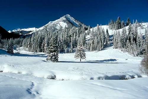
Kessler Peak marks the northern end of the ridge extending north from Mount Superior, which separates Mineral Fork on the west and Mill D South Fork on the east. The summit is centrally located in Big Cottonwood Canyon, and with virtually no nearby obstructions it provides an excellent 360° viewpoint for the canyon, as well as portions of the south Salt Lake valley.
Kessler Peak is located within the Wasatch National Forest, a short distance down the Canyon from the Brighton and Solitude ski resorts.
USGS Quads:
- Mount Aire, Utah (1:24k)
- Dromedary Peak, Utah (1:24k)
![Kessler Peak from Creek]()
Getting There
The two most common routes up Kessler Peak are the North Route and the Carbonate Pass Route. Both routes begin from the Doughnut Falls trailhead in Big Cottonwood Canyon.
From the intersection with Wasatch Boulevard, drive 9.3 miles east up the Big Cottonwood Canyon road (State Highway 190), then turn right (south) onto Cardiff Fork Road. Proceed through a gate and follow the paved/gravel road for 0.75-mile to the trailhead.
See the individual 'Routes' section for details on ascending the peak.
![]()
![]()
![]()
![]()
![]()
Red Tape
No fees or permits are currently required for hiking in this area.
In the early season Cardiff Fork Road may be gated shut where it leaves Big Cottonwood Canyon road. This will require parking at the large pullout area near the gate and walking an additional 0.75-mile each way to/from the standard summer trailhead.
![]()
![]()
![]()
![]()
![]()
When To Climb
Spring through late fall. Winter ascents are possible, but a number of large avalanche paths surround the peak. Carefully assess snow conditions before considering a winter attempt.
Camping
Camping possibilities are abundant throughout Big Cottonwood canyon; however, this is a relatively short hike and can be completed in a half-day or less.
Mountain Conditions
- National Weather Service forecast .
- Utah Avalanche Center website.


gdaly59 - Jul 24, 2019 7:12 am - Hasn't voted
getting there correctionthe driving distance from the intersection of wasatch blvd and big cottonwood canyon rd to the turnoff at cardiff fork rd to the donut falls trailhead is 8.8 miles, not 9.3 miles.