-
 10369 Hits
-
 81.18% Score
-
 13 Votes
|
|
Mountain/Rock |
|---|---|
|
|
49.24142°N / 19.83650°E |
|
|
Hiking |
|
|
6001 ft / 1829 m |
|
|
Overview
Kominiarski Wierch ("Peak of the chimneys", also formerly called Kominami Tylkowymi), is a limestone Peak located in the Polish western Tatras, separating the two valleys ofDolina Chochołowska and Dolina Kościeliska.
Despite its altitude of 1829m, it is a very impressive mountain, perhaps because its complex jagged shape, and its excentred position on the foreground of the northern hillside of the Tatras. Its beauty owes a lot to its limestone karstic geology.
Kominiarski Wierch belong to the same geologic range that links it to Czerwone Wierchy, Giewont, and later on the Belianske Tatry.
The rocky wall that links it to Czerwone Wierchy is nothing else than the famous gate of Dolina Kościeliska, from which this valley takes its name ("steeple's valley").
Since August 1th 1988, the trail which climbs it was closed in order to protect eagles nesting. Even with any kind of guide-licence or other paper stuff, it is strictly forbidden, unfortunately for the hiker.
But we could say, despite this, that Kominiarski Wierch is perhaps one of the most charismatic mountain of the Polish western Tatras.
The trails going the closest to this mountain which give the better taste of this massif are :
- The yellow marked trail going through Iwaniacka Pass, between Kominiarski Wierch and Ornak.
- The blue marked trail going to Polana na Stolach from Dolina Kościeliska. This place is actually the one visiting the most significantly the mountain of Kominiarski Wierch.
The historical trail going to the summit is arduous and was found in 1892 by Karlowicz on the north side. In 1901, a new tourist route was opened Iwaniacka pass.
The mountain stretches overs 4 hectares and counts more than 140 caves, in which used to hide robbers. It hosts 5 pastures: Hala Stoły, Hala Kominy Tylkowe, Hala Kominy Dudowe, Hala Iwanówka, Hala Smytnia, 2 of them accessible by the trails already mentioned.
Getting There
Both valleys Dolina Chochołowska and Dolina Kościeliska are quickly reacheable from Zakopane, 100km south from Krakow, reacheble by bus and train. The entrances of the valleys are also served by bus from the station of Zakopane.
However, if you are by car and you plan to reach Dolina Chochołowska, I recommend another itinerary: From Krakow, drive in the direction of Zakopane until Rabka, then the road that goes through Chocholow.
Both car parks of Chochołowska and Kościeliska cost around 10zl, but if you arrive before 7am you may see no-one.
Red Tape
As told above, Kominiarski Wierch is strictly forbidden. In addition, it is also strictly forbidden to leave the marked trails in the Polish Tatras.However, SP's member Tomek climbed it :) as well as Yatsek in the 80's when the top wasn't closed yet. Here are some summit views:
Routes
Kominiarski Wierch cannot be climbed but a very interesting hike can consist in making a "tour around Kominiarski Wierch".
The hike can be started either from the entrance of the valley Dolina Koscieliska or Dolina Chochołowska; but the first point is perhaps more convenient, considering the shape of the loop.
A third alternative can also be the Dolina Lejowa, half way between them and reaching directly Kominiarska Polana, but the loop will involve more elevation difference.
The interest of this loop can be to visit every interesting site in the surrounding of Kominiarski Wierch.
In Dolina Koscieliska, climb first to Polana na Stolach via the blue trail, to see the traditional barns.
Back in the valley, you can give a visit to the entrance of three famous caves of the surronding. First, Jaskinia Mroźna, via a short black trail.
Then, near the "gate", Jaskinia Raptawicka and Smocza Jama via the two small red and yellow marked trails facing each other.
At the hut Schronisko na Hali Ornak, you can give a visit to a very interesting lake nearby, Smreczyński Staw, surprisingly nestled in the level of the forest, a quite rare case in the Tatras.
Back to the hut, climb via the yellow trail to the pass Iwaniacka Przełęcz, and go down into the valley Dolina Chochołowska.
Walk down the valley Dolina Chochołowska for 20mn until the junction with the black trail going to Kominiarska Polana, and back into Dolina Koscieliska.
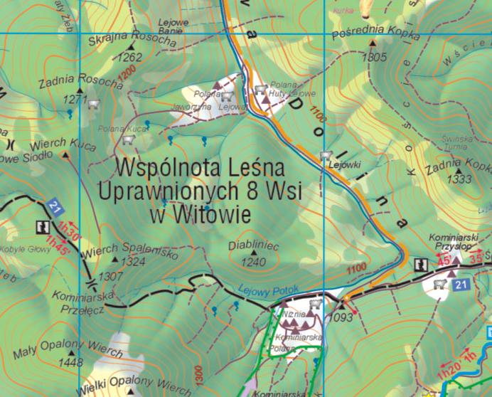
Note: On this old map, you can regognize the old traditional route, now unmarked, leading to the summit :)
Accomodation
* Campings :
Camping is strictly forbidden in both National parks TPN (Poland) and TANAP (Slovakia).
However there is one campsite lead by the PZA (Polish alpine club) near the entrance of Chochołowska valley, and 2 or more campsites in the city of Zakopane.
* Mountain huts :
- Schronisko na Polanie Chochołowskiej (www.chocholowska.zakopane.pl), Dolina Chochołowska, Poland. This is a big hut and generally finding a place is not too hard. Take duvet and mattress anyway during sunny week ends when there is a lot of people.
- Schronisko na Hali Ornak (www.ornak.tatrynet.pl), Dolina Kościeliska, Poland. Very beautiful medium-sized mountain hut in the heart of the valley. Out of the season and big week ends, generally finding a place is not too hard. Take duvet and mattress anyway.
Maps
The excellent online map of Western Tatras on theMapytatr website:

External Links
Kominiarski Wierch on Wikipedia, in Polish (I translated some of the informations in the overview section) :http://pl.wikipedia.org/wiki/Kominiarski_Wierch
English forum on HIKING.SK :
http://hiking.sk/hk/li/forum-english_forum.html
Eric's page about Tatras:
http://h.visentin.free.fr/carpates


