Overview
![Peña el Aguila, La Peñota]() Peña el Aguila and La Peñota seen from the west
Peña el Aguila and La Peñota seen from the west - at least most of it -appears to be one of these typical lower mountain ranges - lots of round-topped, easy summits with an occasional rock on top. But upon a closer look you see lots of areas with impressive granite rock formations,
La Pedriza and
Siete Picos being the best known among them. And at an even closer look you'll see lots of Ianus-faced mountains with one hill-like and one rocky side.
La Peñota is one of these, a low mountain of less than 2000m height on the eastern boandary of
Valle de Fuenfria.
Its regular normal ascent starts in the valley and either heads across neighbouring
Peña el Aguila in the north, a very broad and very long stretched mountain, or through Collado del Rey from the east. Both ascents may be steep in places but are little mor than regular hiking routes. A third route, however, starting at
Puerto de Guadarrama (also
Puerto de León or
Alto del Puerto)first leads across a ridge of two or three minor summits before reachning the
La Peñota west ridge. And here a wonderful 1h ascent starts towards the summit.
The ridge is made up from granite blocks, which forms bizarre structures. The path winds between several minor summits, reaches a narrow ledge, which leads to a small saddle which separates a single tower from the main ridge. Again it threads along ledges to pass the western side summit, passes to the northern side of the ridge and finally heads up to the saddle between west and central summit. There is a lookout (an old civil war position) at the base of the western summit and a summit pillar on the central one. Reaching its top requires a bit of manual work. A third summit, the eastern one is formed like a large mushroom, some 200m to the east of the other two. It can be easily reached by ashort scramble and a couple of jumps towards the platform on top.
La Peñota is a rather solitary mountain as the ascent routes all are rather long. Its standalone position, however, makes it a good lookout towards the other, less central parts of the
Guadarrama Range.
Siete Picos and the southern range between
Cabeza Lijar and
Abanthos are the most prominent ones in the west and south while the
Mujer Muerta south-western parts can be seen in the north.
In all,
La Peñota is worth a trip, maybe along the long ridge traverse around the summits on the rim around
Valle de Fuenfria (see route).
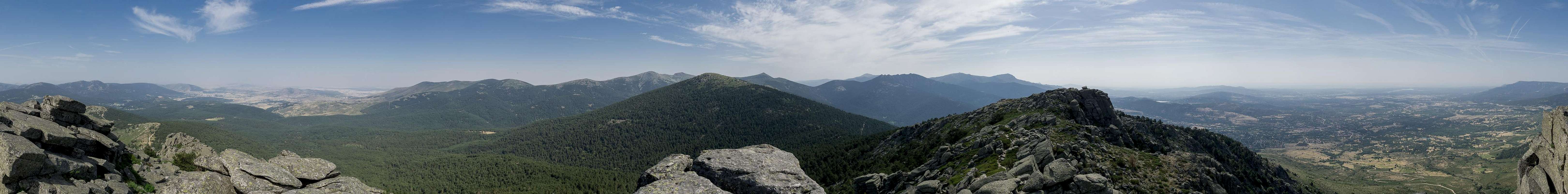
360° Summit Panorama
360° summit panorama from La Peñota |
Getting There
![In the col between western and central summit]() In the col between western and central summit with the eastern summit in the back
In the col between western and central summit with the eastern summit in the back- From Madrid take motorway A-6 / AP-6 to the exit Guadarrama.
- For Valle de Fuenfria take M-614 to Guadarrama
- Switch to N-IV west for a few hundred metres
- Turn right onto M-622 to Cercedilla
- There follow the signs to La Dehesa and Fuenfria
- For Puerto de Guadarrama remain on N-IV which leads directly to the pass.
Red Tape
![Summit Panorama from the eastern summit]() Summit Panorama: Mujer Muerta behind Peña el Ageuila, Peñalara, Siete Picos, La Maliciosa
Summit Panorama: Mujer Muerta behind Peña el Ageuila, Peñalara, Siete Picos, La Maliciosa
I’m not aware of any red tape. In general the parking lot on
Puerto de Guadarrama is reserved for guests of the restaurant but it doesn’t look like this is enforced.
When to Climb
La Peñota can be climbed in all seasons. In winter the most reasonable ascent is the one across
Peña el Aguila from the north with tour skis or snowshoes.
Accommodation
![La Peñota]() La Peñota seen during the approach from Puerto de Guadarrama
La Peñota seen during the approach from Puerto de Guadarrama
There’s lots of accommodation around
Sierra de Guadarrama, especially close to the ski centers. Finding it online is a bit more difficult and you might have to visit commercial sites especially if you don’t speak Spanish.
On the other hand – Madrid is just 50km away so you’ll be able to get all kinds of accommodation within an hour of the trailheads.
Weather Conditions
Maps & Books
Maps
- Sierra de Guadarrama
Mapa excursionista y turistico
Editorial Calecha
1:30000
ISBN: 978-84-943474-2-9
- Guadarrama Parc Natural de Peñalara
Mapa Y Guia Excursionista
Editorial Alpina
1:25000
ISBN: 978-8480901598
- Guadarrama / La Pedriza
Editorial Alpina
1:25000
ISBN: 978-8480-9056-64
Books
My recommendation is a guidebook by Rother Verlag, available only in German. The book is an excellent hiking guide covering all the interesting areas of the range. Since it comes with small maps for each excursion it might even be used without a map to support them. I don’t know the Spanish publications in the list so cannot comment on them
- Sierra de Guadarrama
Jürgen Bogner
Rother Verlag
ISBN 978-3-7633-4362-1
- Guadarrama : 50 excursiones que no te puedes perder
Marta Viladot Santaló
Lectio Ediciones
ISBN: 978-8416012817
- Guadarrama Parque Nacional: 50 excursiones fáciles
Domingo Pliego
Ediciones Desnivel
ISBN: 978-8498292817
- Guadarrama con esquís : 20 itinerarios de esquí de montaña por las sierras de Guadarrama y Ayllón
Enrique Ribas Lasso
Ediciones Desnivel
ISBN: 978-8495760180

 2865 Hits
 75.81% Score
 6 Votes
 Peña el Aguila and La Peñota seen from the west


 In the col between western and central summit with the eastern summit in the back
 Summit Panorama: Mujer Muerta behind Peña el Ageuila, Peñalara, Siete Picos, La Maliciosa
 La Peñota seen during the approach from Puerto de Guadarrama