-
 7654 Hits
-
 0% Score
-
 0 Votes
|
|
Route |
|---|---|
|
|
0.14204°N / 78.28872°W |
|
|
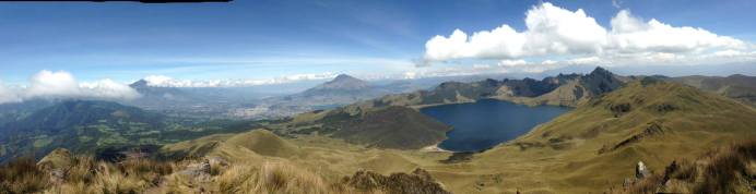
Overview
Getting There:
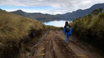
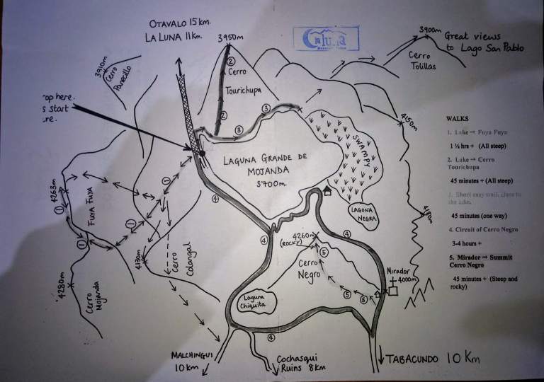
There are two access points for Lagunas de Mojanda where Cerro Nego and Fuya Fuya are located. The more common and reliable access is from Otavalo. The other access is from a smaller town a bit south called Tabacundo. The Tabacundo access road is less trodden and more expensive by taxi. Also taxi will often refuse to go if the road is washed out because of rain.
The Lagunas de Mojanda peaks are some of the least taxing mountains to climb in Ecuador. To get there, take a bus to Otavalo from the Quito terminal of Carcelen. The bus takes about two and a half hours and runs about every 10 to 20 minute. From there take a truck taxi up to Lagunas de Mojanda. The truck will cost $15 one way. My super sweet/awesome taxi drive Edison can be reached at +593 99142991. One alternative to going to Lagunas De Mojanda from Otavalo is staying, the night before, at La Luna. This adorable hostel is located on the road to Lagunas de Mojanda. It costs $4 to get there from Otavalo by taxi or you can take a bus which runs every 40 minutes (ask for the “Mojandita” bus). This but starts running at 6 am and goes until 7 pm except on Sunday when it stops running a 5 pm. The bus can be caught from the Otavalo bus terminal or on the Panamerican Highway and Sucre street. I went to this hostel countless times and always brought visitors. It is scenic and beautiful- an experience in itself. Probably my very favorite place to stay in Ecuador.
Okay so back to getting to Cerro Negro & Fuya Fuya. Marco, our Peace Corps head of Safety and Security would kill me if he knew I was giving this advice but it has always worked for me times so I’m passing it on. After spending the night at La Luna start walking up the road in the morning towards the laguna. As cars pass wave one down and hitch a ride. Although I would recommend against hitchhiking in Ecuador in general, I’ve never had any issues with the road up to Mojanda. You can do the same coming back down, jumping out at the turn off to the hostel. If it makes you feel safer you can usually hitch a ride in the back of a truck which tend to be plentiful. Note that this doesn’t work too well unless its the weekend. Not many people go up to Mojanda during the week.
Fuya Fuya: Distance Round Trip: 2.9 miles Elevation Gain: 1,650 Feet Good Wikiloc Map found here!
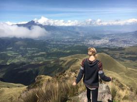
When you arrive to the laguna (after about 40 minutes on a cobbled road), note that Fuya Fuya is the closer mountain and is relatively easy to trail find/summit. Maps.me has helped me times on this trail but there are a few alternative ways up and down it. The Maps.me places the summit between the two Fuya fuya peaks but you would be missing out big time if you did not continue up the main (right peak) for the epic view on a clear day. (There’s not clear trail up the left peak.) Lagunas de Mojanda clouds over quickly in the late morning so get at it as soon as possible although this might be difficult if you’re planning to hitchhike. If you want, taxi driver Edison (+593 99142991) can also take you from La Luna for $12 dollar.
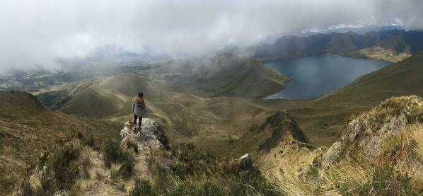
Cerro Negro: Distance Round Trip: 1.2 miles Elevation Gain: about 1,100 feet
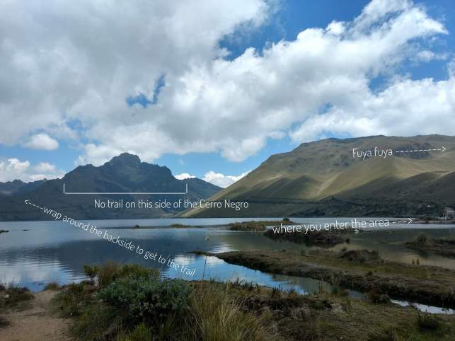
Despite the Summit Post reports that there is a trail up Cerro Negro from the east side, after numerous attempts, I have never found such trail. The standard trail up Cerro Negro is from the opposite side, Behind the lookout. From Fuya Fuya, walk or drive up the road around the main lake staying left at the fork. Follow the road which traces edge of the main laguna and then wraps up the backside of Cerro Negro until you reach the lookout. There you can find a trail to the top. The Maps.me trail is near by and will also work but is more just of a vertical B-line.
The Double Summit: Distance Round Trip: 13.7 miles Elevation Gain: 3,126
Be aware that for much of the year the road to Cerro Negro can be washed out and even when its not, the road is extremely rough. A double summit may be best done on foot, connecting the two mountain. Although not a lot of elevation gain, it is a long distance to connect the two. However if you came up from the Otavalo side, summited Fuya Fuya, walked to Cerro Negro and then summited that, you would be coming down right on the Tabacundo access road. With any luck (and better luck on the weekend) you might hitch hike back down that way, avoiding the long trek back to where you started and cutting your total distance way down.
Camping:
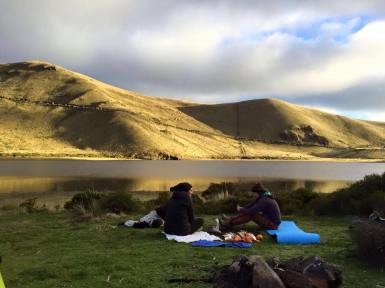
When I camped in Lagunas De Mojanda a park ranger came by and told up we should not be building a fire and shouldn’t be camping. After some conversation though he let as both stay and build our fire. Such is Ecuadorian authority. I don’t let this discourage you from camping there. I’ve had plenty of other friends that have done so and have had no issue. Just keep it in mind that if you do have a run in with authority, stay calm and explain that you didn’t know and you are planning to clean up after yourself/fully extinguish your fire. It is a beautiful place to camp but like any other spot in the Sierra of Ecuador, the nights get cold!
As always… Look good, have fun, be safe. Good Luck!
External Links