What's new?
![Leitenkopf from Ebeneck]() Zellinkopf and Leitenkopf from Ebeneck
Zellinkopf and Leitenkopf from Ebeneck UPDATE MADE:
 15/08/2005 Finale page setup made+more info added
UPDATE MADE: 14/08/2005 Initial page setup
Overview
Geographical Classification: Eastern Alps - Hohe Tauern - Goldberg GROUP - Laitenkopf
Laitenkopf is a mountain that lies in the southern ridge of the Goldberg GROUP. The ridge lies between the valleys of Winklern-Rangersdorf and Winklern-Mörtschach.The mountain has an height of 2449m and offers an exciting view to several mountain groups: Schobergroup, Glocknergroup, Goldberggroup, Kreuzeckgroup, Lienzer Dolomites... When you climb it a path will take you through the wood and at the end a steep climb will bring you to the top. There are 2 crosses on the top. The smallest has been set there only a couple of years ago, in 2001.
How to get there?
From Obervellach: follow direction Winklern, when you pass Rangersdorf there wille be a direction-arrow at the right side of the road with 'Marterle' on it. From there it's 12 km up on the mountain. There you can park your car.
From Winklern: follow direction Obervellach, after 4km you will see the direction-arrow with 'Marterle' on it.
Marterle
Marterle is a church that lies at 1836m. They started building the church in 1902 and it was completely finished in 1903. The church is still visited as a pilgrimage-church. Up on the mountain there are also huts. So sleeping is possible there.
Rangersdorfer Hütte
9833 Rangersdorf Nr. 6
Tel. 0043 4823 455
Climbing route
Climbing starts mostly from Marterle. There is a gate next to the parking of the Rangersdorfer Hütte. You pass that gate and then you have to follow the left path. From there direction-arrows will point the right direction to the top of the Laitenkopf. The first part of the ascent runs through the wood. And after one hour I think you will exit the wood. From there it will take another hour I think to the top. Maybe it can take less time. I forgot to look at my wacth. The last part of the ascent takes you over a steep slope where you have to "scramble" a little bit. It is really not dangerous, even beginners can make it. After reaching the top, enjoy the magnificent view!
Update by Vid Pogachnik: I added the map on the left and a few pictures. Seba, if you find it inappropriate, please update the page again.
From Marterle the following round tour is very popular: Marterle - Ebeneck - Zellinkopf - Leitenkopf - Marterle. It can be done in any direction.
If you go in the clockwise direction, then you go as described above. From Marterle you first ascend through the woods on a plateau below Ebeneck, then you ascend much more steeply by the W ridge on its summit, 2283 m. Good 1 h till here. From Ebeneck you continue by the main ridge towards the NE. The first part is easy, by those slopes also a ski tour goes down towards Marterle. So you reach Zellinkopf, 2449 m. The continuation is more demanding - but still a medium difficult hike, with a few more exposed places. From Leitenkopf, 2597 m, you continue by the ridge a bit more towards the SE, and then turn right down towards Marterle.
Maps and books
- Kompass Wanderkarte nr: 49 Mallnitz - Obervellach (1:50000)
- Freytag&Berndt WK225 Wander-,Rad- und Freizeitkarte: Mölltal-Kreutzeckgruppe-Drautal (1:50000)
Top view
This area is ment for pictures taken from the top. The top offers a panorama towards different mountain groups:
- Lienzer Dolomites
- Glockner Group
- Goldberg Group
- Schober Group
- Kreuzeck Group
When you climb it when you have really good weather then it's a wonderful experience!!!

 6108 Hits
 75.48% Score
 7 Votes
 Zellinkopf and Leitenkopf from Ebeneck

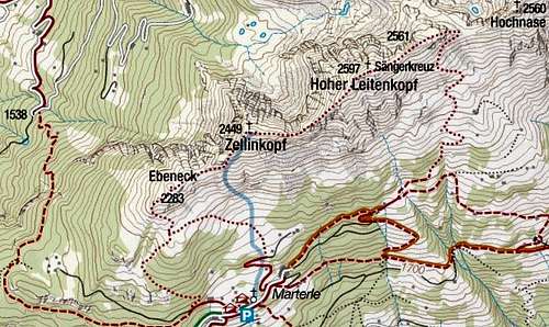 Source - Kompass online.


