
|
|
Mountain/Rock |
|---|---|
|
|
46.38860°N / 121.4047°W |
|
|
Lewis & Yakima |
|
|
Hiking |
|
|
Spring, Summer, Fall |
|
|
6660 ft / 2030 m |
|
|
Over(Lake)view
Yes, it has a view of a lake. It actually has a view of many lakes, some named, many unnamed or too small to be considered a lake (i.e. ponds). It also has views of many other things, including present-day volcanoes and bygone volcanoes, sitting atop magma lakes underground.Lakeview Mountain has these views because it possesses a triality of prominence (1380 ft), isolation (6.1 miles), and an open summit (i.e., not forested). Although, the west view is obscured a bit from the summit landing area, an easy stroll westward past the coppice of evergreens opens up this compass direction. The most outstanding views are of Mt. Adams (the present-day volcano) and the Goat Rocks (the bygone volcano).
The views from the summit make it worth the effort of getting there, which isn’t really that bad. Most the approach is trail and the off-trail part is short and not really technical. The Pacific Crest Trail travels close by so the summit may be visited quite a lot although the lack of entries in the summit register left by Fay Pullen in 2011 gives one pause on this conjecture.
Where is Lakeview? Lakeview is located 3 miles southeast of popular Walupt Lake and 13 miles northeast of Mt. Adams. The south half of the mountain lies within the Yakama Indian Reservation. The north half is within the Goat Rocks Wilderness. So this means there are no roads on the north side and the roads that are on the south side are only permitted for Yakama tribal members or those granted access by that tribe. Lakeview also lies on the Cascade Divide (hence the proximity of the PCT). The north side drains to the Cispus River which eventually empties into the Columbia River at Longview, WA. While the south side drains to the Klickitat, which also empties to the Columbia, but a half-dozen miles northwest of The Dalles, OR.
What is Lakeview? Lakeview Mountain is a shield volcano that was active in the Pleistocene Epoch. In other words: anywhere from 1.8 million years ago to about 12,000 years ago, with the likely timeframe of activity in the middle Pleistocene. When viewed from many vantage points, the mountain is apparent as a shield volcano. There is much evidence of basalt lava bombs on the mountain’s upper slopes.
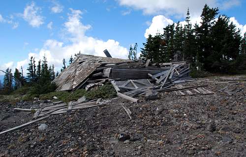
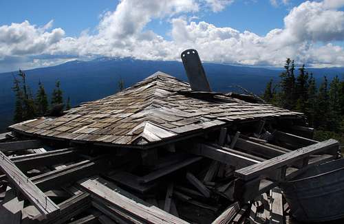
The mountain was also once the home of a lookout. The lookout actually lies about 60 yards south of the true summit. If you go by the border on the topo map, the lookout actually resides within the reservation. The lookout was in use from 1935 to 1945, at which time it was abandoned. I’m not sure why it would be abandoned so quickly. It commands a superior view of the flattish reservation lands northeast of Mt. Adams. The lookout is still there, though you would have to be pretty short like a rat or a snafflehound to get inside. The walls have fallen in. The roof is now lying on the floor. It is not considered a “remaining Washington lookout” but is worth a visit anyway.
Getting to the View There
There are three ways to get to Lakeview Mountain. These will be ordered counterclockwise starting from the north (from Walupt Lake). This isn’t a listing of easiest to hardest because the easiest would be if you were a Yakama member.I am assuming you can figure out how to get to the trailheads listed herein. This is the modern world, meaning you have access to maps on the internet.
From Walupt Lake
From Walupt Lake(3926 ft) it is about 6.5 miles to the summit with only about the last half-mile being off-trail. Take the Walupt Lake Trail past the north side of the lake, which is over a mile long. The trail rises slightly as it bends around the lower south toe of Nannie Peak and then descends about 100 ft to get to Walupt Creek, which it crosses. In early season Walupt Creek flows with enough vigor as to require a bridge to cross (a tandem of large logs do the job). In late season the creek is dry or flowing under the gravel bed. The creek does not drain any perennial snowfields. The trail then climbs up a series of switchbacks for 600 vertical feet then levels off for a stretch before reaching Short Trail Camp (which was unsigned but is pretty obvious to the left, northeast of the trail) in 4.2 miles. In another quarter-mile reach the PCT crossing at 4960 ft. Continue straight across the PCT on a trail that gets a bit more brush-encroached but is still pretty good.
Eventually the trail exits the forest at 5200 ft (5.2 miles from the trailhead). At this point there is a wye in the trail. The left path is an old 4WD track—the end of Howard Lake Road, which enters the wilderness for a short stretch (more on that later). The right path is the one you want to carry on to Lakeview.
The right path first goes past a sizable, but unnamed lake then trends southwest toward Pt. 5642, where it goes past a few more ponds before reaching picturesque Gertrude Lake (5736 ft) about 6.5 miles from the trailhead.
There is a trail that goes around the east side of the lake and one that goes to a horse camp on the north end of the lake. We took the latter route for our finish. There may be a way trail around the far east buttress of the summit and then up that side but we didn’t investigate it. The satellite image suggests a trail over there in places but it is not distinct enough to be certain.
From the horse camp on the north side of the lake the idea is to ascend the steepening woods right of the obvious talus slope. About halfway up the woods at about 6000 ft a talus bowl will be encountered (unless you veer too far right in the woods). The heathery fringe between the talus and the woods is the easiest way to go. At the apex of the talus bowl is a chute (break in a minor cliff band) that allows access to the upper part of the mountain.
After climbing up through the chute turn left and traverse across 30 feet of loose talus to a tree and heather bench. At this point you will likely encounter the old lookout phone line running along the ground. You may even trip over it once or twice like I did.
Turn right and walk up to the final north ridge. At this point you’ll go past what appears to be a very old crater. Maybe.
And then….and then…you might just get to kick steps up an ash dune. Not a sand dune. An ash dune. Mt. St. Helens ash deposited here in dump truck loads on the lee side of the ridge. If you’re slower than your partner like I was, you’ll appreciate the use of someone else’s steps kicked up the slope for you. The feeling and effort is similar to plodding up powdery snow.
And then…and then you are there, at the summit. The Fay Pullen register is in a cairn out in the open (i.e., not in the trees to the right where the slightly higher highpoint is located).
Time: 3 hours from car + time spent enjoying your surroundings (lakes, etc.), 6.5 miles, 2800 ft of gain.
From the West
The mountain can be approached cross country from the west from the PCT. The approach to the PCT from a car can be shortened (I have not verified on the ground that this road is drivable, but satellite imagery would appear to say it can be driven).
From FR-2164, which junctions off the road to Walupt Lake about 2.5 miles before the lake, find spur 034 at 3996J (“the junction at 3996 ft) and proceed up the hill to spur 405 at 4340 ft. Spur 405 makes a switchback at 4560 ft. At this point one could make short 200-yard walk NE through the woods to reach a trail that is trending NW-SE. Take the trail SE to meet the PCT at 5200 ft in Protracted Block PB 53 less than a mile up the hill. Alternatively, drive farther up the road, perhaps to 4760 ft, to lessen the elevation gain, but with a longer cross-country trek through the woods to meet the PCT. Going too far south on the spur 405 will probably produce diminishing returns.
Once on the PCT, follow it up and around Pk 5740+ (could tag that peak on the way by). The trail drops to 5060 ft at the broad lake-strewn saddle about two miles west of Lakeview Mountain. Continue on the PCT into PB 59 and leave it where it is most feasible (probably around 5100 ft) then head in a generally ESE direction toward the mountain. Stay to the right (south) of a large talus basin on the NW flank and ascend trees and heather to the summit.
Time: 2 hours from car + time spent doing other things (peakbagging, etc.), 5.5 miles, 2600 ft of gain on the way up, 600 ft of gain on the way back.
From Howard Lake
If for some reason you could get to (drive to) Howard Lake in the Yakama Indian Reservation, you can actually drive all the way to the wilderness boundary at the 5060 pass one mile NE of the summit. A high-clearance vehicle may be required.
At the pass there is an outhouse with a pretty nice looking white throne in it (I’d poop there). Just to the left of the outhouse a track leads to a picnic table, a fire pit with grate, and a trash can (the trash can was overflowing….who empties trash cans in a wilderness, anyway?), all of which are apparently just inside the wilderness boundary if the signs planted in the middle of the road truly straddle the boundary.
Continue past the picnic table down the track past a pond for about a third-mile to the wye described in the Walupt Lake description above. If in doubt, inspect a satellite image. This is all visible on the satellite. Proceed as per the Walupt Lake decription.
Time: 1 hour from car + time spent doing other things (lake bagging, etc.), 1.5 miles, 1600 ft of gain. Note though that the time spent driving around and to Howard Lake would not make it worth going that way anyway, unless you’re already a tribal member.
Camping There
There is camping at Walupt Lake Campground or in many roadside pull-outs on the way to the lake.There is camping at Short Trail Camp about 4 miles from the trailhead. This camp features a nice small lake to enjoy.
One could camp at the picnic table and fire pit at the pass northeast of the peak as described in the Howard Lake approach.
Suitable camping is also available at Gertrude Lake and probably at pretty Le Conte Lake south of the summit.
The summit has enough flat areas to that it would be camp-worthy. I seem to recall a bivy in the small trees right at the summit.
And of course Howard Lake on the reservation has camping.
The Red Tape There
This is the Goat Rocks Wilderness. You know what to do and not do in a wilderness.I don't recall seeing signs demanding a Trail Park Pass or a Washington DNR pass.
There is parking for maybe 15 cars at the trailhead. One side of the lot appears to be reserved for camp sites on that side. Not to worry, though, for there is additional parking on the other side of the bridge one crosses to get into the campground.
When to Climb There
You can climb it any time of year providing you can get close enough to make it worth your while. Walupt Lake and the approach is probably snowed in most years until late June.The technicalities of the climb should not be harder than Class 2. But you can find harder terrain if you desire it. The east face above Gertrude Lake is precipitous old basalt.
The Geology There
Geologic Map of Washington (Schuster, 2005)Note: This is a PDF scan. Warning: large MB file.
Geologic Map of Mt. Adams Area (Washington DNR, 1987)
NOTE: This is a Zip file with internal contents of PDF scans and Excel spreadsheet.
