
|
|
Route |
|---|---|
|
|
48.59469°N / 122.15906°W |
|
|
Overview
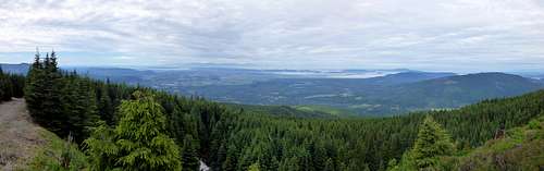
After putting it off for years, I recently decided to make a journey up Lyman Hill. Being equipped with a mountain bike, I decided the 25 mile round trip via the Scott Paper Road would be preferable to banging around in the brush on the west side. Things went well enough for me until I got about five miles in, just after starting up the 110 road. At this point, I suffered through about half a mile of nasty tank traps and dug up stream culverts. Shortly after the last of the tank traps, a prominent road joined from the left side, the road bed improved, and the rest of the ride to the top was uneventful. Views from the top were surprisingly good, although it was necessary to move around the summit area a bit to see in all directions.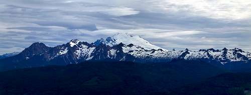
Take Highway 20 east from Sedro Wooley to Pipeline Road (8.2 miles east of the Hwy. 20/Hwy 9 North intersection). Turn left on Pipeline Road, and follow it north for 1.1 miles to a gate (N48 32.696 W122 03.256 Elev. 420'). Do not enter this area with your vehicle if the gate is open, as it may be closed at any time. There really are no good parking spots here, just look for any adequate place on the side of the road. Follow the road (now gravel) for approximately 1.5 miles, where you will arrive at a small quarry (N48 32.969 W122 04.088 Elev. 1030'). You will notice a road coming in from the right (This is Road 110 coming from Scott Paper Road, which is the classic Southeast Approach), and the main road now effectively becomes Road 110. Stay left on the main road, and continue following Roads 110 and 150 for another 8.0 miles to the summit.
While this route is shorter than the Southeast Approach (19 miles RT vs. 25 miles), it is still long enough that a mountain bike should be considered standard equipment. Those without wheels are probably better off making the approach from the west.