
-
 1349 Hits
-
 77.48% Score
-
 8 Votes
|
|
Route |
|---|---|
|
|
46.44332°N / 13.82049°E |
|
|
Download GPX » View Route on Map |
|
|
Hiking, Mountaineering, Scrambling |
|
|
Spring, Summer |
|
|
A long day |
|
|
T6/T5 Swiss Hiking Scale (up to UIAA II) |
|
|
Overview
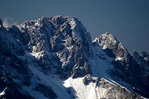
The smaller sister (2468 m) of Velika Ponca is a bit less attractive mountaineering goal than Velika Ponca, but it adds nicely to the beautiful outlook of Martuljek Group and also the views from its summit are nice. The two mountains are separated by a ca. 2415 m high notch, which can be reached from both sides, from the S-SW and from the N-NE. The northern route, described here, is a bit easier and more recommended.
The northern route on Mala Martuljška Ponca is a long, quite demanding hike-up, with a short summit part which requires some easy climbing. On this tour you learn the northern side of the massif very well, reaching at the end a lonesome summit. In times of tour skiing, this route is also a nice, but again demanding ski tour, on which short sections must be done on foot.
General Characteristics
|
Route Description

See the Bivouac III in Martuljek group page how to reach Za Akom basin!
From the lowest part of Za Akom basin we continue by a weak trail along the right (westernmost) ravine. Then tre trail gets lost in screes, but we cross the ravine, heading towards the high wall of Široka peč. Just right of it we see a hill with the last high larches. There we go - by the left ravine. The next stretch goes by the overgrown ridge, separating two ravines, just above the left one. Then the trail ends and we must descend left into the steep ravine between the wall of Široka peč and the hill with larches. The higher we go, the steeper the terrain. Finally we are able to cross towards the right, gaining the nice promontory of Three Larches (Ca. 1800 m).
From the Three Larches we continue ascending steep, open sandy slopes towards the south. That's quite unpleasant. Higher the first scree fields may appear. Don't go by them too high (some 150 m), because you need to detour the rocks of Oltar which you see on the right. So, turn west and try to lose no altitude, getting around there. Reaching broader scree/snow fields, you will see above you the long couloir of Kačji jezik (Snake's Tongue). That's the route for Oltar and Velika Ponca, but we must continue crossing the slopes towards the west, soon even towards the north-west. We must reach another gravel ridge, descending from below the rocks north of Velika Ponca.
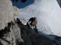
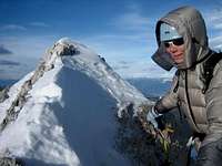
After this unpleasant section we reach a flat part south of the Na Pečeh ridge bump. To the left the view on the notch and the couloir leading to it opens. It's not too steep, only the upper part requires some care if snow is hard. On the notch we turn right, attacking the summit ridge. Climbing is mostly close to UIAA I degree, with details of UIAA II. The direction is mostly straight up, choosing the best passages. There's a considerable exposure.
Descent. We descend by the same route. The only exception may be, when we have good conditions for skiing. In that case, we can ski down even before reaching the promontory of Three Larches, as indicated on the map on this page. returning on foot, it's always best to go past the Three Larches.