
-
 6963 Hits
-
 73.06% Score
-
 3 Votes
|
|
Route |
|---|---|
|
|
39.60200°N / 106.1846°W |
|
|
Hiking |
|
|
Spring, Summer, Fall |
|
|
Most of a day |
|
|
Walk Up (Class 2) |
|
|
Overview
While this peak can be approached from many sides, this appears to be the shortest and most direct route to summit. It basically consists of a trail hike through a spectacular area to a gentle ridge climb with some light scrambling. The views of the more rugged peaks to the north provide knockout scenery.
Overall from the trailhead
Roundtrip distance: Appx 12 1/2 miles
Vertical Gain: Appx 3800'
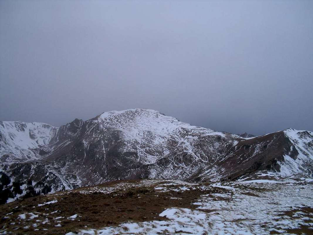
The route above Eccles Pass as seen from UN 12313 "Eccles Peak"
Getting There
Exit I-70 at Frisco (Exit 203) and continue around the roundabout on the north side of the expressway to a dirt frontage road that parallels the highway to the west. After about 1/2 mile you will come to a dirt parking area and the signed Meadow Creek trailhead at approximately 9150'.
Approach
Starting at the 9150' trailhead the approach is a class 1 trail hike for approximately 5 miles to 11,900' Eccles Pass. The trail starts sharply and heads into the forest following the Meadow Creek drainage. After approximately 1 mile you will reach a turn off for the Lily Pad Lake trail and shortly after enter the wilderness. The trail then continues steeply to a good log bridge stream crossing at appoximately 10,000'. Above this point the trail becomes steep and will test your stamina over the next 800' of rise. The trail then begins to level as it exits the forest and begins to enter the namesake meadows. You will cross a large flat meadow at approximately 11,300' with views to Eccles Pass and the surrounding peaks ahead. Join the northbound Gore Range Trail at 11,450' before climbing steeply the last half mile to Eccles Pass at 11,900'. This is a good place to take a break and admire the views of Red Peakand the Willow Massif.
Note: Alternate approach possible via Ryan Gulch and South Willow Creek, see the main page for a description.
Route Description
Beginning at Eccles Pass the route begins to your west. You will first have to drop down on the south side of the ridge crest to avoid some thick pine bushes. When practical, reclimb back to the ridge crest. Here the route's crux tower will draw your attention. This tower will require a few third class moves and the top of the tower provides some exciting exposure to the north. Beyond the tower is an exposed "easy class 3" catwalk like section before the slopes return to their more gentle nature. If this brief scrambling and exposure is not to your liking, you can bypass the tower to the south on talus side-hilling. Continue above the tower on the ridge crest to PT 12435, or bypass PT 12435 to the south on talus. From PT 12435 descend to the 12,260' low point on Deming Mountain's northeast ridge. This image shows the route from Eccles Pass to this 12,260' low point.
Above this point follow gentle grass and talus slopes for approximately 650' of vertical to the gentle summit of Deming Mountain. These slopes have beautful wildflowers in the summer. This image couresty of Jon Bradford captures the slopes and wildflowers perfectly.
Descend the way you came, possibly with a side trip to UN 12313 "Eccles Peak" (see below). You could also avoid the scrambling section by descending from the saddle with the false summit down a gully system back to the trail, these steep gullies have a mix of rock, dirt and grass and can be tedious, but avoid the exposed ridge crest if you do not wish to cross that section.
 |
 |
 |
Essential Gear
The route is little more than a trail hike and should not require any special gear under normal conditions.
This could be a difficult approach in winter as there is some potential avalanche terrain along the way.
Extra Credit
From Eccless Pass you can also climb neighboring UN 12313 "Eccles Peak". This is also a ranked 12er and rises approximately 413' from Eccles Pass. Follow a strong climbers trail for 3/4 mile along the west ridge to the summit and enjoy the surrounding views.
Route Map
Couresty of Jon Bradford, this route is the one indicated in blue.
