
|
|
Mountain/Rock |
|---|---|
|
|
39.04704°N / 119.53821°W |
|
|
Douglas |
|
|
Hiking, Scrambling |
|
|
Spring, Fall, Winter |
|
|
8319 ft / 2536 m |
|
|
Overview
Mineral Peak is a prominent summit in the Pine Nut Mountains southeast of Carson City, Nevada. Mineral Peak is separated from the main ridge that makes up the spine of Pine Nut Mountains. Mineral Peak can probably be considered the highest "foothill" of the mountain range, even though it is about as high as Rawe Peak, the northernmost summit in the range.Unlike some other prominent summits in the Pine Nut Mountain range, access to Mineral Peak is pretty straightforward. It is reached by a direct road accessible to 2WD automobiles, and offers a pleasant day-hike without thick brush or very difficult terrain.
Reaching the top of Mineral Peak isn’t necessarily easy, but for those in good physical fitness, the summit can be reached within a couple hours.
From the summit, there are excellent views towards neighboring peaks in the Pine Nut Mountains, particularly Mount Como 9005’. Views of the Sierra Nevada are spectacular, with a myriad of high peaks to pick out on a clear day.
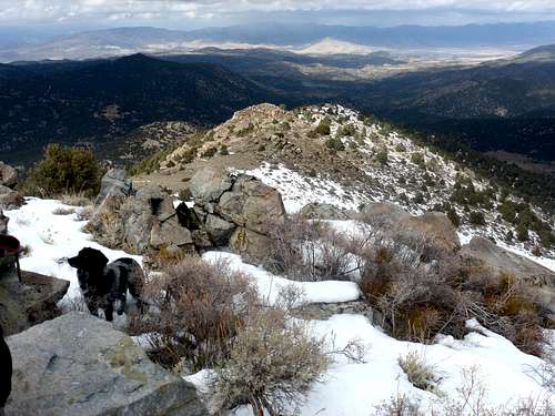
View north from the summit towards one of the rocky bumps
The best time to hike up Mineral Peak is probably later in fall (late October-early December), particularly during dry conditions. We hiked in February of 2012 with snow on the east face, and some mud on the roads. If dry weather is encountered during springtime this is perhaps an even better time to hike. Summers are typically too hot to climb this mountain. Wet conditions always makes access trickier.
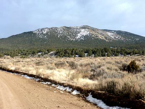
West face of Mineral Peak - 2/11/2012
Getting There
Getting to Mineral Peak is petty straightforward. If coming from Reno, Nevada drive south on 395 through Carson City. Continue south towards Minden. Before you get there, take Johnson Lane (State Route 209) off of 395. The turn off is 6 miles south of the 395 junction with US Highway 50 West in Carson City.Johnson Lane is a paved road that heads east for about 4 miles. It then turns into Sunrise Pass Road (a well-graded dirt road) and follows east all the way to Smith Valley. At one point, perhaps about half way up Sunrise Pass Road, there is a Y-junction that may be confusing as it is unmarked. Stay right. After this, it is pretty straightforward the rest of the drive. Just stay on the main road.
A low clearance 2WD is safe for the first 9 miles or so of the dirt road, until the road enters a canyon, and a high clearance 2WD or SUV is recommended. In a little over a mile, you will exit the canyon and the road enters a valley, where approach routes start. A good location to park is by a Y-junction just after exiting the canyon. There are a few places to park on the side of the road, including a campsite just 1/10th of a mile west of the Y-junction. Mineral Peak rises straight above to the east.
Route Information
There are multiple ways to approach Mineral Peak from Sunrise Pass Road. This page focuses on two: The West face and the East face.West face
The most straightforward way up to Mineral Peak is the west face. It looks daunting, as it is covered in pinyon pine trees and brush. However, piles of rocks leave open part of the west face for straightforward off-trail hiking. While steep, this route reaches the summit in 3 miles and 1800’ from the Y-junction area.
Play on Google Earth™ or topographic maps to check the roads. It is more obvious this way when planning this hike. Here are the general directions.
From the Y-junction continue to the right (south) for a mile, and the road curves towards the mountain. After another 1/3 mile the road curves to the left. After ¼ miles, you reach an intersection. The road heads to the right. After ½ mile, it switchbacks left underneath Mineral Peak.
At this point, at just below 7250’, walk a hundred yards or so, and then head straight up the slope. There are solid rock piles and light brush. The further up you go, the easier it is to follow. This is still the crux of the climb. In a little over 2/3rds of a mile you gain 1,000’ hitting a meadow just south of the rocky summit of Mineral Peak, which you will hit in about 3 miles from the parking area.
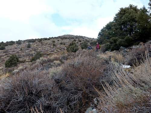
Looking back up the West face
You can descend the same way. Although, when you get back to the road you can head north to make it a loop. This adds ½ mile or so. Just follow the road below the west face until you reach another road heading west down to the valley.
East face
The east face is another option, not too much further in distance. It is less treacherous than the West face. Although it is steep, it isn’t as hard, except when on snow. It is mostly low brush that is easy terrain to walk through. This is a good option if hiking in early morning, due to better views based on the direction of the sun.
From the Y-Junction head south for ¼ mile and take a road heading towards a lower hill north of Mineral Peak. The road switchbacks up the hill for 1 ¼ miles. Then you will see a road descending to the side north of Mineral Peak. Take this road down towards the valley where it reaches a junction in about ¾ miles. Head to the right, and follow this road along the east side of Mineral Peak. It starts in the forest surrounded by pinyon pine trees. After 2/3rds of a mile you will see a road heading directly towards Mineral Peak.
From here the slope up to Mineral Peak is open and treeless. The summit is a mile as the crow flies. But it should take 1 ½ miles or so to get there, depending on which way you take. The recommendation is heading left off the road up to the east ridge. This is pretty straightforward and heads easily up to the summit. It is probably better to descend via the west face, via a route obvious from the summit.
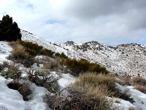
Heading up the east ridge. View towards rocky bump north of the summit.
The round trip hiking distance is about 7 ½ miles if hiking the East face and descending the West face.