-
 15627 Hits
-
 91.45% Score
-
 35 Votes
|
|
Mountain/Rock |
|---|---|
|
|
46.40080°N / 13.08020°E |
|
|
Hiking, Scrambling, Via Ferrata |
|
|
Spring, Summer, Fall |
|
|
6250 ft / 1905 m |
|
|
Overview
You probably know the old song: 'Vino Amaro, vino Amaro'. Yes, amaro wine has its origin right here, in Amaro, some 300 m above the see level, on the southern slopes of Monte Amariana. But we are not here because of wine, it's mountains, which are interesting for us. Whenever I was passing by with car, this nice, stand alone mountain was catching my eyes. Then I read it was famous by its flora in spring and by its broad panorama - and its position on my wish list was rising more and more.
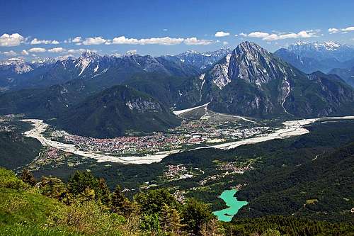
No doubt it is the home mountain of Tolmezzo city, the centre of Carnia. With a few rugged side summits its massif is rising more than 1600 meters above the confluence of Tagliamento and Fella rivers. And, luckilly, you can't drive up very high on the mountain. From Amaro a narrow mountain road goes up to some 980 m, but you must be lucky to reach its end with a car. In June 2006 we had to stop on some 700 m, because the road was hopelessly covered with tons of rock, which came down by a ravine in winter.
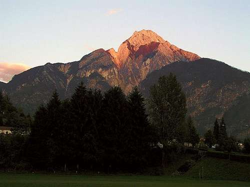
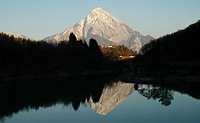
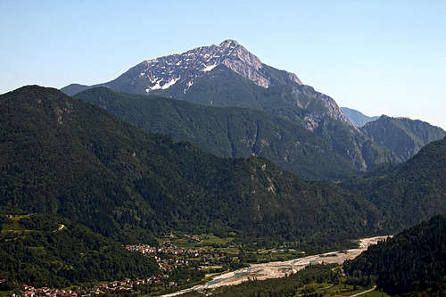
As you can see from pictures, Monte Amariana is a nice pyramid. Its slopes are steep, parts of the western ridge look even quite wild, and also the easiest approach from the South requires overcoming a rocky barrier and is secured with a cable. And, indeed, in June its southern slopes are full of blossoming flowers of all kinds. Primarilly it's a mountain for hikers, its routes are of all kinds of difficulty. Some are very long, especially the W-E traverses.
Geology
The beautiful appearance of Monte Amariana can be attributed to the fact that is built mostly of Triassic main dolomite (dolomia principale), 203 to 216 million years old. In the summit part of the mountain however the main dolomite is covered by a bit younger (199 to 203 million years old) Dachstein limestone. The third rock type is much less important - only on a few places of Amariana's south face grey Jurassic limestone can be found.
Dachstein limestone is mechanically hard, but water easily dissolves it, while the main dolomite is more brittle, but also more resistant to water. That's why we'll see that on the S side of Mariana there are some karst features, even underground caves, but also some rare water sources.
The second, very interesting geological feature is Amariana's tectonic. Originally the mountain was one big alpine fold. But due to some very active geological faults, the huge fold was in millions of years cut, so it eroded to the present wild shape. The most significant fault is the one, going along Torrente Citate. You can't miss Rivoli Bianci, the huge debris cone, one of the biggest debris fans in Europe, flowing out of the huge fracture.
Geography
The massif of Amariana is actually only one strong ridge, running in the W-E direction. Further to the west, there's the independent Strabut mountain, not belonging any more to Amariana. It's a home summit of Tolmezzo, culturally rich, with many nice trails ascending it.
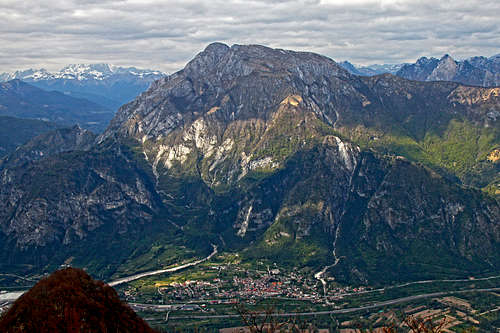
The massif of Amariana has three very different sides. The broad southern face is dotted with ex alpine pastures, meadows are reaching the summit ridge, but there are also high and steep rocky barriers, with abysses and characteristic slabs. Distinct ravines, most of them dry, are cutting the southern face. Due to relatively low altitudes a big portion of the lower areas is forested and in some places the trees are reaching also the main ridge.
The northern side of Amariana is completely different. First of all it's remote. Even if in the past there were some clearings wit pastures, today it's only hunters and forest workers who can be found there. It's almost completely forested, the highest parts of the N face are also rocky and very steep. So, a wild, abandoned, almost pathless wilderness, all the way down to Torrente Variola, flowing along the bottom.
The wildest, most rugged and attractively looking is the western side of Amariana. Spires, rock towers, wild notches and ridges are all what remains as the forces of tectonics are ruining the mountain. In addition to the deep fracture of Torrente Citate, there are also other steep, hardly passable ravines.
Even if we are speaking of the Amariana massif, there's almost only one summit to mention - the main one. Just east of it, beyond a small notch, the eastern foresummit, 1887 m, is rising only a little out of the main ridge. More important is the summit of Monte Amarianute, 1084 m. Despite its low altitude, its western position offers great views on the main summit. All other summits have so poor prominence that their importance lies only in playing some orientation role.
Online Map
Use the map below, also when on mountain tours. It's very detailed and its information is reliable. On this map there's a lot more information than on the rest of this page. Click on items and you'll get them one by one. Red are marked, official CAI trails. Non-marked trails are shown as much as they are embedded in the origina OpenStreetMap.
Illegio and Pieve di San Floriano
As mentioned in the Getting There chapter, the village of Illegio is one of the trailheads for Monte Amariana (from the NW). But the village and its neighbourhood is worth visiting itself. If you have additional two hours, this is worth seeing there:
Illegio
This nice village, inhabited already in the times of Ancient Romans, is situated on a picturesque small plane among the mountains. From Tolmezzo you have only some 10 minutes of drive till there, but the plane can not be seen from the surrounding main valleys. Rewarding is a stroll among picturesque old houses and especially visit of a series of old moulins, lined along a creek, having its source in the middle of the village. The sixteenth century Mulin dal Flec and the seventeenth century Mulin dal Ross (still in operation) are especially picturesque. In the last years in Illegio many artistic exhibitions are held.
Pieve di San Floriano
Some 40 min of walk from Illegio, on a steep, 734 m high, dominant hill above the valley of But, the church of San Floriano stands. This treasure of medieval beauty, was first built in the 9th century, and later renovated. It is a nice place itself, with stunning views on Carnia, but it has also a great historical importance.
Recent archaeological excavations have revealed by the church an early Christian site of San Paolo (4th century), a Longobard fortification, a small Carolingian church and remains of medieval Castellan houses. It looks that where today the church stands alone, once there was a fortified settlement.
The hike from Illegio to San Floriano is short and pleasant. A narrow road takes you out of the village and soon ends north of it. From there the ancient path descends to the creek, crosses it by a picturesque pedestrian bridge and ascends on the other side on the meadows, called Damiele. From there you continue up and in some 15 minutes again reach out of the woods. On a big, grassy mound the church of San Floriano stands and soon you can enjoy the views from its terrace and the flare of the place.
This short tour can be prolongated on Monte Gjaideit, 1082 m, which offers even broader views around.
Summit Panorama
As towards the South Carnic Alps are here already lowering down to the Po river plane, the panorama from Monte Amariana includes also the view on Adriatic sea. On the East Julian Alps are stretching, Monte Canin and Montaz being the most prominent peaks in the view. Towards the North and the West you can see virtually all Carnic summits - in the main ridge and on both sides of Tagliamento river - and beyond Carnic Alps of course also Dolomites and Hohe Tauern. Of course, only one visit in a cloudy day is not enough to show you pictures of all that.
Getting There
For the broader overview see the main Carnic Alps page and the Southern Carnic Alps GROUP page!
The mountain is rising just above the highway Udine - Tarvisio - Villach. You exit it for Tolmezzo, drive towards Tolmezzo and in Amaro deter right into the village. If you are arriving from the West, you are probably coming over Passo Mauria and driving down by the Tagliamento valley. You pass Tolmezzo, reaching Amaro.
Once in Amaro you need to find the mountain road, which ascends up the southern slopes of Monte Amariana. The easiest way is to keep as much towards the East as possible. Then you just drive straight up and later left, crossing the slopes. It then depends on the road conditions how high you can reach. Ideally, if the road is completely cleaned, you park on a small saddle in a side ridge, some 1058 m high.
The second option for an ascent is Illegio, on the NW side of Monte Amariana. It can be reached from Tolmezzo's Eastern part, driving towards the North.
Routes Overview
Marked trails
1. Normal South Route (No. 414). From Amaro, cca 290 m over the S slopes. 1600 m, 5 h. Walk-up, 100 m of the ravine below the summit ridge are steep, secured with a steel cable. Avoid hot summer days!
Description: You start walking as high as possible on the road, ascending from Amaro over the S slopes of Monte Amariana. There are fine parking places in the vicinity of a big ravine, higher there are hardly any, unless you reach the saddle on the side ridge, on 979 m. The trail No. 414 deters from the road just below the saddle, on the Amaro side. Fist some 300 m of the slope the trail does in many turns - through woods, over nice ledges, crossing steep slopes, all the time you can enjoy views down on Amaro. When reaching the distinct rocky wall, the path turns a bit right, avoids rocks through the last beeches and above them, reaches a broad and again quite steep grassy slope. Nevertheless, the trail is all the time comfortable, until it reaches the last rocky barrier. Good 100 m below the eastern summit ridge the path enters a distinct, but shallow ravine. It becomes steeper and goes directly upwards. Here a steel cable is installed for protection. At first it is not needed much, later it can help less experienced. Reaching the summit ridge a broad northern panorama opens. Now you turn left (westwards) and ascend by the summit ridge some 60 m more.
2. Sentiero Romano Cimenti (No. 443). From Illegio, 576 m, by the Ricovero Cimenti, 1070 m, and Sella Pradut, 1050 m. Northern approach. 4 h 15 min. Marked walk-up, a few steel-cable protections.
3. Sentiero alpinistico Mario della Marta. From the parking place on the road Amaro - Tolmezzo, at the ex gun-powder factory, cca 300 m. This route is harder than the previous two and some 6 h long. But its variety and very scenic points make it a great route. First it goes up on Monte Amarianute and the nearby Forcella della Citate, Then it continues towards the east on the summit. It's marked, but requires also some exposed, easy climbing.
4. East ridge route. This is a very long ascent, usually combined with staying in Ricovero Casera Monte Forcella. That bivouac can be ascended from the S by the marked trail No. 415, then that mark follows the main (E) ridge towards the west all the way to the summit. But in lower parts there are also many non-marked ex shepherds trails, gaining the main ridge.
Non-marked trails
|
On the online map above you can see many variants and route proposals. They are all bearing the heritage of shepherds, local hunters and other mountain lovers, who were in the past much more present on Amariana than they are today. You see that especially on the southern side, pastures were reaching almost till the main ridge. Big flocks of animals were the source of wealth of local people. As you see, all unmarked trails are east of the normal southern ascent route. Trails on Cjastelut and Posselie can be combined, in the upper part over Cuel Taront and Plan di Val the main ridge can be reached. Even more towards the east there are the Amariana meadows (Lower and Upper) and the meadow of Valaconin. I trust almost all trails depicted on the OpenStreetMap are faithfully mapped, even if some of them can be hard to follow, especially in summer, when they are overgrown. |
Stavoli. The Carnian word stavolo (agglomeration is stavoli) denoted a rural building (one-story or two-story) in the Alps, which was in the first place a shelter for domestic animals. Directly it could be translated as "stable". Stavoli are also used to store the hay obtained from the mowing of alpine meadows, tools and the upper story usually was used also to accomodate people. |
Red Tape
No limitations.
Mountain Huts And Camping
Interesting enough, Monte Amariana ascents are not supported with any mountain hut. We can only wish it stays so! But there are 3 bivouacs which enable visitors to cut the long ascent into 2 or 3 parts:
- Ricovero Cimenti Floreanini, 1070 m. North of the summit.
- Ricovero Plan d'Aiars, 1475 m. On the E ridge.
- Ricovero Casera Monte Forcella, 1098 m. On the E ridge.
L'Ors di Pani
On Stavolo Amariana di Sotto, 609 m, Antonio Zanella, named l'Ors di Pani lived - in solitude, despite the fact that he was very wealthy. Named Ors (=Bear) by his wild red hair and beard, he was a shy person, but often generous to unknown people, coming by. During the World War 2 he supported resistance and sacrificed a big flock of animals to fleeing Cossaks. Just one more story, showing his original personality: When travelling to Venice, he took accommodation in the best hotel, Danieli. Aristocratic clientele was looking with surprise the wild appearance of l'Ors, even more when Zanella reacted by covering the busy lunch table with an expanse of banknotes. In 1955 Antonio Zanella was killed together with his daughter, but the legend of l'Ors lives on.
When To Climb?
Monte Amariana can be climbed virtually any time of the year, but in hard winter the ascent can be very demanding and would require full winter equipment. The southern approach is very hot, so avoid summer days. So, the best time is autumn, September and October. But if you want to enjoy the full blossom of Monte Amariana's southern slopes, you need to come early in June. In 2006 we had a very cold spring, so on June 4th only the lower parts (up to some 1300 m) were covered with blossoming flowers.
Books, Outside Links
- Guidebook in Italian: R. Gaberscik: Guida escursionistica alle Alpi Carniche. STUDIO64srl Edizioni. 7th edition, 2010.
- Andrea Moro (editor): Da 200 a 2000 metri con il CAI di Tolmezzo. A very detailed description of almost all ascents and trips around Tolmezzo. With many historical explanations. In Italian.


