
-
 7779 Hits
-
 81.84% Score
-
 14 Votes
|
|
Mountain/Rock |
|---|---|
|
|
46.11204°N / 8.83052°E |
|
|
Hiking, Skiing |
|
|
Summer, Fall, Winter |
|
|
5689 ft / 1734 m |
|
|
Overview
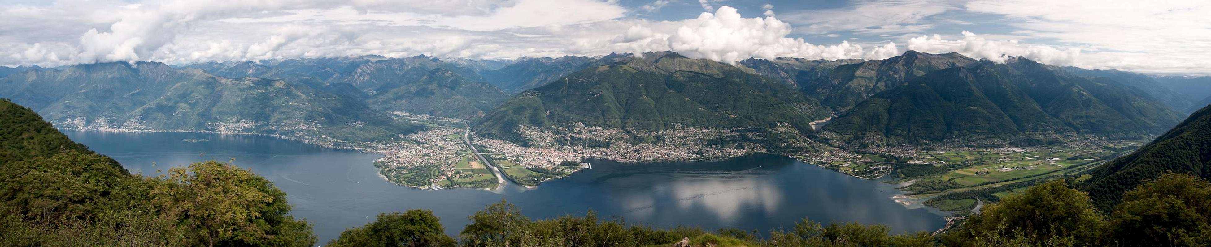
 Monte Gambarogno (far left) and Lago Maggiore seen from Monti di Lego Monte Gambarogno (far left) and Lago Maggiore seen from Monti di Lego |
In the very south of Switzerland's southernmost Canton Tessin / Ticino. between Lago Maggiore and Lago di Lugano, there is a small and low mountain range, famous for its wonderful views which range from the Valais Alps in the west to the Ortler / Cevedale Group in the west. The main ridge, which culminates in Monte Tamaro, is wonderfully panoramic, and the ridge traverse, locally called La Traversata is one of the most scenic hikes of the whole area.
A little to the west, separated from the main ridge by Valle Veddasca, is a second, lower ridge, which is by no means less scenic. While the views don't range as far as from La Traversata, here you have perfect views of Lago Maggiore 1500m below and the mountains in its vicinity. The highest mountain on this ridge, Monte Gambarogno, is its most popular one, mainly thanks to its very short ascent route, which starts at Alpe di Neggia, a road pass separating Valle di Vira from Valle Veddasca. From the saddle the ascent takes little more than half an hour but there are more rewarding routes, starting at the Monti (see below) at around 800m elevation.
 |  |  |
Monte Gambarogno is a broad backed mountain. Its summit stretches for about a kilometre in a 90° bend, starting in the north and ending in the west. The cross has been placed on the northernmost summit of this ridge while the real summit is located somewhat close to its western end. As the ridge, of which Monte Gambarogno is the northernmost part of, is cut in two by the Swiss - Italian border, you can find old army barracks in the vicinity of the summit (mich like on Tamaretto the western side summit of Monte Tamaro. Also, a dirt road leads to these barracks, which naturally facilitates the ascent by a large degree. However, ignoring the road, and following the path along the ridgeline is more rewarding and thanks to the fact that the road is invisible from up there you can perfectly ignore it.
 Monte Gambarrogno seen from Tamaretto
The best ascent routes to Monte Gambarogno either start on the shores of Lago Maggiore (huge elevation gain) or at an elevation of some 800m at Monti di Gerra, Monti di Vairano or Monti di Piazzonga. In former times these hamlets were inhabitad during intervals of the transhumance, the yearly move from the lowlands (shores in winter) to the Monti (spring, Autumn) and the Alpi (mountain pastures in summer). Today the Monti have been rediscovered and thanks to their wonderful location are used as weekend or holiday homes. From there steep paths lead across the north-western slopes of Monte Gambarogno, heading for the long summit ridge from all directions. Elevation gain is some 1000m and you'll find spots with wonderful views, especially from the last 300m around the top.
The Swiss villages on the shore of Lago Maggiore as well as their Monti and the mountain village Indemini merged into the political community of Gambarogno, the mountain in their midst. In 2007 the merger was put up for a vote, which resulted in an acceptance of 66 - 84%. In 2008 the fusion was accepted by the Ticino parliament and since April 2010 the new community Gambarogno is reality.
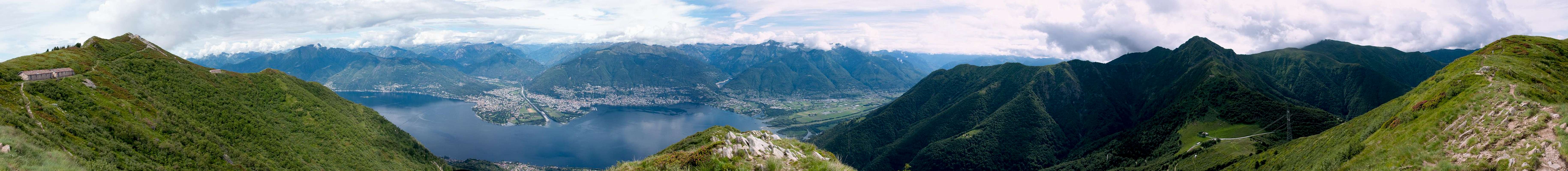
360° Summit Panorama
  |
Getting There
Trailheads for Monte Gambarogno are at Alpe di Neggia, Monti di Piazzogna, Monti di Vairano and Monti di Gerra. They all can be reached from the shores of Lago Maggiore by steep and sometimes very narrow mountain roads.- Take the Gotthard Motorway A2 to the exit Bellinzona Sud
- Switch to A13, direction Locarno.
- At Quartino turn off left (two roundabouts) in direction Magadino, Vira
- For Alpe di Neggia, Monti di Piazzogna and Monti di Vairano leave the lakeshore road at Vira (signs for Indemini). For the Monti turn off right in a switchback at some 800m.
- For Monti di Gerra stay on the lakeshore road until you reach Gerra. From here a narrow mountain road takes you to the Monti.
Red Tape
 Alpenroses on the Gambarogno summit
You are in the border region between Switzerland and Italy. Both ratified the Schengen treaty so there are no border controls. But be sure to bring an ID just in case.
Accommodation
 |
There is plenty of accommodation to be found on the web, mainly apartments or holiday homes. However, Tessin / Ticino has become very expensive so you will have to carefully plan your vacation. Most expensive are the cities (Lugano, Locarno, Ascona) but also the villages on the shores of the lakes can burn deep holes in your pockets. In general the higher up and the better the view the more expensive.
A good alternative is agritourismo - farm holidays, either in the valleys or in one of the spring / autumn settlements at an elevation of around 1000m.
You can find accomodation of any type using the following url:
http://www.ticino.ch
Weather Conditions
Maps & Books
Maps
- Digital Maps
- Regular Maps
- Malcantone
Carta Escursionistica 286 T
Ufficio Federale di Topografia Swizzeria
1:50.000
ISBN: 9783302302867
- Malcantone
Books
- Tessin
M. Hempel
Kompass Guidebook WF997
Kompass Verlag
ISBN: 3-85491-771-6
- Tessin
H. Bauregger
Rother Verlag
ISBN: 978-3-7633-4078-1
- Tessin
E.E. Hülsler
Bruckmann Verlag
ISBN: 978-3-7654-3653-6