-
 1430 Hits
-
 81.18% Score
-
 13 Votes
|
|
Route |
|---|---|
|
|
46.89796°N / 12.12130°E |
|
|
Mountaineering |
|
|
Spring, Summer |
|
|
Most of a day |
|
|
Alpine F+ |
|
|
Overview
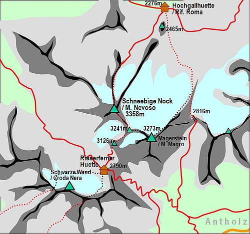
Monte Magro Normal route from Rifugio Roma
Like all the mountains in South Tyrol, also this high peak has two names: the Italian one, Monte Magro, and the original Tyrolean, Magerstein. Monte Magro 3273 m is located in the Rieserferner Group (Vedrette di Ries), between Forcella d'Anterselva and Pizzo delle Vedrette. With an altitude of 3273 m it's a very popular summer destination both from the Northern side (Rifugio Roma / Kasseler Hütte) and from the Southern one (Rifugio Vedrette di Ries / Rieserferner Hütte). Moreover Monte Magro is a coveted destination for ski-mountaineering ascents. It will be decribed on this page the Normal route from North starting from Rifugio Roma.

|

|
Getting There
The starting point to climb is the Jausestation Säge 1.591 m, just beyond Riva di Tures, where it starts the path to the Rifugio Roma / Kasseler Hütte.
Road access
Across Val Pusteria - from A22 Autobrennero exit Bressanone and take the road to Brunico (Val Pusteria). In Brunico leave the Val Pusteria road and take on the left the road to Valle Aurina. Once getting the village of Campo Tures leave the main road and turn right following the signpost to Riva di Tures. Here follow the signpost to the Jausestation Säge.

Walk to the refuge
From the Jausestation Säge the trail n. 8 climbs steeply into the woods, reaching Malga Eppacheralm 2041 m and soon joins the trail coming on the right from Riva di Tures (less steep but longer). At the crossroads we take on the left a less steep path which proceeds towards the shelter, reached in about 20 minutes after crossing a scenic suspended bridge.
Route Description
Monte Magro Normal route Refuge Roma
Difficulty: F+ (Alpine scale)
Difference in level: 997 m from Rifugio Roma
A fine and worthwhile itinerary, crossing a vast and interesting glacier, but never too complicated. The itinerary has various variations.
The Rifugio Roma is an important crossroads of paths, almost all are the approaches to climb up the summit of the different high peaks of the Vedrette di Ries group that surround the refuge.
")
|

|
Just behind the mountain hut you take the path in the middle that climbs directly up the steep slope behind the shelter and in just a few minutes reaches Lake Covoni / Tristensee.
 in very dry condition")
Near the lake bend slightly to the left following the path n. 4 to the Forcella di Anterselva, which goes around the slopes of a characteristic tower, Monte Covoni. Continue on the path n. 4 (to the Forcella di Anterselva), overcoming several bumps and valleys. It's always visible on the horizon to the left the binomial Collaspro/Collalto.

|

|
Indicatively at about 2600 m of altitude there is a unmarked fork: the main path continues in the same direction and leads to another fork, at about 2760 m, where the route takes the obvious NE ridge that will lead to the Monte Magro without passing on the glacier (possible variant). Instead the glacier route leaves the marked path following the cairns on the right. Without an obligatory way the route climbs up in the S-SW direction, following some pleasant granite slabs and uncertain tracks on the moraine (cairns) to the start of the wide glacier.

|

|
Here it will be decribed the glacier route: at the top of the wide morainic slope we find ourselves at the beginning of the vast glacier (Western Vedrette di Ries). After having roped up, we start to climb the glacier, which runs at first rather steep, then moderate. The track proceeds alongside the rocky NE ridge that borders the glacier on the left, reaching the Vedretta di Monte Magro in the upper part.

|

|
We are just below the top of the mountain, near a saddle along the NE ridge. Climbing without obligatory path along the boulders of the NE ridge you reach the summit with the characteristic signal.

|

|
Another possibility (a little longer) is to get around the mountain to the right on the glacier to reach the saddle between Monte Magro and Pizzo delle Vedrette and from here climb up the easy ridge to the left leading to the summit.
Descent: reversing the route
Essential Gear
Rope, axe, crampons, slings, glacier gear
Red Tape

No fees no permits required. Monte Magro is situated inside a protected natural area established in 1988, the Parco Naturale Vedrette di Ries-Aurina, bordering directly with the Parco Nazionale Alti Tauri and comprising an area of 31,320 hectares. The Vedrette di Ries-Aurina Nature Park includes the largest number of glaciers in the South Tyrolean nature parks and includes the following municipalities: Campo Tures, Valle Aurina, Predoi, Gais, Perca and Rasun-Anterselva, To the east it is bounded by the Passo Stalle and the state border with Austria, while the border to the south-east is the Valle di Anterselva and to the south the Val Pusteria. Characteristic in the Vedrette di Ries-Aurina Nature Park is its richness of water. There are also different varieties of animals such as the golden eagle, the marmot of the Alps, the alpine chamois, the roe deer and the red deer. The flora is also widely represented, with the Arnica montana, the Cinquefoglia fior d'oro, The Rifugio Roma is sometime also called Kasslerhütte or with the old name of Hochgallhüttethe Anemone and the Sassifragacee.
Hut

The Rifugio Roma is sometime also called Kasslerhütte or with the old name of Hochgallhütte.
Situation: at the altitude of 2274 m and due to its open position on a vast balcony it enjoys a breathtaking view over the Vedrette di Ries mountains and the Aurine Alps
Guardian: fam. Seeber
Hut phone: +390474 672 550
Mobile: +39 333 7238426
The refuge is an important starting point for hikes, mountaineering itineraries or ski mountaineering, all in the middle of the enchanting Vedrette di Ries Natural Park. The paths starting from the shelter lead almost all to important peaks that exceed 3000 meters, such as Monte Nevoso, Monte Magro, Sasso Lungo, Collaspro and Collalto; there are also crossings, like the Arthur Hartdegen path or the crossing to the Refuge Vedrette di Ries through the Forcella d'Anterselva.

|

|
When to climb
Mountaineering: summer is the good season to climb
Ski-mountaineering: from March to May
Meteo
METEO PROVINCIA BOLZANO ALTO ADIGE
Guidebooks
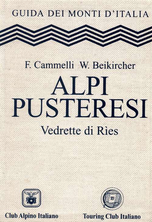
"Alpi Pusteresi - Vedrette di Ries" - F. Cammelli, W. Beikircher - Collana Guide dei Monti d'Italia CAI/TCI
Map